File:Ph map cavite.png
跳至導覽
跳至搜尋
預覽大小:569 × 600 像素。 其他解析度:228 × 240 像素 | 612 × 645 像素。
原始檔案 (612 × 645 像素,檔案大小:76 KB,MIME 類型:image/png)
說明
說明
添加單行說明來描述出檔案所代表的內容
摘要
[編輯]
| 描述 |
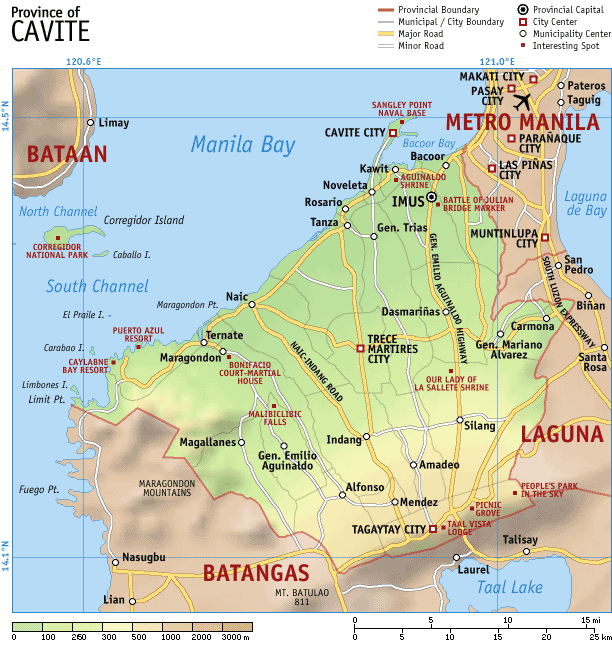
Map of the province of en:Cavite, en:Philippines. It is a topographic map showing the municipalities and cities, major and minor roads, and notable places of interest. Created and copyright (2003) by seav. Released under the GNU FDL. |
| 日期 | 2003年十月11日 (原始上傳日期) |
| 來源 | Transferred from en.wikipedia to Commons. |
| 作者 | 原上傳者為英文維基百科的Seav |
授權條款
[編輯]

|
已授權您依據自由軟體基金會發行的無固定段落、封面文字和封底文字GNU自由文件授權條款1.2版或任意後續版本,對本檔進行複製、傳播和/或修改。該協議的副本列在GNU自由文件授權條款中。 |
| 此檔案採用共享創意 姓名標示-相同方式分享 3.0 未在地化版本授權條款。 | ||
| ||
| 已新增授權條款標題至此檔案,作為GFDL授權更新的一部份。 |
原始上傳日誌
[編輯]
The original description page was here. All following user names refer to en.wikipedia.
檔案歷史
點選日期/時間以檢視該時間的檔案版本。
| 日期/時間 | 縮圖 | 尺寸 | 用戶 | 備註 | |
|---|---|---|---|---|---|
| 目前 | 2007年5月3日 (四) 14:19 | | 612 × 645(76 KB) | Ppntori(對話 | 貢獻) | {{Information |Description=Map of the province of en:Cavite, en:Philippines. It is a topographic map showing the municipalities and cities, major and minor roads, and notable places of interest. Created and copyright (2003) by [[:en:User:Seav|s |
無法覆蓋此檔案。
檔案用途
全域檔案使用狀況
以下其他 wiki 使用了這個檔案:
- cbk-zam.wikipedia.org 的使用狀況
- de.wikipedia.org 的使用狀況
- en.wikipedia.org 的使用狀況
- hy.wikipedia.org 的使用狀況
- id.wikipedia.org 的使用狀況
- jv.wikipedia.org 的使用狀況
- ka.wikipedia.org 的使用狀況
- mk.wikipedia.org 的使用狀況
- ru.wikipedia.org 的使用狀況
- tl.wikipedia.org 的使用狀況
- vi.wikipedia.org 的使用狀況
- war.wikipedia.org 的使用狀況
- zh.wikipedia.org 的使用狀況