File:PhiladelCampaignHessianMap.jpg

Originaldatei (1.510 × 1.282 Pixel, Dateigröße: 274 KB, MIME-Typ: image/jpeg)
Bildtexte
Kurzbeschreibungen
Beschreibung[Bearbeiten]
| Beschreibung |
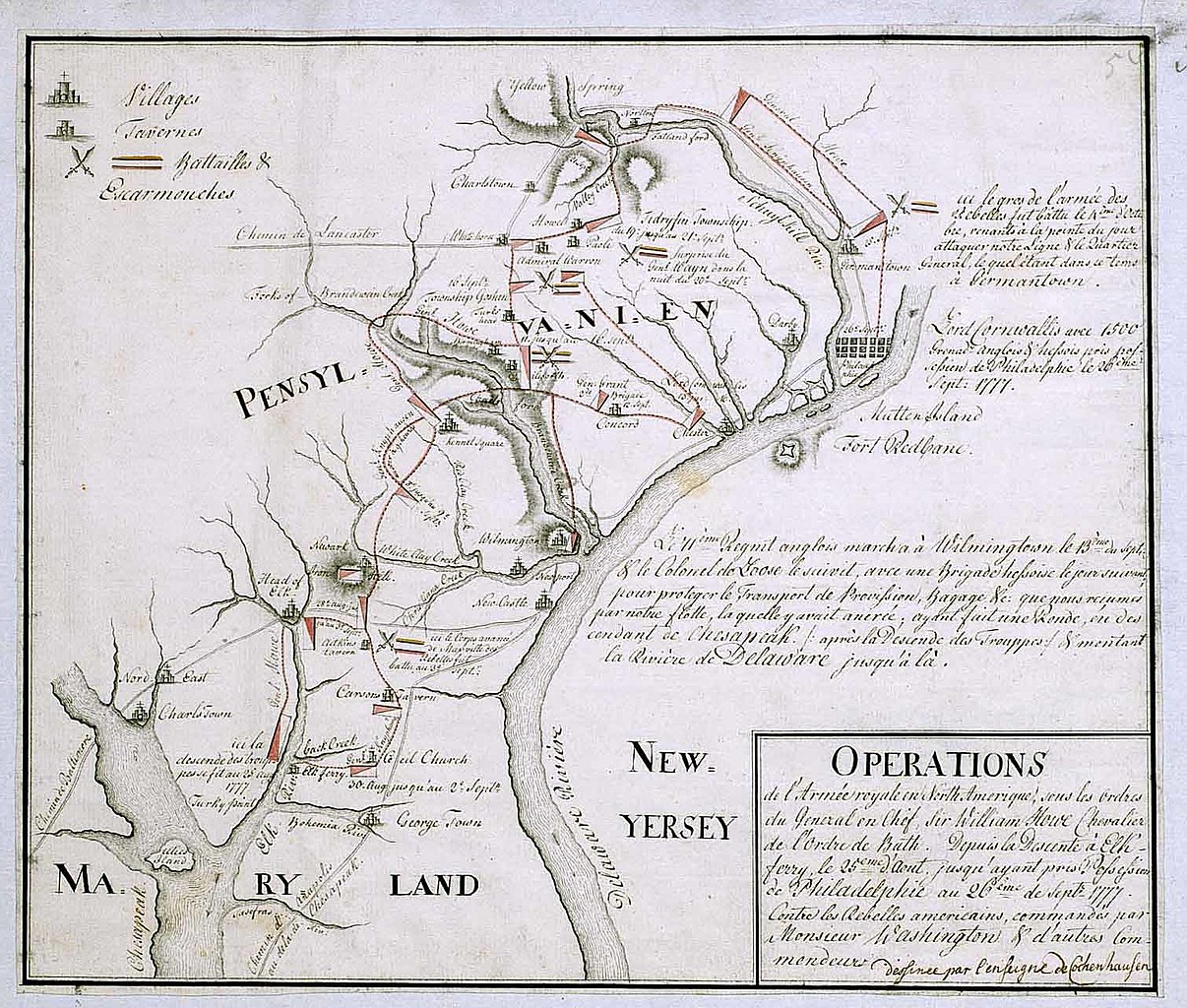
English: 18th century Hessian map from the Marburg State Library in Germany
of the Philadelphia Campaign (Battle of Brandywine, Forts Mercer and Redbank, Germantown, etc.) via the website of the West Jersey History Project http://westjerseyhistory.org/maps/revwarmaps/hessianmaps/index6.shtml Text in French, accompanying maps dated either 1777 or 1787 Quick translation"Operations of the royal army in North America under the orders of Sir William Howe, Knight of the Order of Bath. From the descent at Elk Ferry 25 August until taking possession of Philadelphia 26 September, 1777 against the american Rebels commandeed by Mr. Washington and other commanders. (Map) Designed by Ensign Cochenhausen" |
| Quelle | |
| Urheber |
Lizenz[Bearbeiten]
|
Dies ist eine originalgetreue fotografische Reproduktion eines zweidimensionalen Kunstwerks. Das Kunstwerk an sich ist aus dem folgenden Grund gemeinfrei:
Nach offizieller Ansicht der Wikimedia Foundation sind originalgetreue Reproduktionen zweidimensionaler gemeinfreier Werke gemeinfrei. Diese fotografische Reproduktion wird daher auch als gemeinfrei in den Vereinigten Staaten angesehen. Die Verwendung dieser Werke kann in anderen Rechtssystemen verboten oder nur eingeschränkt erlaubt sein. Zu Details siehe Reuse of PD-Art photographs. {{PD-Art}} template without license parameter: please specify why the underlying work is public domain in both the source country and the United States
(Usage: {{PD-Art|1=|deathyear=''year of author's death''|country=''source country''}}, where parameter 1= can be PD-old-auto, PD-old-auto-expired, PD-old-auto-1996, PD-old-100 or similar. See Commons:Multi-license copyright tags for more information.) | ||||
Ursprüngliches Datei-Logbuch[Bearbeiten]
- 2008-01-12 16:39 Smallbones 1510×1282×??? (280724 bytes) 18th century Hessian map from the Marburg State Library in Germany of the Philadelphia Campaign (Battle of Brandywine, Forts Mercer and Redbank, Germantown, etc.) via the website of the West Jersey History Project http://westjerseyhistory.org/maps/revwarm
Dateiversionen
Klicke auf einen Zeitpunkt, um diese Version zu laden.
| Version vom | Vorschaubild | Maße | Benutzer | Kommentar | |
|---|---|---|---|---|---|
| aktuell | 21:23, 20. Aug. 2008 | | 1.510 × 1.282 (274 KB) | File Upload Bot (Magnus Manske) (Diskussion | Beiträge) | {{BotMoveToCommons|en.wikipedia}} {{Information |Description={{en|18th century Hessian map from the Marburg State Library in Germany of the Philadelphia Campaign (Battle of Brandywine, Forts Mercer and Redbank, Germantown, etc.) via the website of the We |
Du kannst diese Datei nicht überschreiben.
Dateiverwendung
Keine Seiten verwenden diese Datei.
Globale Dateiverwendung
Die nachfolgenden anderen Wikis verwenden diese Datei:
- Verwendung auf azb.wikipedia.org
- Verwendung auf ca.wikipedia.org
- Verwendung auf cs.wikipedia.org
- Verwendung auf da.wikipedia.org
- Verwendung auf en.wikipedia.org
- Verwendung auf es.wikipedia.org
- Verwendung auf fa.wikipedia.org
- Verwendung auf fi.wikipedia.org
- Verwendung auf fr.wikipedia.org
- Verwendung auf gl.wikipedia.org
- Verwendung auf it.wikipedia.org
- Verwendung auf ja.wikipedia.org
- Verwendung auf ko.wikipedia.org
- Verwendung auf pl.wikipedia.org
- Verwendung auf pt.wikipedia.org
- Verwendung auf ro.wikipedia.org
- Verwendung auf ru.wikipedia.org
- Verwendung auf zh.wikipedia.org
Metadaten
- Battle of Brandywine
- Maps of the Philadelphia Campaign
- Pennsylvania in the American Revolution
- 1777 maps of Pennsylvania
- 1777 maps of Delaware
- 1777 maps of Maryland
- American Revolution in 1777
- French-language maps of North America
- British Occupation of Philadelphia
- German military personnel of the American Revolutionary War