File:Pincerno - Niederelbe 1860.jpg

Originaldatei (1.191 × 842 Pixel, Dateigröße: 315 KB, MIME-Typ: image/jpeg)
Bildtexte
Kurzbeschreibungen
Beschreibung
[Bearbeiten]
| Beschreibung |
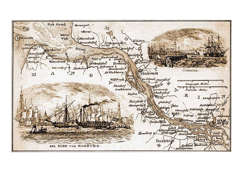
Deutsch: Niederelbe 1857 oder früher. |
| Datum | vor 1857 |
| Quelle | http://www.hamburg.de/bilder/hamburg-historisch/241658/historische-hamburg-ansichten-von-hafen-und-elbe.html#pic14 Von Pincerno am 9. Februar 2009 in die deutschsprachige Wikipedia geladen. |
| Urheber | Gebrüder Suhr († 1842 bzw. 1857) |
Lizenz
[Bearbeiten]
|
Dieses Werk ist gemeinfrei, weil seine urheberrechtliche Schutzfrist abgelaufen ist.
| |
| Es wurde festgestellt, dass diese Datei frei von bekannten Beschränkungen durch das Urheberrecht ist, alle verbundenen und verwandten Rechte eingeschlossen. | |
Dateiversionen
Klicke auf einen Zeitpunkt, um diese Version zu laden.
| Version vom | Vorschaubild | Maße | Benutzer | Kommentar | |
|---|---|---|---|---|---|
| aktuell | 17:50, 30. Mär. 2010 | | 1.191 × 842 (315 KB) | Mogelzahn (Diskussion | Beiträge) | {{Information |Description={{de|1=Niederelbe 1857 oder früher.}} |Source=http://www.hamburg.de/bilder/hamburg-historisch/241658/historische-hamburg-ansichten-von-hafen-und-elbe.html#pic14 Von Pincerno am 9. Februar 200 |
Du kannst diese Datei nicht überschreiben.
Dateiverwendung
Keine Seiten verwenden diese Datei.
Globale Dateiverwendung
Die nachfolgenden anderen Wikis verwenden diese Datei:
- Verwendung auf da.wikipedia.org
- Verwendung auf de.wikipedia.org
- Verwendung auf en.wikipedia.org
- Verwendung auf fr.wikipedia.org
Metadaten
- Maps of the Elbe
- Alster (River)
- Historic views of Hamburg by Suhr brothers
- 19th-century maps of Schleswig-Holstein
- 19th-century maps of Lower Saxony
- 19th-century maps of Hamburg
- Maps of Hamburg-Alsterdorf
- Maps of Hamburg-Altona-Altstadt
- Maps of Hamburg-Barmbek-Süd
- Maps of Hamburg-Blankenese
- Maps of Hamburg-Eidelstedt
- Maps of Hamburg-Eimsbüttel
- Maps of Hamburg-Eppendorf
- Maps of Hamburg-Finkenwerder
- Maps of Hamburg-Francop
- Maps of Hamburg-Fuhlsbüttel
- Maps of Hamburg-Harburg
- Maps of Hamburg-Langenhorn
- Maps of Hamburg-Moorburg
- Maps of Hamburg-Neuenfelde
- Maps of Hamburg-Neugraben-Fischbek
- Maps of Hamburg-Ottensen
- Maps of Hamburg-Wilhelmsburg
- Hamburg-Hausbruch
- Hamburg-Lurup
- Maps of Buxtehude
- Maps of Stade
- Maps of Wedel
- Brokdorf
- Brunsbüttel
- Old maps of Cuxhaven
- Freiburg/Elbe
- Maps of Glückstadt
- Jork
- Krempe
- Neuendeich
- History of Wilster
- Old maps of Ritzebüttel
- Old maps of Neuwerk