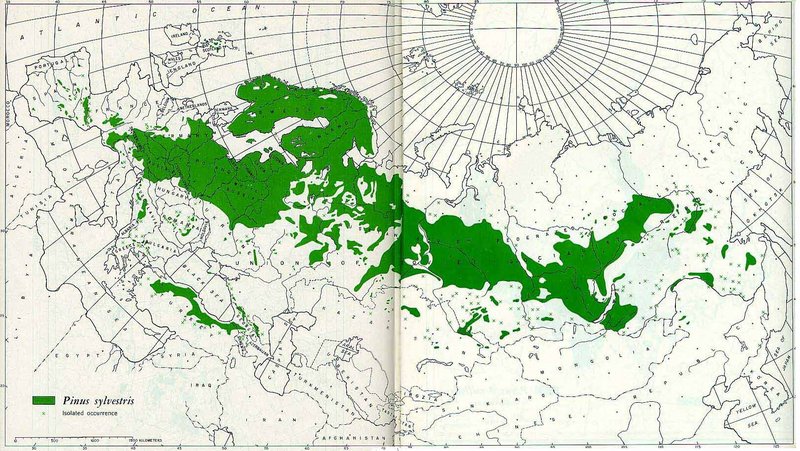
File:Pinus sylvestris distribution map.jpg
来自Wikimedia Commons
跳转到导航
跳转到搜索
Pinus_sylvestris_distribution_map.jpg (800 × 451像素,文件大小:143 KB,MIME类型:image/jpeg)
文件信息
结构化数据
说明
说明
添加一行文字以描述该文件所表现的内容
 | 这个file中的所有图片名上传在JPEG格式,即使它包含非照片数据。该信息可以以PNG或SVG格式更有效或更准确地存储。如果可能,请上传此图像的PNG或SVG版本,没有压缩失真,源自非JPEG源(或去除现存的失真)。完成后,请使用{{Superseded|NewImage.ext}}标记JPEG版本并删除此标记。此标签不应应用于照片或扫描件。如需更多信息,请参阅{{BadJPEG}}。 |
Pinus sylvestris (Scots Pine) range map (scanned from Geographic distribution of the pines of the world, USDA Forest Service Misc. Publ. 991, 1966)
| Public domainPublic domainfalsefalse |
This image is a work of the Forest Service of the United States Department of Agriculture. As a work of the U.S. federal government, the image is in the public domain.
|
 |
文件历史
点击某个日期/时间查看对应时刻的文件。
| 日期/时间 | 缩略图 | 大小 | 用户 | 备注 | |
|---|---|---|---|---|---|
| 当前 | 2005年8月15日 (一) 19:23 |  | 800 × 451(143 KB) | B.navez(留言 | 贡献) | Scots Pine range map (scanned from ''Geographic distribution of the pines of the world'', USDA Forest Service Misc. Publ. 991, 1966) {{PD-USGov-USDA-FS}} |
您不可以覆盖此文件。
文件用途
以下3个页面使用本文件:
元数据
此文件含有额外信息,这些信息可能是创建或数字化该文件时使用的数码相机或扫描仪所添加的。如果文件已从其原始状态修改,某些详细信息可能无法完全反映修改后的文件。
| JPEG文件备注 | File written by Adobe Photoshop¨ 4.0 |
|---|

