File:Plan Odendaal.png
跳至導覽
跳至搜尋
無更高解析度可提供。
Plan_Odendaal.png (418 × 418 像素,檔案大小:33 KB,MIME 類型:image/png)
說明
說明
添加單行說明來描述出檔案所代表的內容

|
本圖片是以PNG、GIF或JPEG格式上傳。然而,其中包含的資料或訊息,應該重新建立成可縮放向量圖形(SVG)檔案,以更有效率或更準確的方式儲存。如有可能,請上傳本圖片的SVG格式版本。在上傳之後,請修改維基各姊妹計畫中所有使用舊版圖片的條目(列在圖像連結章節中),替換為新版圖片,並在舊圖片的描述頁中加入{{Vector version available|新圖片名稱.svg}}模板,同時移除本模板。
|
摘要
[編輯]| 描述 |
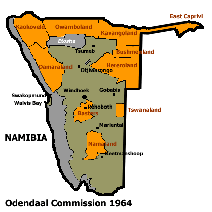
Español: Bantustanes en el territorio de Namibia con Damaraland al noroeste del país
English: This map shows the Odendaal Commission Plan for Namibia of 1964. The plan divided Namibia into Bantustans or Homelands. |
||||||||
| 日期 | |||||||||
| 來源 | |||||||||
| 作者 | Bries | ||||||||
| 授權許可 (重用此檔案) |
|
||||||||
| 其他版本 | French version : Image:Plan_Odendaal-fr.png |

檔案歷史
點選日期/時間以檢視該時間的檔案版本。
| 日期/時間 | 縮圖 | 尺寸 | 使用者 | 備註 | |
|---|---|---|---|---|---|
| 目前 | 2023年11月25日 (六) 22:00 | | 418 × 418(33 KB) | LoomCreek(留言 | 貢獻) | Transparency |
| 2005年4月21日 (四) 07:40 |  | 418 × 418(15 KB) | Bries(留言 | 貢獻) | This map shows the Odendaal Commission Plan for Namibia of 1964. The plan divided Namibia into ''Bantustans'' or ''Homelands''. I have created the map for the Wikipedia community. Category:Maps of Namibia {{GFDL}} |
無法覆蓋此檔案。
檔案用途
下列頁面有用到此檔案:
全域檔案使用狀況
以下其他 wiki 使用了這個檔案:
- af.wikipedia.org 的使用狀況
- ar.wikipedia.org 的使用狀況
- ast.wikipedia.org 的使用狀況
- bn.wikipedia.org 的使用狀況
- ca.wikipedia.org 的使用狀況
- Bantustan
- Hereros
- Resolució 301 del Consell de Seguretat de les Nacions Unides
- Resolució 309 del Consell de Seguretat de les Nacions Unides
- Resolució 310 del Consell de Seguretat de les Nacions Unides
- Resolució 319 del Consell de Seguretat de les Nacions Unides
- Resolució 323 del Consell de Seguretat de les Nacions Unides
- Resolució 342 del Consell de Seguretat de les Nacions Unides
- Resolució 366 del Consell de Seguretat de les Nacions Unides
- ckb.wikipedia.org 的使用狀況
- de.wikipedia.org 的使用狀況
- en.wikipedia.org 的使用狀況
- South West Africa
- History of Namibia
- Bantustan
- Kaokoland
- Bushmanland (South West Africa)
- Hereroland
- Ovamboland
- Damaraland
- Tswanaland
- Kavangoland
- Rehoboth (homeland)
- Namaland
- East Caprivi
- Fox Odendaal
- Diocese of Namibia
- United Nations Security Council Resolution 301
- Land reform in Namibia
- Aminuis
- Constance Kgosiemang
- es.wikipedia.org 的使用狀況
檢視此檔案的更多全域使用狀況。