File:Poland & The New Baltic States.jpg
Salta a la navegació
Salta a la cerca
Mida d'aquesta previsualització: 462 × 599 píxels. Altres resolucions: 185 × 240 píxels | 370 × 480 píxels | 592 × 768 píxels | 790 × 1.024 píxels | 1.376 × 1.784 píxels.
Fitxer original (1.376 × 1.784 píxels, mida del fitxer: 1,22 Mo, tipus MIME: image/jpeg)
Llegendes
Llegendes
Afegeix una explicació d'una línia del que representa aquest fitxer
| Descripció |
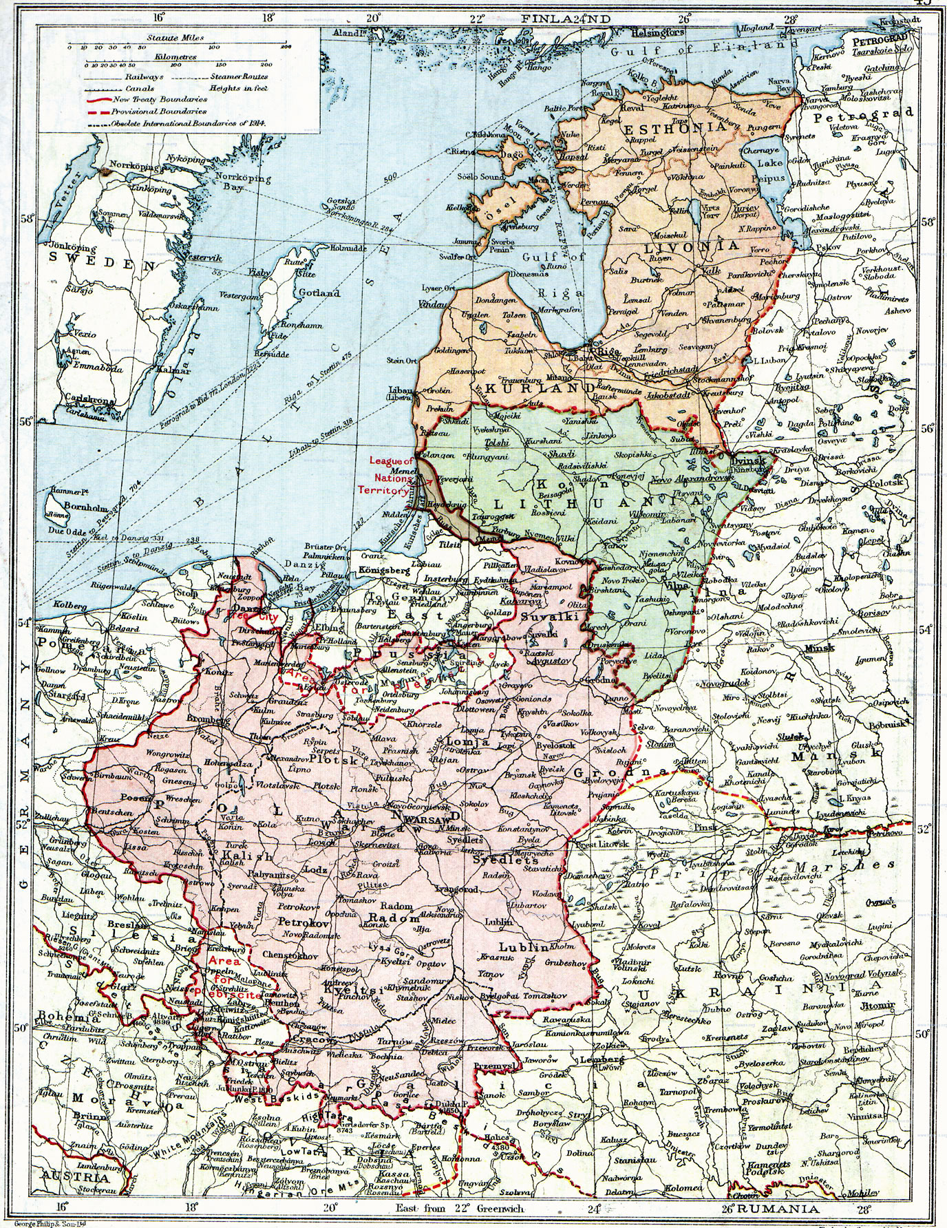
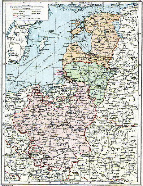
English: Map of Poland, en:Lithuania, en:Courland, en:Livonia and en:Esthonia published in the 1920 edition of The Peoples Atlas by London Geographical Institute.
The map shows the situation after the treaties of Versailles and Brest-Litovsk and before the en:Peace of Riga and the organization and recognition of the nation-states of en:Estonia and en:Latvia. Note that most names featured on this map are pre-1914 Russian names put in English transcription, rather than local or English names as such. |
| Data | |
| Font |
This uploaded map is a photoshopped version of the original image located at Image:London-geographical-institute the-peoples-atlas 1920 poland-and-the-new-baltic-states.jpg or [1]. Originally uploaded to EN Wikipedia as en:Image:Poland & The New Baltic States.jpg by en:User:MaGioZal 26 December 2007 |
| Autor | London Geographical Institute |
| Permís (Com reutilitzar aquest fitxer) |
According to the site, there are no copyrights to this map. |
| Altres versions | Image:London-geographical-institute the-peoples-atlas 1920 poland-and-the-new-baltic-states.jpg |
Aquest fitxer és en el domini públic en els Estats Units. Això és aplicable a obres dels EUA on el copyright ha expirat, sovint perquè la seva primera publicació va ser abans de l'1 de gener de 1929. Vegeu aquesta pàgina per a més detalls.
|
 | |
 |
Podria ser que aquesta imatge no estigui en el domini públic fora dels Estats Units (especialment on no s'aplica la regla del termini més curt per obres dels EUA, com Canada, la Xina continental (no a Hong Kong ni Macau), Alemanya, Mèxic i Suïssa). El creador i any de publicació són informació essencial i s'han de proporcionar. Vegeu Viquipèdia:Drets d'autor per a més detalls.
|
Historial del fitxer
Cliqueu una data/hora per veure el fitxer tal com era aleshores.
| Data/hora | Miniatura | Dimensions | Usuari/a | Comentari | |
|---|---|---|---|---|---|
| actual | 14:06, 26 juny 2010 | | 1.376 × 1.784 (1,22 Mo) | Ras67 (discussió | contribucions) | losslessly cropped with Jpegcrop |
| 07:47, 3 ago 2008 |  | 1.506 × 1.996 (1,28 Mo) | Rcbutcher (discussió | contribucions) | {{Information |Description=Map of Poland, Lithuania, Courland, Livonia and Esthonia published in the 1920 edition of ''The Peoples Atlas'' by London Geographical Institute. The map shows the situation after the treaties of [[Treaty of |
No podeu sobreescriure aquest fitxer.
Ús del fitxer
Les 3 pàgines següents utilitzen aquest fitxer:
Ús global del fitxer
Utilització d'aquest fitxer en altres wikis:
- Utilització a ar.wikipedia.org
- Utilització a bat-smg.wikipedia.org
- Utilització a ba.wikipedia.org
- Utilització a ca.wikipedia.org
- Utilització a da.wikipedia.org
- Utilització a de.wikipedia.org
- Utilització a en.wikipedia.org
- Utilització a et.wikipedia.org
- Utilització a fi.wikipedia.org
- Utilització a fr.wikipedia.org
- Utilització a gl.wikipedia.org
- Utilització a it.wikipedia.org
- Utilització a ja.wikipedia.org
- Utilització a lt.wikipedia.org
- Utilització a lt.wikibooks.org
- Utilització a lv.wikipedia.org
- Utilització a no.wikipedia.org
- Utilització a ro.wikipedia.org
- Utilització a ru.wikipedia.org
- Utilització a sl.wikipedia.org
- Utilització a sr.wikipedia.org
- Utilització a sv.wikipedia.org
Vegeu més usos globals d'aquest fitxer.