File:Polar Bear Habitat.png

Původní soubor (981 × 879 pixelů, velikost souboru: 605 KB, MIME typ: image/png)
Popisky
Popisky
Popis
[editovat]
| Popis |
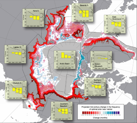
Projected changes (based on 10 IPCC AR-4 GCM models run with the SRES- A1B forcing scenario) in the spatial distribution and integrated annual area of optimal polar bear habitat. Base map shows the cumulative number of months per decade where optimal polar bear habitat was either lost (red) or gained (blue) from 2001–2010 to 2041–2050. Offshore gray shading denotes areas where optimal habitat was absent in both periods. Insets show the average annual ( 12 months) cumulative area of optimal habitat (right y-axis, line plot) for four 10-year periods in the 21st century (x-axis midpoints), and their associated percent change in area (left y axis, histograms) relative to the first decade (2001–2010). |
| Zdroj | Predicting The Future Distribution of Polar Bear Habitat in the Polar Basin from Resource Selection Functions Applied to 21st Century General Circulation Model Projections of Sea Ice |
| Autor | USGS |
Licence
[editovat]
Toto dílo je ve Spojených státech volným dílem, protože jde o dílo úřadů americké federální vlády podle ustanovení Hlavy 17, Kapitoly 1, Sekce 105 amerického právního řádu. Viz Autorské právo.
Upozornění: uvedené se vztahuje pouze na díla úřadů federální vlády, nikoliv na úřady jednotlivých států, okresů, či nižších územně správních jednotek.
|
 | |
| Bylo zjištěno, že u tohoto souboru nejsou známa žádná omezení daná autorským právem a právy s ním souvisejícími. | ||
Historie souboru
Kliknutím na datum a čas se zobrazí tehdejší verze souboru.
| Datum a čas | Náhled | Rozměry | Uživatel | Komentář | |
|---|---|---|---|---|---|
| současná | 24. 11. 2010, 16:54 | | 981 × 879 (605 KB) | PawełS (diskuse | příspěvky) | Bigger resolution. Screenshot of PDF in bigger zoom. |
| 30. 11. 2007, 22:46 |  | 610 × 546 (423 KB) | Sagredo (diskuse | příspěvky) | {{Information |Description=Projected changes (based on 10 IPCC AR-4 GCM models run with the SRES- A1B forcing scenario) in the spatial distribution and integrated annual area of optimal polar bear habitat. Base map shows the cumulative number of months |
Tento soubor nemůžete přepsat.
Využití souboru
Na tento soubor neodkazuje na Commons žádná stránka.
Globální využití souboru
Tento soubor využívají následující wiki:
- Využití na ar.wikipedia.org
- Využití na ca.wikipedia.org
- Využití na cs.wikipedia.org
- Využití na de.wikipedia.org
- Využití na en.wikipedia.org
- Využití na eo.wikipedia.org
- Využití na es.wikipedia.org
- Využití na fr.wikipedia.org
- Využití na gl.wikipedia.org
- Využití na gu.wikipedia.org
- Využití na hi.wikipedia.org
- Využití na kn.wikipedia.org
- Využití na pt.wikipedia.org
- Využití na si.wikipedia.org
- Využití na vi.wikipedia.org
- Využití na zh.wikipedia.org