File:Port of Cape Town.jpg
跳至導覽
跳至搜尋

預覽大小:800 × 461 像素。 其他解析度:320 × 184 像素 | 640 × 369 像素 | 1,024 × 590 像素 | 1,280 × 738 像素 | 2,560 × 1,476 像素 | 4,287 × 2,471 像素。
原始檔案 (4,287 × 2,471 像素,檔案大小:8.22 MB,MIME 類型:image/jpeg)
說明
說明
添加單行說明來描述出檔案所代表的內容
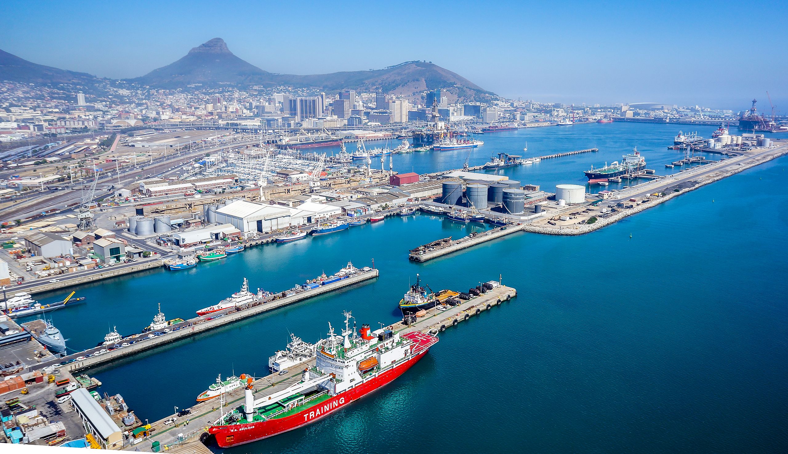
Looking west over the port of Cape Town
摘要
[編輯]
| 描述 |
Afrikaans: Die hawe van Kaapstad bly 24 uur per dag en 7 dae per week oop. Die diepte van die toegangskanaal is -15.9m onder reduksievlak, -15.4m by die 180m breë ingang na Duncandok en -14m by die ingang na Ben Schoemandok. Die diepte in Duncandok wissel tussen -9.9m naby die herstelkaai tot -12.4m by die tenkerbekken. Ben Schoemandok wissel van -9m tot -13,9m. Die huidige (d.i. 2010) baggerwerk in Ben Schoemandok (houerterminaal) berei dieper meerplekke vir nuwe generasie-houerverskeping.
English: The port of Cape Town remains open 24 hours a day 7 days a week. The entrance channel's depth below chart datum is -15.9m, -15.4m at the 180m wide entrance into Duncan Dock and -14m at the entrance to Ben Schoeman Dock. The depth in the Duncan Dock varies between -9.9m near the repair quay to -12.4m at the tanker basin. Ben Schoeman Dock varies from -9m to -13.9m. Dredging is currently (i.e. 2010) underway in the Ben Schoeman Dock (container terminal) to provide deeper berths for new generation container shipping. |
| 日期 | |
| 來源 | 自己的作品 |
| 作者 | SkyPixels |
| 拍攝地點 | | 位於此地的本圖片與其他圖片: OpenStreetMap |
|---|
授權條款
[編輯]
我,本作品的著作權持有者,決定用以下授權條款發佈本作品:
此檔案採用共享創意 姓名標示-相同方式分享 4.0 國際授權條款。
- 您可以自由:
- 分享 – 複製、發佈和傳播本作品
- 重新修改 – 創作演繹作品
- 惟需遵照下列條件:
- 姓名標示 – 您必須指名出正確的製作者,和提供授權條款的連結,以及表示是否有對內容上做出變更。您可以用任何合理的方式來行動,但不得以任何方式表明授權條款是對您許可或是由您所使用。
- 相同方式分享 – 如果您利用本素材進行再混合、轉換或創作,您必須基於如同原先的相同或兼容的條款,來分布您的貢獻成品。
檔案歷史
點選日期/時間以檢視該時間的檔案版本。
| 日期/時間 | 縮圖 | 尺寸 | 用戶 | 備註 | |
|---|---|---|---|---|---|
| 目前 | 2015年5月24日 (日) 17:40 | | 4,287 × 2,471(8.22 MB) | SkyPixels(對話 | 貢獻) | User created page with UploadWizard |
無法覆蓋此檔案。
檔案用途
下列2個頁面有用到此檔案:
全域檔案使用狀況
以下其他 wiki 使用了這個檔案:
- af.wikipedia.org 的使用狀況
- ang.wikipedia.org 的使用狀況
- bn.wikipedia.org 的使用狀況
- cs.wikipedia.org 的使用狀況
- cy.wikipedia.org 的使用狀況
- en.wikipedia.org 的使用狀況
- fi.wikipedia.org 的使用狀況
- he.wikipedia.org 的使用狀況
- hy.wikipedia.org 的使用狀況
- hyw.wikipedia.org 的使用狀況
- ko.wikipedia.org 的使用狀況
- ms.wikipedia.org 的使用狀況
- ne.wikipedia.org 的使用狀況
- nso.wikipedia.org 的使用狀況
- pl.wikipedia.org 的使用狀況
- ro.wikipedia.org 的使用狀況
- ru.wikipedia.org 的使用狀況
- sat.wikipedia.org 的使用狀況
- smn.wikipedia.org 的使用狀況
- sv.wikipedia.org 的使用狀況
- th.wikipedia.org 的使用狀況
- tr.wikipedia.org 的使用狀況
- zh.wikipedia.org 的使用狀況