File:Port of Rotterdam Landsat 8 Photo 8 May 2016.jpg
Aller à la navigation
Aller à la recherche

Taille de cet aperçu : 800 × 252 pixels. Autres résolutions : 320 × 101 pixels | 640 × 201 pixels | 1 024 × 322 pixels | 1 280 × 403 pixels | 5 016 × 1 578 pixels.
Fichier d’origine (5 016 × 1 578 pixels, taille du fichier : 6,73 Mio, type MIME : image/jpeg)
Légendes
Légendes
Ajoutez en une ligne la description de ce que représente ce fichier
Description
[modifier]
| Description |
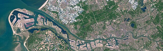
English: Satellite photo of the Port of Rotterdam in South Holland, the Netherlands. This image was captured on May 8, 2016 by the Operational Land Imager (OLI) on the Landsat 8 satellite.
Nederlands: Satellietfoto van de haven van Rotterdam in Zuid-Holland, Nederland. Deze foto is op 8 mei 2016 gemaakt door de Operational Land Imager (OLI) op de Landsat 8 satelliet. |
| Date | |
| Source | NASA Earth Observatory - https://earthobservatory.nasa.gov/images/91317/holland-first-stop-for-the-pilgrims |
| Auteur | NASA Earth Observatory images by Joshua Stevens, using Landsat data from the U.S. Geological Survey. Story by Adam Voiland. |
Conditions d’utilisation
[modifier]
| Ce fichier provient de la NASA. Sauf exception, les documents créés par la NASA ne sont pas soumis à copyright. Pour plus d'informations, voir la politique de copyright de la NASA. | ||
 |
Attention :
|
Historique du fichier
Cliquer sur une date et heure pour voir le fichier tel qu'il était à ce moment-là.
| Date et heure | Vignette | Dimensions | Utilisateur | Commentaire | |
|---|---|---|---|---|---|
| actuel | 24 juin 2023 à 19:47 | 5 016 × 1 578 (6,73 Mio) | Artanisen (d | contributions) | Uploaded a work by NASA Earth Observatory images by Joshua Stevens, using Landsat data from the U.S. Geological Survey. Story by Adam Voiland. from NASA Earth Observatory - https://earthobservatory.nasa.gov/images/91317/holland-first-stop-for-the-pilgrims with UploadWizard |
Vous ne pouvez pas remplacer ce fichier.
Utilisations locales du fichier
Les 9 pages suivantes utilisent ce fichier :
- Europoort
- Port of Rotterdam
- Rotterdam
- File:Rotterdam by Sentinel-2, 2018-06-30.jpg
- File:Satellite image of Europoort, Netherlands (4.25E 51.90N).png
- Category:Aker Wayfarer (ship, 2010) in Rotterdam
- Category:Harbour entrance lights in Port of Rotterdam
- Category:Port of Rotterdam
- Category:Shipping containers in Port of Rotterdam
.png)
Utilisations du fichier sur d’autres wikis
Les autres wikis suivants utilisent ce fichier :
- Utilisation sur ar.wikipedia.org
- Utilisation sur ast.wikipedia.org
- Utilisation sur ba.wikipedia.org
- Utilisation sur bn.wikipedia.org
- Utilisation sur ca.wikipedia.org
- Utilisation sur cs.wikipedia.org
- Utilisation sur de.wikipedia.org
- Utilisation sur el.wikipedia.org
- Utilisation sur en.wikipedia.org
- Utilisation sur eo.wikipedia.org
- Utilisation sur es.wikipedia.org
- Utilisation sur eu.wikipedia.org
- Utilisation sur fi.wikipedia.org
- Utilisation sur fr.wikipedia.org
- Utilisation sur he.wikipedia.org
- Utilisation sur hu.wikipedia.org
- Utilisation sur id.wikipedia.org
- Utilisation sur is.wikipedia.org
- Utilisation sur it.wikipedia.org
- Utilisation sur ko.wikipedia.org
- Utilisation sur li.wikipedia.org
- Utilisation sur ms.wikipedia.org
- Utilisation sur nds.wikipedia.org
- Utilisation sur nl.wikipedia.org
- Utilisation sur oc.wikipedia.org
- Utilisation sur pl.wikipedia.org
- Utilisation sur pt.wikipedia.org
Voir davantage sur l’utilisation globale de ce fichier.