File:PresidentialCounty1804.gif
跳至導覽
跳至搜尋

預覽大小:763 × 600 像素。 其他解析度:306 × 240 像素 | 611 × 480 像素 | 978 × 768 像素 | 1,280 × 1,006 像素 | 2,560 × 2,011 像素 | 2,800 × 2,200 像素。
原始檔案 (2,800 × 2,200 像素,檔案大小:126 KB,MIME 類型:image/gif)
說明
說明
添加單行說明來描述出檔案所代表的內容
摘要
[編輯]| 描述 |
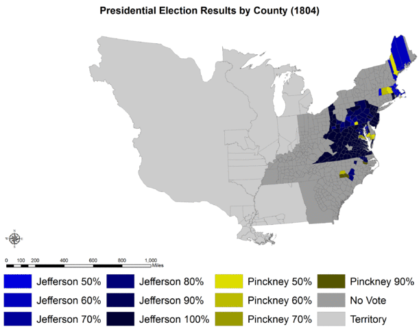
English: Presidential election results by county (1804). |
|||||
| 日期 | ||||||
| 來源 |
自己的作品. Original shapefile downloaded from: Minnesota Population Center. National Historical Geographic Information System: Version 2.0. Minneapolis, MN: University of Minnesota 2011. http://www.nhgis.org |
|||||
| 作者 | Tilden76 | |||||
| 授權許可 (重用此檔案) |
"Citation and Use of NHGIS Data All persons are granted a limited license to use this documentation and the accompanying data, subject to the following condition: Publications and research reports based on the database must cite it appropriately. The citation should include the following: Minnesota Population Center. National Historical Geographic Information System: Version 2.0. Minneapolis, MN: University of Minnesota 2011. If possible, citations should also include the URL for the NHGIS site: http://www.nhgis.org"
|
|||||
| 其他版本 |
|


授權條款
[編輯]
我,本作品的著作權持有者,決定用以下授權條款發佈本作品:
此檔案採用創用CC 姓名標示-相同方式分享 3.0 未在地化版本授權條款。
- 您可以自由:
- 分享 – 複製、發佈和傳播本作品
- 重新修改 – 創作演繹作品
- 惟需遵照下列條件:
- 姓名標示 – 您必須指名出正確的製作者,和提供授權條款的連結,以及表示是否有對內容上做出變更。您可以用任何合理的方式來行動,但不得以任何方式表明授權條款是對您許可或是由您所使用。
- 相同方式分享 – 如果您利用本素材進行再混合、轉換或創作,您必須基於如同原先的相同或兼容的條款,來分布您的貢獻成品。
檔案歷史
點選日期/時間以檢視該時間的檔案版本。
| 日期/時間 | 縮圖 | 尺寸 | 使用者 | 備註 | |
|---|---|---|---|---|---|
| 目前 | 2012年1月12日 (四) 17:43 | | 2,800 × 2,200(126 KB) | Tilden76(留言 | 貢獻) |
無法覆蓋此檔案。
檔案用途
全域檔案使用狀況
以下其他 wiki 使用了這個檔案:
- en.wikipedia.org 的使用狀況
- es.wikipedia.org 的使用狀況
- hu.wikipedia.org 的使用狀況
- ja.wikipedia.org 的使用狀況
- mk.wikipedia.org 的使用狀況
- uk.wikipedia.org 的使用狀況
- www.wikidata.org 的使用狀況
- zh.wikipedia.org 的使用狀況