File:Pressure chart geostrophic flow 2.jpg
跳转到导航
跳转到搜索
没有更高的分辨率。
Pressure_chart_geostrophic_flow_2.jpg (600 × 397像素,文件大小:171 KB,MIME类型:image/jpeg)
说明
说明
添加一行文字以描述该文件所表现的内容
摘要
[编辑]
| 描述 |
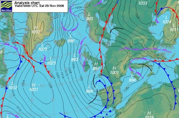
This is a daily pressure chart of North Atlantic Ocean and Europe based on measured values (analysis). Source: http://www.metoffice.gov.uk/weather/europe/europe_forecast.html Geostrophic-flow conditions are set when the isobars are approximately parallel and equally spaced. The air masses move along the isobars like a stream flow. An air stream flows from Arctic to mid latitudes south of the 40th parallel. Higher-pressure systems are found along the right-hand side of the stream, and lower-pressure ones on its left-hand side (northern-hemisphere arrangement) |
| 来源 | http://www.metoffice.gov.uk/weather/europe/europe_forecast.html |
| 作者 |
许可协议
[编辑]
_(St_Edwards_Crown).svg)
|
此文件已根据开放政府许可证1.0版 (OGL v1.0)。
|
|---|---|
| 署名:The Met Office | |
|
您可以自由:
有关更多信息,请参阅元维基上的开放政府许可证页面。
|
原始上传日志
[编辑]
The original description page was here. All following user names refer to en.wikipedia.
| 日期/时间 | 大小 | 用户 | 备注 |
|---|---|---|---|
| 2009-10-04 10:50:52 | 600 × 397 | Xavierstuvw | == Summary == Daily pressure chart (analysis) Sourcehttp://www.metoffice.gov.uk/weather/europe/europe_forecast.html (c) British Crown Copyright 2009, the Met Office == Licensing == {{attribution||British Crown Copyright 2009, the Met Office}} |
文件历史
点击某个日期/时间查看对应时刻的文件。
| 日期/时间 | 缩略图 | 大小 | 用户 | 备注 | |
|---|---|---|---|---|---|
| 当前 | 2017年2月25日 (六) 10:05 | | 600 × 397(171 KB) | FastilyClone(留言 | 贡献) | Transferred from en.wikipedia (MTC!) |
您不可以覆盖此文件。
文件用途
没有页面使用本文件。
全域文件用途
以下其他wiki使用此文件:
- en.wikipedia.org上的用途
- zh.wikipedia.org上的用途