File:ProspectPark 1901Plan.jpg

Fichier d’origine (4 017 × 2 536 pixels, taille du fichier : 2,66 Mio, type MIME : image/jpeg)
Légendes
Légendes
Description
[modifier]
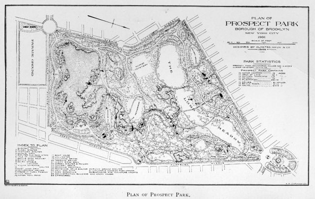
| Description | Plan of Prospect Park, Borough of Brooklyn, New York City |
| Date | |
| Source | 1902 Annual Report, New York City Department of Parks |
| Auteur | City of New York |
| Autorisation (Réutilisation de ce fichier) |
Published before 1923, Public Domain in the United States |
| Autres versions | Library of Congress: American Landscape and Architectural Design, 1850-1920, a lantern slide from the collection using the NYC Parks Department map as a source |
Remarks
[modifier]
This 1901 Plan map of Prospect Park, Brooklyn, NY was originally published in the 1902 Annual Report of the Department of Parks, City of New York. Map prepared by A. S. DeForest, Cartographer, for the George H. Walker & Company, Boston. There appear to be two errors in the map legend:
- 13, demarking 'East Wood Arch' (Meadowport Arch on the current (2006) map) appears to be located at the Thatched Hut (burned down 1937); the Thatched Hut is not indicated in the legend. The correct location of East wood (Meadowport) Arch is unmarked, but lies about 300 feet southwest of the misplaced marker; note where path appears to intersect/go under the West Drive.
- 28, demarking 'Administrative Buildings' appear to be where the greenhouses were located (demolished 1955).
Digital scan of the map furnished by Joy Holland, Research Librarian, Brooklyn Collection Brooklyn Public Library
Conditions d’utilisation
[modifier]
|
Cette œuvre est également dans le domaine public dans tous les pays pour lesquels le droit d’auteur a une durée de vie de 70 ans ou moins après la mort de l’auteur. | |
| Ce fichier a été identifié comme étant exempt de restrictions connues liées au droit d’auteur, y compris tous les droits connexes et voisins. | |
Historique du fichier
Cliquer sur une date et heure pour voir le fichier tel qu'il était à ce moment-là.
| Date et heure | Vignette | Dimensions | Utilisateur | Commentaire | |
|---|---|---|---|---|---|
| actuel | 8 septembre 2007 à 18:48 | | 4 017 × 2 536 (2,66 Mio) | Garry R. Osgood (d | contributions) | This replacement file is an image scan at 300 dot/inch of the map as published in the 1902 Annual Report of the City of New York Department of Parks. Scan furnished by Joy Holland, Research Librarian, Brooklyn Collection w:Brooklyn Public Library |
| 10 janvier 2007 à 18:40 |  | 2 048 × 1 370 (737 kio) | Garry R. Osgood (d | contributions) | {{Information |Description= Plan of Prospect Park, Borough of Brooklyn, New York City |Source= 1902 Annual Report, New York City Department of Parks |Date= 1901 |Author= City of New York |Permission= Published before 1923, Public Domain in the United Sta |
Vous ne pouvez pas remplacer ce fichier.
Utilisations locales du fichier
Aucune page n’utilise ce fichier.
Utilisations du fichier sur d’autres wikis
Les autres wikis suivants utilisent ce fichier :
- Utilisation sur de.wikipedia.org
- Utilisation sur en.wikipedia.org
- Utilisation sur fr.wikipedia.org
- Utilisation sur he.wikipedia.org