File:Prussian-Polish border in the 18th century.png
跳转到导航
跳转到搜索

本预览的尺寸:800 × 571像素。 其他分辨率:320 × 228像素 | 640 × 457像素 | 1,024 × 731像素 | 1,280 × 914像素 | 1,755 × 1,253像素。
原始文件 (1,755 × 1,253像素,文件大小:6.29 MB,MIME类型:image/png)
说明
说明
添加一行文字以描述该文件所表现的内容
摘要
[编辑]
| 作者 |
|
| 描述 |
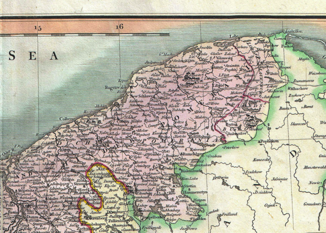
English: An attractive example of John Cary’s 1801 map of Upper Saxony, Germany. Covers from the Baltic Sea south to Franconia, Bavaria, Bohemia and Moravia. Extends eastward as far as Poland. Includes the Duchy of Silesia, the Duchy of Lusatia, Prussian Pomerania, Electoral Mark of Brandenburg, and the Margraviate of Meissen. Notes the cities of Berlin, Prague, Dresden, and Leipzig among many others. Highly detailed with color coding according to region. Shows forests, cities, palaces, forts, roads and rivers. All in all, one of the most interesting and attractive atlas maps of Upper Saxony to appear in first years of the 19th century. Prepared in 1801 by John Cary for issue in his magnificent 1808 New Universal Atlas . |
| 日期 | 2012年8月9日, 09:29 (UTC) |
| 尺寸 | 高度:18.5英寸(46.9厘米);宽度:20.5英寸(52厘米) |
| 登录号 |
Geographicus link: UpperSaxony-cary-1799 |
| 来源/摄影师 |
本檔案衍生自: 1801 Cary Map of Upper Saxony, Germany ( Berlin, Dresden ) - Geographicus - UpperSaxony-cary-1799.jpg: |
_-_Geographicus_-_UpperSaxony-cary-1799.jpg)
| 这是一张修改过的图片,这意味着它已在原版本的基础上通过软件进行了编辑,改动内容:Taking part of the map。其原始版本为:1801 Cary Map of Upper Saxony, Germany ( Berlin, Dresden ) - Geographicus - UpperSaxony-cary-1799.jpg。修改者:Opole.pl。
|
许可协议
[编辑]
|
这是一个平面公有领域艺术品的忠实摄影副本。原艺术品本身因为下列原因属于公有领域:
维基媒体基金会的官方立场认为:“对平面公有领域艺术品的忠实再制作品也属于公有领域。”
因此,可以认为此摄影副本在美国也属于公有领域。在其他司法管辖区,再利用此内容可能存在限制;参见再利用PD-Art照片了解详细信息。 | ||||
原始上传日志
[编辑]
This image is a derivative work of the following images:
- File:1801_Cary_Map_of_Upper_Saxony,_Germany_(_Berlin,_Dresden_)_-_Geographicus_-_UpperSaxony-cary-1799.jpg licensed with PD-Art, PD-old-100
- 2011-03-22T12:35:00Z BotMultichillT 5000x4474 (8734693 Bytes) {{subst:User:Multichill/Geographicus |link=http://www.geographicus.com/P/AntiqueMap/UpperSaxony-cary-1799 |product_name=1801 Cary Map of Upper Saxony, Germany ( Berlin, Dresden ) |map_title=A New Map of the Circle of Upper Sa
Uploaded with derivativeFX
文件历史
点击某个日期/时间查看对应时刻的文件。
| 日期/时间 | 缩略图 | 大小 | 用户 | 备注 | |
|---|---|---|---|---|---|
| 当前 | 2012年8月9日 (四) 09:39 | | 1,755 × 1,253(6.29 MB) | Opole.pl(留言 | 贡献) | == {{int:filedesc}} == {{Information |Description={{en|An attractive example of John Cary’s 1801 map of Upper Saxony, Germany. Covers from the Baltic Sea south to Franconia, Bavaria, Bohemia and Moravia. Extends eastward as far as Poland. Includes... |
您不可以覆盖此文件。
文件用途
全域文件用途
以下其他wiki使用此文件:
- en.wikipedia.org上的用途
- fr.wikipedia.org上的用途
- vi.wikipedia.org上的用途
- zh.wikipedia.org上的用途