File:Prussian clans 13th century.png
跳至導覽
跳至搜尋

預覽大小:800 × 564 像素。 其他解析度:320 × 225 像素 | 640 × 451 像素 | 900 × 634 像素。
原始檔案 (900 × 634 像素,檔案大小:353 KB,MIME 類型:image/png)
說明
說明
添加單行說明來描述出檔案所代表的內容
摘要
[編輯]
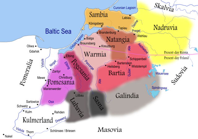
| 描述 | Map of Prussian clans during the 13th century. Areas shaded in grey reached further south than shown on this map. Prussian clans of Galindians, Sudovians, Sasna and Lubavia as well as Kulmerland had become subjected to numerous incursions and conquests by recently arriving Slavs. |
| 日期 | |
| 來源 | Self-made using Inkscape (see below for full discussion) |
| 作者 | Renata3 |
| 其他版本 |
|
For background I used: Image:LithuaniaPhysicalMap-Clean.svg by user:Knutux. For consistency, German names were used for cities/castles, rivers and lakes. Tribes/clans were named by their most common English names. Note that all boundaries (including rivers and lakes) are approximate. Shoreline was depicted as it is today (it has changed significantly from the 13th century).
Sources:
- Main: Map used to illustrate article on Prussians in Encyclopedia Lithuanica, volume IV, page 367. It generally agrees with Map by Marija Gimbutas published in The Balts (1963).
- Other: Map from National Museum of Lithuania and maps presented in William Urban (2000). The Prussian Crusade, ISBN 0-929700-28-7
A quite different map is presented in Bojtár, Endre (1999). Foreword to the Past: A Cultural History of the Baltic People. CEU Press, 159. ISBN 963-9116-42-4
授權條款
[編輯]
I, Renata3,此作品的版權所有人,決定用以下授權條款發佈本作品:

|
已授權您依據自由軟體基金會發行的無固定段落、封面文字和封底文字GNU自由文件授權條款1.2版或任意後續版本,對本檔進行複製、傳播和/或修改。該協議的副本列在GNU自由文件授權條款中。 |
| 此檔案採用創用CC 姓名標示-相同方式分享 3.0 未在地化版本授權條款。 | ||
| 姓名標示: I, Renata3 | ||
| ||
| 已新增授權條款標題至此檔案,作為GFDL授權更新的一部份。 |
您可以選擇您需要的授權條款。
檔案歷史
點選日期/時間以檢視該時間的檔案版本。
| 日期/時間 | 縮圖 | 尺寸 | 使用者 | 備註 | |
|---|---|---|---|---|---|
| 目前 | 2008年4月6日 (日) 20:38 | | 900 × 634(353 KB) | Renata3(留言 | 貢獻) | resolution |
| 2008年4月6日 (日) 20:35 |  | 529 × 372(159 KB) | Renata3(留言 | 貢獻) | masovia | |
| 2007年7月15日 (日) 22:55 |  | 991 × 713(399 KB) | Renata3(留言 | 貢獻) | change colors and name for Sasna | |
| 2007年7月14日 (六) 18:34 |  | 1,012 × 728(412 KB) | Renata3(留言 | 貢獻) | er... reduce size | |
| 2007年7月14日 (六) 18:31 |  | 2,029 × 1,455(1.08 MB) | Renata3(留言 | 貢獻) | add more river names, insculde Sassen | |
| 2007年6月11日 (一) 00:43 |  | 989 × 722(387 KB) | Renata3(留言 | 貢獻) | {{Information |Description=Map of Prussian clans during the 13th century |Source=Self-made using Inkscape |Date=2007-07-10 |Author= Renata3 }} For background I used: Image:LithuaniaPhysicalMap-Clean.svg by user:Knutux. Sources |
無法覆蓋此檔案。
檔案用途
下列頁面有用到此檔案:
全域檔案使用狀況
以下其他 wiki 使用了這個檔案:
- an.wikipedia.org 的使用狀況
- ar.wikipedia.org 的使用狀況
- bat-smg.wikipedia.org 的使用狀況
- ba.wikipedia.org 的使用狀況
- be-tarask.wikipedia.org 的使用狀況
- be.wikipedia.org 的使用狀況
- bg.wikipedia.org 的使用狀況
- ca.wikipedia.org 的使用狀況
- ce.wikipedia.org 的使用狀況
- csb.wikipedia.org 的使用狀況
- cs.wikipedia.org 的使用狀況
- da.wikipedia.org 的使用狀況
- dsb.wikipedia.org 的使用狀況
- el.wikipedia.org 的使用狀況
- en.wikipedia.org 的使用狀況
檢視此檔案的更多全域使用狀況。