File:Pub161-pgIV.jpg
跳至導覽
跳至搜尋

預覽大小:486 × 600 像素。 其他解析度:194 × 240 像素 | 389 × 480 像素 | 770 × 950 像素。
原始檔案 (770 × 950 像素,檔案大小:108 KB,MIME 類型:image/jpeg)
說明
說明
添加單行說明來描述出檔案所代表的內容
摘要
[編輯]
| 描述 |
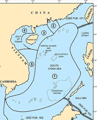
Map of the w:South China Sea region showing the areas covered by NGA Pub. 161, Sailing Directions (Enroute) South China Sea and the Gulf of Thailand, Fifteenth Edition, 2014 |
| 日期 | |
| 來源 |
Page IV of http://msi.nga.mil/MSISiteContent/StaticFiles/NAV_PUBS/SD/Pub161/Pub161bk.pdf |
| 作者 |
National Geospatial-Intelligence Agency (NGA), |
| 授權許可 (重用此檔案) |
© COPYRIGHT 2014 BY THE UNITED STATES GOVERNMENT NO COPYRIGHT CLAIMED UNDER TITLE 17 U.S.C. |
| 其他版本 |
 File:Pub161-pg1.jpg File:Pub161-pg1.jpg |
授權條款
[編輯]
此作品在美國屬於公有領域,因為其是由美國政府的官員或僱員,基於其個人公務目的製作的作品,參考美國法典第17篇第1章第105條。
注意︰本模板僅適用於美國聯邦政府的原創作品,不適用於任何美國州、屬地、聯邦個體、縣、市或任何次級政府的作品。本模板也不適用於1978年以後由美國郵政署出版的郵票圖案(參看美國版權局實踐綱領第313.6(C)(1)條)。也不適用於部分美國硬幣;參看美國鑄幣局使用條款。 |
 | |
| 此作品無已知的著作權限制,亦不受所有相關和鄰接的權利限制。 | ||
檔案歷史
點選日期/時間以檢視該時間的檔案版本。
| 日期/時間 | 縮圖 | 尺寸 | 用戶 | 備註 | |
|---|---|---|---|---|---|
| 目前 | 2014年11月30日 (日) 04:44 | | 770 × 950(108 KB) | Pdfpdf(對話 | 貢獻) | trim off top border (2 pixels) |
| 2014年11月30日 (日) 04:26 |  | 770 × 952(109 KB) | Pdfpdf(對話 | 貢獻) | {{Information |Description= Map of the w:South China Sea region showing the areas covered by NGA Pub. 161, ''Sailing Directions (Enroute) South China Sea and the Gulf of Thailand'', Fifteenth Edition, 2014 |Source=Page IV of http://msi.nga.mil/MSIS... |
無法覆蓋此檔案。
檔案用途
下列頁面有用到此檔案:
全域檔案使用狀況
以下其他 wiki 使用了這個檔案:
- en.wikipedia.org 的使用狀況
- fr.wikipedia.org 的使用狀況
- ur.wikipedia.org 的使用狀況
- vi.wikipedia.org 的使用狀況
- www.wikidata.org 的使用狀況
- zh.wikipedia.org 的使用狀況