File:Punjab district map.png
跳至導覽
跳至搜尋

預覽大小:540 × 600 像素。 其他解析度:216 × 240 像素 | 432 × 480 像素 | 691 × 768 像素 | 922 × 1,024 像素 | 2,467 × 2,741 像素。
原始檔案 (2,467 × 2,741 像素,檔案大小:635 KB,MIME 類型:image/png)
說明
說明
添加單行說明來描述出檔案所代表的內容

|
本圖片是以PNG、GIF或JPEG格式上傳。然而,其中包含的資料或訊息,應該重新建立成可縮放向量圖形(SVG)檔案,以更有效率或更準確的方式儲存。如有可能,請上傳本圖片的SVG格式版本。在上傳之後,請修改維基各姊妹計畫中所有使用舊版圖片的條目(列在圖像連結章節中),替換為新版圖片,並在舊圖片的描述頁中加入{{Vector version available|新圖片名稱.svg}}模板,同時移除本模板。
|
摘要
[編輯]
| 描述 |
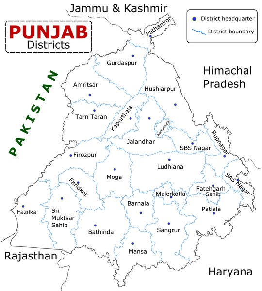
English: State of Punjab (Indian Punjab) with districts marked along with district Headquarters. |
| 日期 | |
| 來源 | Self made using Inkscape. Source map referred from Punjab govt. site. |
| 作者 | Wikigringo |
授權條款
[編輯]
我,本作品的著作權持有者,決定用以下授權條款發佈本作品:

|
已授權您依據自由軟體基金會發行的無固定段落、封面文字和封底文字GNU自由文件授權條款1.2版或任意後續版本,對本檔進行複製、傳播和/或修改。該協議的副本列在GNU自由文件授權條款中。 |
This file is licensed under the Creative Commons Attribution-Share Alike Attribution-Share Alike 4.0 International, 3.0 Unported, 2.5 Generic, 2.0 Generic and 1.0 Generic license.
- 您可以自由:
- 分享 – 複製、發佈和傳播本作品
- 重新修改 – 創作演繹作品
- 惟需遵照下列條件:
- 姓名標示 – 您必須指名出正確的製作者,和提供授權條款的連結,以及表示是否有對內容上做出變更。您可以用任何合理的方式來行動,但不得以任何方式表明授權條款是對您許可或是由您所使用。
- 相同方式分享 – 如果您利用本素材進行再混合、轉換或創作,您必須基於如同原先的相同或兼容的條款,來分布您的貢獻成品。
您可以選擇您需要的授權條款。
檔案歷史
點選日期/時間以檢視該時間的檔案版本。
| 日期/時間 | 縮圖 | 尺寸 | 用戶 | 備註 | |
|---|---|---|---|---|---|
| 目前 | 2023年1月10日 (二) 09:25 | | 2,467 × 2,741(635 KB) | Saad Ali Khan Pakistan(對話 | 貢獻) | updated district MalerKotla on map |
| 2020年7月7日 (二) 04:45 |  | 2,467 × 2,741(867 KB) | Kaushal Bishnoi(對話 | 貢獻) | New Update version of Punjab District Map with 22 District. | |
| 2013年10月5日 (六) 14:41 |  | 1,094 × 848(127 KB) | Ras67(對話 | 貢獻) | cropped and optimized | |
| 2008年4月28日 (一) 08:40 |  | 1,211 × 874(187 KB) | Wikigringo(對話 | 貢獻) | Uploading a better color version of the file with bigger font size. | |
| 2008年4月26日 (六) 16:01 |  | 1,269 × 907(167 KB) | Wikigringo(對話 | 貢獻) | {{Information |Description=State of Punjab, India with districts marked along with district HQ. |Source=Self made using Inkscape. Source map referred from Punjab govt. site. |Date=04/26/2008 |Author=Wikigringo |Permission= |other_versions= }} |
無法覆蓋此檔案。
檔案用途
下列5個頁面有用到此檔案:
全域檔案使用狀況
以下其他 wiki 使用了這個檔案:
- ar.wikipedia.org 的使用狀況
- azb.wikipedia.org 的使用狀況
- bh.wikipedia.org 的使用狀況
- bn.wikipedia.org 的使用狀況
- ca.wikipedia.org 的使用狀況
- ceb.wikipedia.org 的使用狀況
- en.wikipedia.org 的使用狀況
- es.wikipedia.org 的使用狀況
- eu.wikipedia.org 的使用狀況
- fa.wikipedia.org 的使用狀況
- fi.wikipedia.org 的使用狀況
- fr.wikipedia.org 的使用狀況
- Pendjab (Inde)
- District de Barnala
- District de Faridkot
- District de Fatehgarh Sahib
- District de Fazilka
- District de Firozpur
- District de Gurdaspur
- District de Hoshiarpur
- District de Jalandhar
- District de Kapurthala
- District de Ludhiana
- District de Mansa (Penjab)
- District de Moga
- District de Mohali
- District de Muktsar
檢視此檔案的更多全域使用狀況。