File:Pusan Perimeter (zh-hans).jpg
跳转到导航
跳转到搜索
没有更高的分辨率。
Pusan_Perimeter_(zh-hans).jpg (350 × 572像素,文件大小:72 KB,MIME类型:image/jpeg)
说明
说明
添加一行文字以描述该文件所表现的内容
摘要[编辑]
| 描述 |
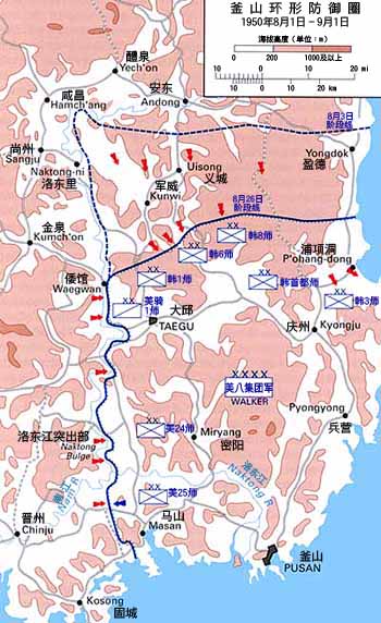
English: Map of the Pusan Perimeter, August 1950. |
| 日期 | |
| 来源 |
English: This map was created by the Center for Military History and used in the brochure "The Korean War: The Outbreak" located at [1].
Localization work of:
|
| 作者 |

.jpg&action=edit§ion=1)
许可协议[编辑]
.jpg&action=edit§ion=2)
| This image is in the public domain because it contains materials that originally came from the United States Army Center of Military History, subject to the following qualification.
Note: The images of all badges, insignia, decorations and medals on the "CMH Online" web site are produced by the United States Army Institute of Heraldry and protected by Title 18, United States Code, Section 704 and the Code of Federal Regulations (32 CFR, Part 507). Permission to use these images for commercial purposes must be obtained from The Institute of Heraldry prior to their use. |

|
文件历史
点击某个日期/时间查看对应时刻的文件。
| 日期/时间 | 缩略图 | 大小 | 用户 | 备注 | |
|---|---|---|---|---|---|
| 当前 | 2016年9月21日 (三) 15:27 | | 350 × 572(72 KB) | Howard61313(留言 | 贡献) | Modified |
| 2016年9月21日 (三) 15:16 |  | 350 × 572(73 KB) | Howard61313(留言 | 贡献) | User created page with UploadWizard |
您不可以覆盖此文件。
文件用途
以下3个页面使用本文件:
全域文件用途
以下其他wiki使用此文件:
- zh.wikipedia.org上的用途
.jpg&oldid=388326990)