File:Pusan Perimeter (zh-hans).jpg
跳至導覽
跳至搜尋
無更高解析度可提供。
Pusan_Perimeter_(zh-hans).jpg (350 × 572 像素,檔案大小:72 KB,MIME 類型:image/jpeg)
說明
說明
添加單行說明來描述出檔案所代表的內容
摘要[編輯]
| 描述 |
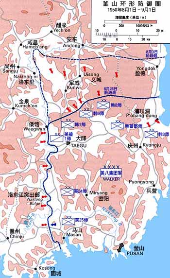
English: Map of the Pusan Perimeter, August 1950. |
| 日期 | |
| 來源 |
English: This map was created by the Center for Military History and used in the brochure "The Korean War: The Outbreak" located at [1].
Localization work of:
|
| 作者 |

.jpg&action=edit§ion=1)
授權條款[編輯]
.jpg&action=edit§ion=2)
| This image is in the public domain because it contains materials that originally came from the United States Army Center of Military History, subject to the following qualification.
Note: The images of all badges, insignia, decorations and medals on the "CMH Online" web site are produced by the United States Army Institute of Heraldry and protected by Title 18, United States Code, Section 704 and the Code of Federal Regulations (32 CFR, Part 507). Permission to use these images for commercial purposes must be obtained from The Institute of Heraldry prior to their use. |

|
檔案歷史
點選日期/時間以檢視該時間的檔案版本。
| 日期/時間 | 縮圖 | 尺寸 | 使用者 | 備註 | |
|---|---|---|---|---|---|
| 目前 | 2016年9月21日 (三) 15:27 | | 350 × 572(72 KB) | Howard61313(留言 | 貢獻) | Modified |
| 2016年9月21日 (三) 15:16 |  | 350 × 572(73 KB) | Howard61313(留言 | 貢獻) | User created page with UploadWizard |
無法覆蓋此檔案。
檔案用途
下列3個頁面有用到此檔案:
全域檔案使用狀況
以下其他 wiki 使用了這個檔案:
- zh.wikipedia.org 的使用狀況
.jpg&oldid=388326990)