File:Quebec 1608 Champlain.PNG

Fitxer original (1.500 × 929 píxels, mida del fitxer: 1,09 Mo, tipus MIME: image/png)
Llegendes
Llegendes
Resum
[modifica]
| Descripció |
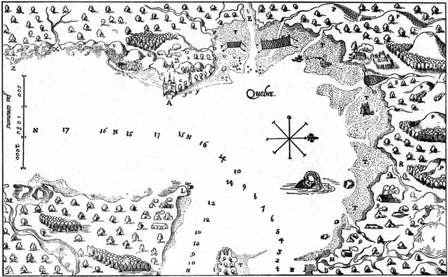
Français : Carte de la région de Québec, par Champlain, 1608
Les chiffres montrent les brasses d'eau. A Le lieu où l'habitation est bastie. B Terre deffrichée où l'on seme du bled & autres grains. C Les jardinages. D Petit ruisseau qui vient de dedans des marescages. E Riviere où hyverna Jaques Quartier, qui de son temps la nomma saincte Croix, que l'on a transféré à 15. lieues audessus de Quebec. F Ruisseau des marais. G Le lieu où l'on amassoit les herbages pour le bestail que l'on y avoit mené. H Le grand saut de Montmorency qui descent de plus de 25. brasses de haut dans la riviere. I Bout de l'isle d'Orlans. L Pointe fort estroite du costé de l'orient de Quebecq. M Riviere bruyante, qui va aux Etechemains. N La grande riviere S. Laurens. O Lac de la riviere bruyante. P Montaignes qui sont dans les terres ; baye que j'ai nommé la nouvelle Bisquaye. Q Lac du grand saut de Montmorency R Ruisseau de lours. S Ruisseau du Gendre. T Prairies qui sont inondées des eaux à toutes les marées. V Mont du Gas fort haut, sur le bort de la riviere. X Ruisseau courant, propre à faire toutes sortes de moulins. Y Coste de gravier, où il se trouve quantité de diamants un peu meilleurs que ceux d'Alenson. Z La pointe aux diamants. 9 Lieux où souvent cabannent les sauvages.English: Map of Quebec region, by Champlain, 1608
The figures show the fathoms of water A The Site where the Settlement is buit. B Cleared Land where Wheat and other Grains are Sown. C The Gardens. D Small Stream flowing from among the Swamps E River where wintered Jacques Cartier, who then named it Ste. Croix, which was transferred 15 leages above Quebec. F Stream from the Marshes. G The Place where Hay was Collected for the Live Stock that had been brought hither. H The great Montmorency Falls which Descend from a Height of more than 25 Fathoms into the River. I End of the Island of Orleans. L Very Sharp Point on the Shore to the East of Quebec. M Boisterous River leading to the Etchemins. N The great River St. Lawrence. O Lake of the Boisterous River. P Mointains in the distance : Bay which I named New Biscay. Q Lake of the great Montmorency Falls. R Bear River. S Son-in-Law River. T Flats which are Covered at every Tide. V Du Gas Mountain very high on the Bank of the River. X Flowing Stream Suitable to Work every Kind of Mill. Y Gravel Bank where one finds quantities of Diamonds slightly better than those of Alençon. Z Diamond Point. 9 Place where the Savages Frequently Encamp. |
| Data | |
| Font | Numérisation d'une page du livre : Œuvres de Champlain, présenté par Georges-Émile Giguère, Éditions du Jour, Montréal, 1973, vol. 1, p. 149 |
| Autor | Samuel de Champlain |
Llicència
[modifica]
| Jo, el titular del copyright d'aquesta obra, l'allibero al domini públic. Això s'aplica a tot el món. En alguns països això pot no ser legalment possible, en tal cas: Jo faig concessió a tothom del dret d'usar aquesta obra per a qualsevol propòsit, sense cap condició llevat d'aquelles requerides per la llei. |
Historial del fitxer
Cliqueu una data/hora per veure el fitxer tal com era aleshores.
| Data/hora | Miniatura | Dimensions | Usuari/a | Comentari | |
|---|---|---|---|---|---|
| actual | 22:47, 20 abr 2010 | | 1.500 × 929 (1,09 Mo) | Jeangagnon (discussió | contribucions) | {{Information |Description={{en|1=Map of Quebec region, by Champlain, 1608}} {{fr|1=Carte de la région de Québec, par Champlain, 1608}} |Source=Numérisation d'une page du livre : Œuvres de Champlain, présenté par Georges-Émile Giguère, Éditions d |
No podeu sobreescriure aquest fitxer.
Ús del fitxer
No hi ha pàgines que utilitzin aquest fitxer.
Ús global del fitxer
Utilització d'aquest fitxer en altres wikis:
- Utilització a ca.wikipedia.org
- Utilització a fr.wikipedia.org