File:Race to Deir ezzor.svg
跳转到导航
跳转到搜索

此SVG文件的PNG预览的大小:800 × 500像素。 其他分辨率:320 × 200像素 | 640 × 400像素 | 1,024 × 640像素 | 1,280 × 800像素 | 2,560 × 1,600像素 | 1,440 × 900像素。
原始文件 (SVG文件,尺寸为1,440 × 900像素,文件大小:7.49 MB)
说明
说明
添加一行文字以描述该文件所表现的内容
摘要
[编辑]
| 描述 |
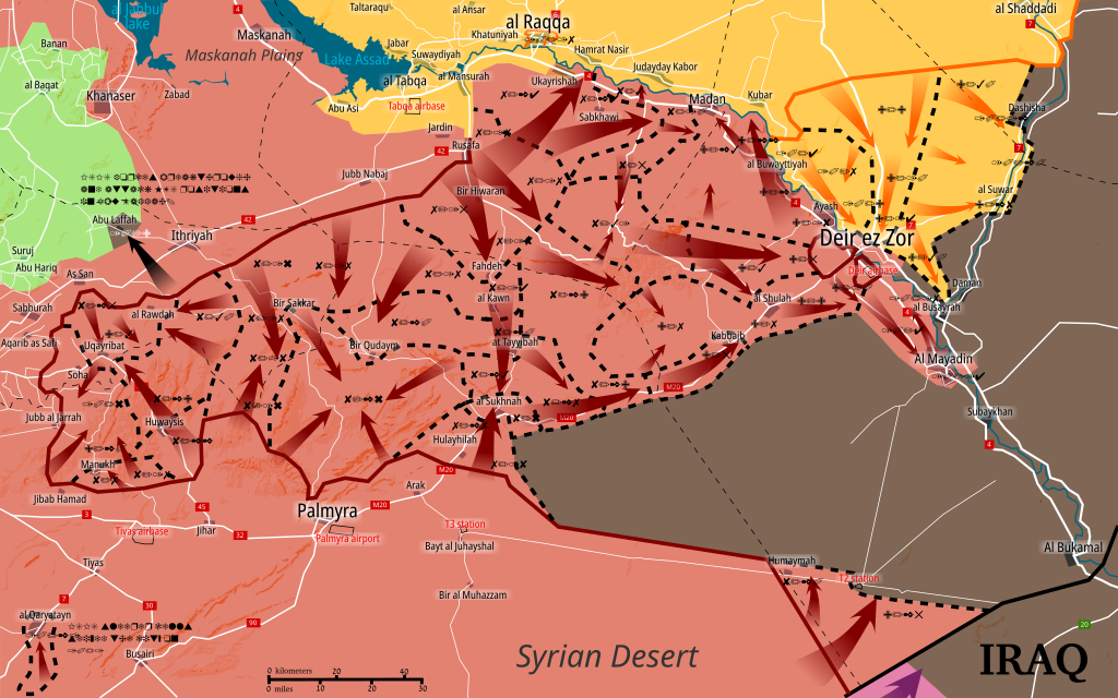
English: Situation of central Syria between July 14 - present. Map shows the advancements during the Central Syrian offensive. Made in Inkscape and influenced by many maps from creators: PetoLucem, A7_Mirza, SouthFront, and MrPenguin20.
Controlled by the Syrian Arab Republic
Controlled by the Syrian opposition
Controlled by the Syrian Democratic Forces
Controlled by the Islamic State of Iraq and the Levant (ISIL, ISIS, IS, Daesh)
Controlled by the Iraqi government |
| 日期 | |
| 来源 | 自己的作品 |
| 作者 | Rr016 |
许可协议
[编辑]
我,本作品著作权人,特此采用以下许可协议发表本作品:
本文件采用知识共享署名-相同方式共享 4.0 国际许可协议授权。
- 您可以自由地:
- 共享 – 复制、发行并传播本作品
- 修改 – 改编作品
- 惟须遵守下列条件:
- 署名 – 您必须对作品进行署名,提供授权条款的链接,并说明是否对原始内容进行了更改。您可以用任何合理的方式来署名,但不得以任何方式表明许可人认可您或您的使用。
- 相同方式共享 – 如果您再混合、转换或者基于本作品进行创作,您必须以与原先许可协议相同或相兼容的许可协议分发您贡献的作品。
文件历史
点击某个日期/时间查看对应时刻的文件。
| 日期/时间 | 缩略图 | 大小 | 用户 | 备注 | |
|---|---|---|---|---|---|
| 当前 | 2017年10月22日 (日) 17:11 | | 1,440 × 900(7.49 MB) | Rr016(留言 | 贡献) | Added recapture of Qaryatayn and other details on the map as per LightandDark2000's request. |
| 2017年10月21日 (六) 19:21 |  | 1,440 × 900(7.48 MB) | Rr016(留言 | 贡献) | Central Syria Campaign is over. Map is finished. | |
| 2017年10月10日 (二) 12:37 |  | 1,440 × 900(7.48 MB) | Rr016(留言 | 贡献) | Strange update: ISIS is now attacking HTS positions north of al San? Not sure how they got there. | |
| 2017年10月8日 (日) 20:42 |  | 1,440 × 900(7.47 MB) | Rr016(留言 | 贡献) | Small update: ISIS east Hama pocket completely taken by SAA, SDF are advancing along Euphrates. | |
| 2017年10月4日 (三) 20:36 |  | 1,440 × 900(7.47 MB) | Rr016(留言 | 贡献) | Update: east Hama pocket shrinking, SAA advancing towards Mayadin, SDF captures al Suwar, Jafra oil fields, and are advancing along Euphrates. | |
| 2017年9月23日 (六) 18:58 |  | 1,440 × 900(7.46 MB) | Rr016(留言 | 贡献) | Updates and fixes: SAA clears Maadan Euphrates area and crossed the river. SDF is advancing east towards oil wells. Removed some arrows and lines - too much. Also Iraqi forces are moving along their border. | |
| 2017年9月10日 (日) 17:51 |  | 1,440 × 900(7.46 MB) | Rr016(留言 | 贡献) | Update and fixes: SDF has reached Deir ez Zor industrial zone, SAA secured Shoula-Deir road. Removed some dashed lines, there's a bit too much on this map. | |
| 2017年9月10日 (日) 12:55 |  | 1,440 × 900(7.46 MB) | Rr016(留言 | 贡献) | Big update: SAA lifts Deir airbase siege and SDF are pushing south towards Deir ez Zor. | |
| 2017年9月5日 (二) 19:15 |  | 1,440 × 900(7.44 MB) | Rr016(留言 | 贡献) | Siege of Deir ez Zor has been lifted. Uqayribat captured by SAA. | |
| 2017年9月1日 (五) 16:46 |  | 1,440 × 900(7.43 MB) | Rr016(留言 | 贡献) | Update - Uqayribat pocket is being taken by SAA. SAA advance east of al Sukhnah reaching Deir ez Zor governorate. |
您不可以覆盖此文件。
文件用途
以下5个页面使用本文件:
全域文件用途
以下其他wiki使用此文件:
- ar.wikipedia.org上的用途
- be.wikipedia.org上的用途
- en.wikipedia.org上的用途
- es.wikipedia.org上的用途
- fa.wikipedia.org上的用途
- fr.wikipedia.org上的用途
- fr.wikinews.org上的用途
- it.wikipedia.org上的用途
- pl.wikipedia.org上的用途
- pt.wikipedia.org上的用途
- ru.wikipedia.org上的用途
- www.wikidata.org上的用途
- zh.wikipedia.org上的用途