File:Radar of the Quad-State Supercell prior to impacting Mayfield, Kentucky.png
Zur Navigation springen
Zur Suche springen

Größe dieser Vorschau: 680 × 600 Pixel. Weitere Auflösungen: 272 × 240 Pixel | 544 × 480 Pixel | 871 × 768 Pixel | 1.161 × 1.024 Pixel | 1.437 × 1.267 Pixel.
Originaldatei (1.437 × 1.267 Pixel, Dateigröße: 1,75 MB, MIME-Typ: image/png)
Bildtexte
Kurzbeschreibungen
Ergänze eine einzeilige Erklärung, was diese Datei darstellt.
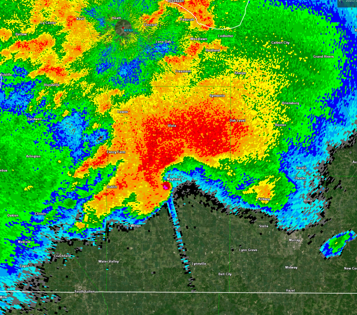
NEXRAD radar of the Quad-State Supercell from KPAH. This is the 2021 Western Kentucky tornado prior to impacting Mayfield, Kentucky.
Beschreibung[Bearbeiten]
| Beschreibung |
English: NEXRAD Reflectivity radar of the Quad-State Supercell from KPAH. This is the 2021 Western Kentucky tornado (seen via the hook echo) prior to impacting the city of Mayfield, Kentucky with winds estimated to be at least 188 miles per hour (303 km/h). The long “line” to the south-southeast is a debris spike caused by debris lofted by the tornado. |
| Datum | |
| Quelle | NEXRAD KPAH |
| Urheber | National Weather Service |
Lizenz[Bearbeiten]
This image is in the public domain because it is from one or more of the U.S. government’s 159 NEXRAD radars, which are jointly owned and operated by the National Weather Service (NWS), an agency of the National Oceanic and Atmospheric Administration (NOAA) within the United States Department of Commerce, the Federal Aviation Administration (FAA) within the Department of Transportation, and the U.S. Air Force within the Department of Defense.
Thus all NEXRAD images are public domain.
|
  |
Dateiversionen
Klicke auf einen Zeitpunkt, um diese Version zu laden.
| Version vom | Vorschaubild | Maße | Benutzer | Kommentar | |
|---|---|---|---|---|---|
| aktuell | 01:51, 2. Nov. 2022 | | 1.437 × 1.267 (1,75 MB) | WeatherWriter (Diskussion | Beiträge) | Uploaded own work with UploadWizard |
Du kannst diese Datei nicht überschreiben.
Dateiverwendung
Keine Seiten verwenden diese Datei.
Globale Dateiverwendung
Die nachfolgenden anderen Wikis verwenden diese Datei:
- Verwendung auf de.wikipedia.org
- Verwendung auf en.wikipedia.org