File:Rail gauge world.svg
跳转到导航
跳转到搜索

此SVG文件的PNG预览的大小:800 × 406像素。 其他分辨率:320 × 162像素 | 640 × 325像素 | 1,024 × 520像素 | 1,280 × 650像素 | 2,560 × 1,300像素 | 2,754 × 1,398像素。
原始文件 (SVG文件,尺寸为2,754 × 1,398像素,文件大小:1.05 MB)
说明
说明
添加一行文字以描述该文件所表现的内容
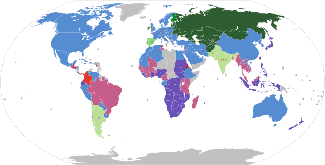
Map of global track gauges
Any autoconfirmed user can overwrite this file from the same source. Please ensure that overwrites comply with the guideline.
摘要
[编辑]| 描写 |
English: Shows the railroad gauge which is currently most used in each country (main colour), with other significant gauges used depicted as small squares on top of the main colour. Grey indicates no railways.
Español: Muestra el ancho de vía más comunmente usado en cada país (color principal), con otros anchos representados con pequeños cuadrados sobre el color principal. El color gris indica que no existen vías férreas en el territorio.
Français : Montre l'écartement le plus utilisé dans chaque pays (couleur principale), les autres écartements significatifs sont illustrés par des petits carrés superposés sur la couleur principale. Le gris indique l'absence de chemins de fer.
Русский: Ширина колеи железных дорог, используемая в настоящее время наиболее часто в разных странах (основной цвет). Прочие используемые ширины колеи изображены в виде маленьких квадратиков поверх основного цвета. Серый цвет — отсутствие железных дорог.
中文:图中各国的主色表示该国最通用的铁路轨距,小色块代表其他重要的轨距,灰色则为尚无铁路的国家 |
| 地图图例 |
597毫米、600毫米、603毫米、610毫米(两英尺)
750毫米,760毫米波斯尼亚,762毫米(2英尺 6英寸),800毫米
891毫米瑞典,900毫米,914毫米(三英尺)
1000毫米(米)
1067毫米(三英尺六英寸)
1372毫米(四英尺六英寸)
1435毫米标准
1520毫米俄罗斯标准
1524毫米老俄罗斯标准(五英尺)
1600毫米(五英尺三英寸)
1668毫米伊比利亚
1676毫米(五英尺六英寸)
1829毫米(六英尺),2140毫米布鲁内尔 |
| SVG开发 | |
| 日期 | |
| 来源 | Made using the list on CIA Factbook railways, Seabhcan's railmap and OpenRailwayMap. Uses BlankMap-World.svg |
| 创作作者 |
selfmade |
| 地理参考 | 如果不适当,请设置 warp_status = skip 为隐藏。 |
| 其他版本 | PNG version (outdated), SVG version with legend (current) |


许可协议
[编辑]
我,本作品著作权人,特此采用以下许可协议发表本作品:

|
已授权您依据自由软件基金会发行的无固定段落及封面封底文字(Invariant Sections, Front-Cover Texts, and Back-Cover Texts)的GNU自由文件许可协议1.2版或任意后续版本的条款,复制、传播和/或修改本文件。该协议的副本请见“GNU Free Documentation License”。 |
| 本文件采用知识共享署名-相同方式共享 3.0 未本地化版本许可协议授权。 | ||
| ||
| 本许可协议标签作为GFDL许可协议更新的组成部分被添加至本文件。 |
文件历史
点击某个日期/时间查看对应时刻的文件。
| 日期/时间 | 缩略图 | 大小 | 用户 | 备注 | |
|---|---|---|---|---|---|
| 当前 | 2024年1月19日 (五) 22:55 | | 2,754 × 1,398(1.05 MB) | Rtfroot(留言 | 贡献) | Mauritius metro (1435mm), Indonesia high speed line (1435mm) |
| 2023年11月18日 (六) 22:53 |  | 2,754 × 1,398(1.05 MB) | Akeosnhaoe(留言 | 贡献) | Sakhalin | |
| 2023年9月25日 (一) 10:02 |  | 2,754 × 1,398(1.05 MB) | Akeosnhaoe(留言 | 贡献) | Tunisia | |
| 2023年7月16日 (日) 14:00 |  | 2,754 × 1,398(1.05 MB) | Wikkiwonkk(留言 | 贡献) | added Cape gauge to Lesotho (small spur connecting to South Africa's network); removed Inkscape/Sodipodi cruft | |
| 2023年3月11日 (六) 03:50 |  | 2,754 × 1,398(1.06 MB) | Wikkiwonkk(留言 | 贡献) | added standard gauge to Tanzania | |
| 2023年3月11日 (六) 03:46 |  | 2,754 × 1,398(1.1 MB) | Wikkiwonkk(留言 | 贡献) | Reverted to version as of 18:14, 12 September 2022 (UTC) - svg2png tool doesn't work with CSS colours as variables! *cries* | |
| 2023年3月11日 (六) 03:43 |  | 2,754 × 1,398(1.06 MB) | Wikkiwonkk(留言 | 贡献) | reverted the file structure back to the hand editable version, but incorporating the recent Tanzania change; changed all the colours to be named variables to make future edits easier | |
| 2023年3月8日 (三) 18:55 |  | 2,754 × 1,398(3.39 MB) | Rtfroot(留言 | 贡献) | added Tanzania standard gauge (The first phase Dar es Salaam–Morogoro Section has been completed in April 2022 currently in live testing phase) | |
| 2022年9月12日 (一) 18:14 |  | 2,754 × 1,398(1.1 MB) | Delusion23(留言 | 贡献) | Isle of Man railways are narrow gauge | |
| 2022年7月24日 (日) 20:10 |  | 2,754 × 1,398(1.06 MB) | Виталий Болбас(留言 | 贡献) | Fixed Afghanistan |
您不可以覆盖此文件。
文件用途
以下75个页面使用本文件:
- User:Chumwa/OgreBot/Potential transport maps/2016 July 11-20
- User:Chumwa/OgreBot/Potential transport maps/2016 July 21-31
- User:Chumwa/OgreBot/Potential transport maps/2016 September 21-30
- User:Chumwa/OgreBot/Potential transport maps/2017 July 11-20
- User:Chumwa/OgreBot/Potential transport maps/2018 October 11-20
- User:Chumwa/OgreBot/Potential transport maps/2019 April 1-10
- User:Chumwa/OgreBot/Potential transport maps/2019 November 21-30
- User:Chumwa/OgreBot/Potential transport maps/2019 September 1-10
- User:Chumwa/OgreBot/Potential transport maps/2020 January 1-10
- User:Chumwa/OgreBot/Public transport information/2016 July 11-20
- User:Chumwa/OgreBot/Public transport information/2016 July 21-31
- User:Chumwa/OgreBot/Public transport information/2016 September 21-30
- User:Chumwa/OgreBot/Public transport information/2017 July 11-20
- User:Chumwa/OgreBot/Public transport information/2018 October 11-20
- User:Chumwa/OgreBot/Public transport information/2019 April 1-10
- User:Chumwa/OgreBot/Public transport information/2019 November 21-30
- User:Chumwa/OgreBot/Public transport information/2019 September 1-10
- User:Chumwa/OgreBot/Public transport information/2020 January 1-10
- User:Chumwa/OgreBot/Public transport information/2020 July 11-20
- User:Chumwa/OgreBot/Public transport information/2020 June 1-10
- User:Chumwa/OgreBot/Public transport information/2020 May 1-10
- User:Chumwa/OgreBot/Public transport information/2021 December 1-10
- User:Chumwa/OgreBot/Public transport information/2021 December 21-31
- User:Chumwa/OgreBot/Public transport information/2021 March 21-31
- User:Chumwa/OgreBot/Public transport information/2022 January 21-31
- User:Chumwa/OgreBot/Public transport information/2022 July 21-31
- User:Chumwa/OgreBot/Public transport information/2022 June 1-10
- User:Chumwa/OgreBot/Public transport information/2022 March 21-31
- User:Chumwa/OgreBot/Public transport information/2022 May 1-10
- User:Chumwa/OgreBot/Public transport information/2022 September 11-20
- User:Chumwa/OgreBot/Public transport information/2023 July 11-20
- User:Chumwa/OgreBot/Public transport information/2023 March 1-10
- User:Chumwa/OgreBot/Public transport information/2023 March 11-20
- User:Chumwa/OgreBot/Public transport information/2023 November 11-20
- User:Chumwa/OgreBot/Public transport information/2023 September 21-30
- User:Chumwa/OgreBot/Public transport information/2024 January 11-20
- User:Chumwa/OgreBot/Transport Maps/2016 July 11-20
- User:Chumwa/OgreBot/Transport Maps/2016 July 21-31
- User:Chumwa/OgreBot/Transport Maps/2016 September 21-30
- User:Chumwa/OgreBot/Transport Maps/2017 July 11-20
- User:Chumwa/OgreBot/Transport Maps/2018 October 11-20
- User:Chumwa/OgreBot/Transport Maps/2019 April 1-10
- User:Chumwa/OgreBot/Transport Maps/2019 November 21-30
- User:Chumwa/OgreBot/Transport Maps/2019 September 1-10
- User:Chumwa/OgreBot/Transport Maps/2020 January 1-10
- User:Chumwa/OgreBot/Transport Maps/2020 July 11-20
- User:Chumwa/OgreBot/Transport Maps/2020 June 1-10
- User:Chumwa/OgreBot/Transport Maps/2020 May 1-10
- User:Chumwa/OgreBot/Transport Maps/2021 December 1-10
- User:Chumwa/OgreBot/Transport Maps/2021 December 21-31
- User:Chumwa/OgreBot/Transport Maps/2021 March 21-31
- User:Chumwa/OgreBot/Transport Maps/2022 January 21-31
- User:Chumwa/OgreBot/Transport Maps/2022 July 21-31
- User:Chumwa/OgreBot/Transport Maps/2022 June 1-10
- User:Chumwa/OgreBot/Transport Maps/2022 March 21-31
- User:Chumwa/OgreBot/Transport Maps/2022 May 1-10
- User:Chumwa/OgreBot/Transport Maps/2022 September 11-20
- User:Chumwa/OgreBot/Transport Maps/2023 July 11-20
- User:Chumwa/OgreBot/Transport Maps/2023 March 1-10
- User:Chumwa/OgreBot/Transport Maps/2023 March 11-20
- User:Chumwa/OgreBot/Transport Maps/2023 November 11-20
- User:Chumwa/OgreBot/Transport Maps/2023 September 21-30
- User:Chumwa/OgreBot/Transport Maps/2024 January 11-20
- User:Chumwa/OgreBot/Travel and communication maps/2016 July 11-20
- User:Chumwa/OgreBot/Travel and communication maps/2016 July 21-31
- User:Chumwa/OgreBot/Travel and communication maps/2016 September 21-30
- User:Chumwa/OgreBot/Travel and communication maps/2017 July 11-20
- User:Chumwa/OgreBot/Travel and communication maps/2018 October 11-20
- User:Chumwa/OgreBot/Travel and communication maps/2019 April 1-10
- User:Chumwa/OgreBot/Travel and communication maps/2019 September 1-10
- User:OgreBot/Watercraft/2016 September 22/Overflow 1
- Commons:Graphic Lab/Map workshop/Archive/2021
- Commons:Graphic Lab/Map workshop/Archive/2023
- File:Rail gauge world.png
- Category:Track gauge
全域文件用途
以下其他wiki使用此文件:
- ar.wikipedia.org上的用途
- bn.wikipedia.org上的用途
- da.wikipedia.org上的用途
- en.wikipedia.org上的用途
- Narrow-gauge railway
- Network effect
- Standard-gauge railway
- Broad-gauge railway
- Great Western Railway
- Track gauge
- Railway track
- European integration
- Metre-gauge railway
- Breitspurbahn
- Bering Strait crossing
- Break of gauge
- Rail freight transport
- 3 ft 6 in gauge railways
- Talk:San Diego Electric Railway
- Ten and a quarter inch gauge
- Minimum-gauge railway
- Baltimore Streetcar Museum
- 5 ft and 1520 mm gauge railways
- Variable gauge
- Template:Track gauge sidebar
- Decauville
- List of track gauges
- 4 ft 6 in gauge railway
- Narrow-gauge railways in Canada
- Narrow-gauge railroads in the United States
- Bogie exchange
- Track gauge conversion
- List of 2 ft 3 in gauge railways
- Track gauge in Ireland
- 5 ft 3 in gauge railways
- 5 ft 6 in gauge railway
- Iberian-gauge railways
- Track gauge in Canada
- Track gauge in South America
- Track gauge in Europe
- List of gauge conversions
- Track gauge in North America
- Trams in Dresden
- Bosnian-gauge railways
- Track gauge in Italy
查看此文件的更多全域用途。