File:Rajendra map new.svg

Fichier d’origine (Fichier SVG, nominalement de 466 × 333 pixels, taille : 220 kio)
Légendes
Légendes
Description[modifier]
| Description |
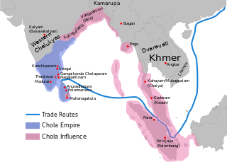
per http://cw.routledge.com/textbooks/9780415485432/15.asp "THE CŌḶAS" by K. A. Nilakanta Sastri and other histories of South Asia consulted.
The file has several changes from the original. The map is corrected to show are of influence and direct control in Sri Lanka. Correction was based on the work of Spencer, G. (1976). The Politics of Plunder: The Cholas in Eleventh-Century Ceylon. The Journal of Asian Studies, 35(3), 405-419. doi:10.2307/2053272. The correction about the Chola influence in Malay areas is based on https://archive.org/details/earlykingdomsofi0000muno/page/118/mode/2up The influence added the area of Lamuri based on Tanjore inscription. Andaman is deleted leaving only Nicobar (information on Tanjore inscription). |
| Date | (UTC) |
| Source | |
| Auteur |
|
| Cette image a été retouchée, ce qui signifie qu'elle a été modifiée par ordinateur et est différente de l'image d'origine. Liste des modifications : Redrew png as svg. L'image d'origine se trouve ici : Rajendra map new.png:
|
| Ce fichier est disponible selon les termes de la licence Creative Commons Attribution – Partage dans les Mêmes Conditions 3.0 (non transposée). Sujet aux avertissements. | ||
| ||
| Ce bandeau de licence a été ajouté à ce fichier dans le cadre de la procédure de mise à jour des licences des images sous GFDL. |

|
Vous avez la permission de copier, distribuer et modifier ce document selon les termes de la GNU Free Documentation License version 1.2 ou toute version ultérieure publiée par la Free Software Foundation, sans sections inaltérables, sans texte de première page de couverture et sans texte de dernière page de couverture. Un exemplaire de la licence est inclus dans la section intitulée GNU Free Documentation License. |
Journal des téléversements d’origine[modifier]
This image is a derivative work of the following images:
- File:Rajendra_map_new.png licensed with Cc-by-sa-3.0-migrated-with-disclaimers, GFDL-en, GFDL-user-en-with-disclaimers
- 2011-03-21T12:16:23Z Gregors 600x429 (102117 Bytes) Bitmap of svg that i will soon upload. ~~~~
- 2009-06-07T09:04:06Z Maukie 629x442 (215021 Bytes) {{Information |Description={{en|Map showing the extent of the [[:en:Chola empire|]] during [[:en:Rajendra Chola I|]] (c. 1030 CE)}} |Source=Transferred from [http://en.wikipedia.org en.wikipedia]; transfer was stated to be ma
Téléversé avec derivativeFX
Historique du fichier
Cliquer sur une date et heure pour voir le fichier tel qu'il était à ce moment-là.
| Date et heure | Vignette | Dimensions | Utilisateur | Commentaire | |
|---|---|---|---|---|---|
| actuel | 24 mai 2024 à 03:54 | | 466 × 333 (220 kio) | SKAG123 (d | contributions) | Reverted to version as of 15:53, 12 May 2024 (UTC) Vandalism |
| 20 mai 2024 à 17:33 |  | 466 × 333 (189 kio) | Tirukodimadachengunrur (d | contributions) | Reverted to version as of 05:36, 11 May 2024 (UTC) | |
| 12 mai 2024 à 15:53 |  | 466 × 333 (220 kio) | SKAG123 (d | contributions) | Reverted to version as of 16:27, 6 May 2024 (UTC) | |
| 11 mai 2024 à 05:36 |  | 466 × 333 (189 kio) | Ranithraj (d | contributions) | Reverted to version as of 07:21, 1 May 2024 (UTC) | |
| 6 mai 2024 à 16:27 |  | 466 × 333 (220 kio) | Editer1234566 (d | contributions) | Reverted to version as of 21:50, 21 December 2023 (UTC) | |
| 1 mai 2024 à 07:21 |  | 466 × 333 (189 kio) | Tirukodimadachengunrur (d | contributions) | Reverted to version as of 13:15, 17 December 2023 (UTC) | |
| 21 décembre 2023 à 21:50 |  | 466 × 333 (220 kio) | SKAG123 (d | contributions) | Reverted to version as of 05:56, 29 November 2023 (UTC) | |
| 17 décembre 2023 à 13:15 |  | 466 × 333 (189 kio) | Ranithraj (d | contributions) | Reverted to version as of 05:07, 25 November 2023 (UTC) | |
| 29 novembre 2023 à 05:56 |  | 466 × 333 (220 kio) | Surijeal (d | contributions) | Reverted to version as of 01:27, 25 November 2023 (UTC) Nonsense or unsubstantiated question, it does not give reasoning for revert | |
| 25 novembre 2023 à 05:07 |  | 466 × 333 (189 kio) | Indo12122 (d | contributions) | Reverted to version as of 06:39, 27 June 2022 (UTC) It just includes territories which were influenced by Sri vijaya. What about the other kingdoms and principalities? |
Vous ne pouvez pas remplacer ce fichier.
Utilisations locales du fichier
Les 28 pages suivantes utilisent ce fichier :
- User:Chumwa/OgreBot/Transport Maps/2021 January 21-31
- User:Chumwa/OgreBot/Transport Maps/2022 December 21-31
- User:Chumwa/OgreBot/Transport Maps/2022 January 11-20
- User:Chumwa/OgreBot/Transport Maps/2022 June 21-30
- User:Chumwa/OgreBot/Transport Maps/2022 November 11-20
- User:Chumwa/OgreBot/Transport Maps/2022 November 21-30
- User:Chumwa/OgreBot/Transport Maps/2023 December 11-20
- User:Chumwa/OgreBot/Transport Maps/2023 December 21-31
- User:Chumwa/OgreBot/Transport Maps/2023 November 21-30
- User:Chumwa/OgreBot/Transport Maps/2024 May 1-10
- User:Chumwa/OgreBot/Transport Maps/2024 May 11-20
- User:Chumwa/OgreBot/Transport Maps/2024 May 21-31
- User:Chumwa/OgreBot/Travel and communication maps/2024 May 1-10
- User:Chumwa/OgreBot/Travel and communication maps/2024 May 11-20
- User:Chumwa/OgreBot/Travel and communication maps/2024 May 21-31
- User:MdsShakil/Bangladesh/2022 December 21-31
- User:MdsShakil/Bangladesh/2022 June 21-30
- User:MdsShakil/Bangladesh/2022 November 11-20
- User:MdsShakil/Bangladesh/2022 November 21-30
- User:MdsShakil/Bangladesh/2023 December 11-20
- User:MdsShakil/Bangladesh/2023 December 21-31
- User:MdsShakil/Bangladesh/2023 November 21-30
- User:MdsShakil/Bangladesh/2024 May 1-10
- User:MdsShakil/Bangladesh/2024 May 11-20
- User:MdsShakil/Bangladesh/2024 May 21-31
- File:LocationChola empire sm.png
- File:Rajendra map new-pt.svg
- File:Rajendra map new.png
Utilisations du fichier sur d’autres wikis
Les autres wikis suivants utilisent ce fichier :
- Utilisation sur ar.wikipedia.org
- Utilisation sur azb.wikipedia.org
- Utilisation sur ba.wikipedia.org
- Utilisation sur be.wikipedia.org
- Utilisation sur bn.wikipedia.org
- Utilisation sur ca.wikipedia.org
- Utilisation sur cs.wikipedia.org
- Utilisation sur el.wikipedia.org
- Utilisation sur en.wikipedia.org
- History of India
- Tamil Nadu
- Middle kingdoms of India
- South India
- History of South India
- China–India relations
- History of the Indian Navy
- Rajendra I
- Rajadhiraja I
- Indian maritime history
- Chola Empire
- History of Tamil Nadu
- User talk:Venu62
- Golden Age of India
- Talk:List of Sri Lankan monarchs
- List of Solesvara temples
- Ancient maritime history
- Chola Navy
- South Asia
- Portal:Tamils/Selected article
- Portal:Tamils/Selected article/3
- Talk:Chola conquest of Anuradhapura
- South-East Asia campaign of Rajendra I
- History of Indian influence on Southeast Asia
- Relationship of the Tamils with the Chinese
- Relationship of the Cholas with the Chinese
- Coastline of Tamil Nadu
- Names of Bengal
- User:Gauravkumar4291/Notes/GS/Cul/Chola Empire
- User:Կիմա34/sandbox
- Utilisation sur eo.wikipedia.org
- Utilisation sur es.wikipedia.org
Voir davantage sur l’utilisation globale de ce fichier.