File:Rapid Transit Map of Delhi.jpg
跳至導覽
跳至搜尋
預覽大小:800 × 576 像素。 其他解析度:320 × 230 像素 | 640 × 461 像素 | 1,024 × 738 像素 | 1,280 × 922 像素 | 2,560 × 1,844 像素 | 6,675 × 4,808 像素。
原始檔案 (6,675 × 4,808 像素,檔案大小:17.08 MB,MIME 類型:image/jpeg)
說明
說明
添加單行說明來描述出檔案所代表的內容
摘要
[編輯]
| 描述 |
|
| 日期 | see file history |
| 來源 | 個人作品,使用: OpenStreetMap data for the background |
| 作者 | Maximilian Dörrbecker (Chumwa) |
| 授權許可 (重用此檔案) |
All OpenStreetMap data and maps are Creative Commons "CC-BY-SA 2.0" licensed 此檔案採用創用CC 姓名標示-相同方式分享 2.0 通用版授權條款。
|
檔案歷史
點選日期/時間以檢視該時間的檔案版本。
| 日期/時間 | 縮圖 | 尺寸 | 使用者 | 備註 | |
|---|---|---|---|---|---|
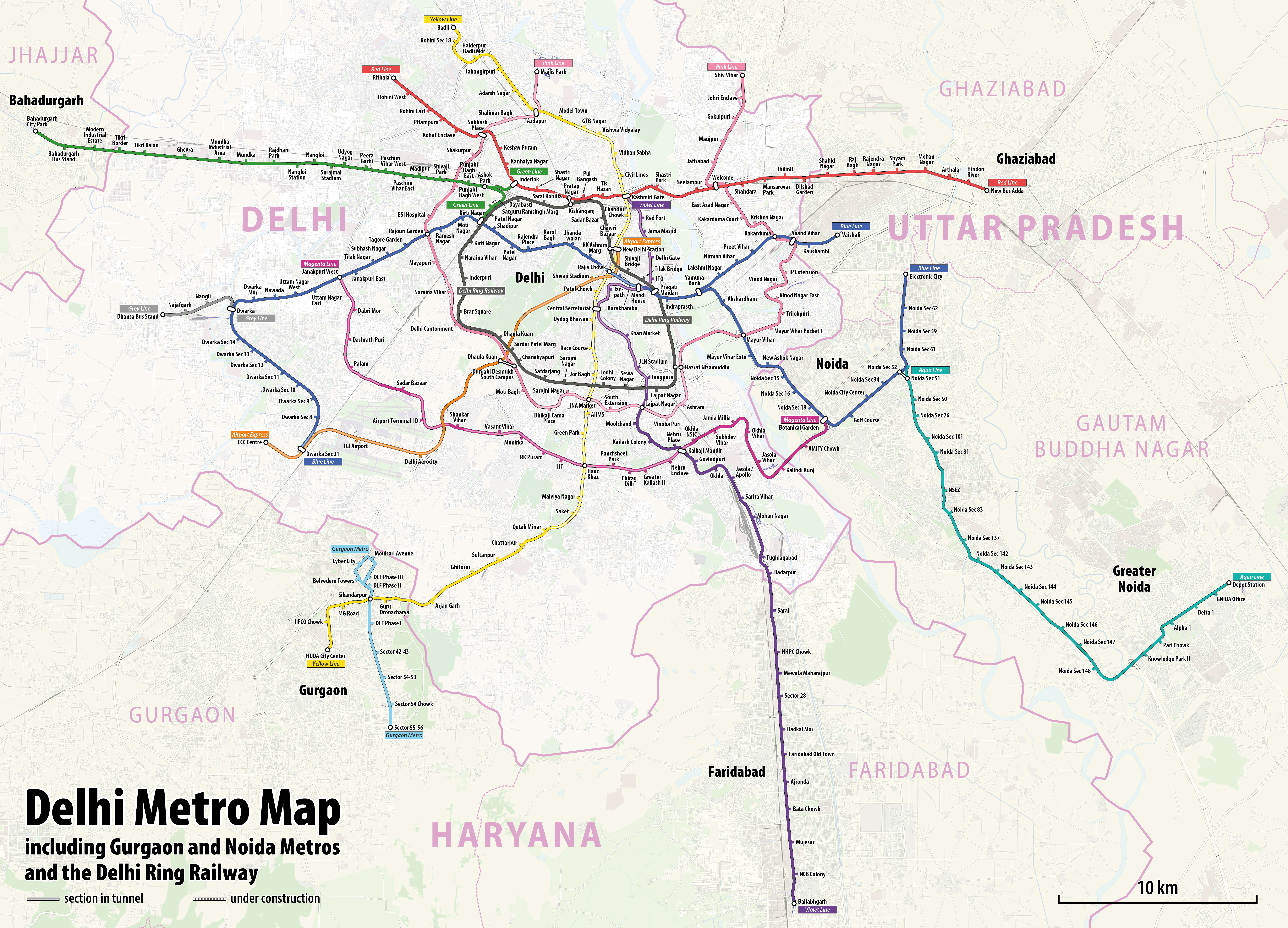
| 目前 | 2022年3月19日 (六) 12:42 | | 6,675 × 4,808(17.08 MB) | Painjet(留言 | 貢獻) | The section between Trilokpuri Sanjay Lake and Mayur Vihar Pocket I was opened on 6 August 2021. |
| 2020年1月19日 (日) 16:59 |  | 6,675 × 4,808(17.27 MB) | Chumwa(留言 | 貢獻) | == {{int:filedesc}} == {{Information |Description= *{{de|1=Linienplan der U-Bahnlinien und der Ringeisenbahn von Delhi}} *{{en|Map of the metro lines and the ring railway of Delhi}} |Author=Maximilian Dörrbecker (Chumwa) |Source={{own using}} OpenStreetMap data for the background |Date=see file history |Permission=All OpenStreetMap data and maps are Creative Commons "CC-BY-SA 2.0" licensed{{cc-by-sa-2.0}} |other_versions= }} [[Category:Public t... |
無法覆蓋此檔案。
檔案用途
下列6個頁面有用到此檔案:
- User:Chumwa/OgreBot/Potential transport maps/2020 January 11-20
- User:Chumwa/OgreBot/Public transport information/2020 January 11-20
- User:Chumwa/OgreBot/Public transport information/2022 March 11-20
- User:Chumwa/OgreBot/Transport Maps/2020 January 11-20
- User:Chumwa/OgreBot/Transport Maps/2022 March 11-20
- File:Delhi and sarroundings aerial photo 08-2016 img3.jpg
全域檔案使用狀況
以下其他 wiki 使用了這個檔案:
- azb.wikipedia.org 的使用狀況
- be.wikipedia.org 的使用狀況
- bn.wikipedia.org 的使用狀況
- ca.wikipedia.org 的使用狀況
- cs.wikipedia.org 的使用狀況
- de.wikipedia.org 的使用狀況
- de.wikivoyage.org 的使用狀況
- en.wikipedia.org 的使用狀況
- en.wikivoyage.org 的使用狀況
- es.wikipedia.org 的使用狀況
- fa.wikipedia.org 的使用狀況
- fi.wikipedia.org 的使用狀況
- fi.wikivoyage.org 的使用狀況
- fr.wikipedia.org 的使用狀況
- fr.wikivoyage.org 的使用狀況
- hi.wikipedia.org 的使用狀況
- hu.wikipedia.org 的使用狀況
- hy.wikipedia.org 的使用狀況
- id.wikipedia.org 的使用狀況
- incubator.wikimedia.org 的使用狀況
- it.wikipedia.org 的使用狀況
- ja.wikipedia.org 的使用狀況
- ka.wikipedia.org 的使用狀況
- ko.wikipedia.org 的使用狀況
- mai.wikipedia.org 的使用狀況
- ml.wikipedia.org 的使用狀況
- mr.wikipedia.org 的使用狀況
- nl.wikipedia.org 的使用狀況
- nl.wikivoyage.org 的使用狀況
檢視此檔案的更多全域使用狀況。