File:Raymond Oct 21 2013 2010Z.jpg
跳转到导航
跳转到搜索

本预览的尺寸:459 × 599像素。 其他分辨率:184 × 240像素 | 368 × 480像素 | 588 × 768像素 | 784 × 1,024像素 | 1,569 × 2,048像素 | 7,200 × 9,400像素。
原始文件 (7,200 × 9,400像素,文件大小:10.65 MB,MIME类型:image/jpeg)
说明
说明
添加一行文字以描述该文件所表现的内容
摘要[编辑]
| 描述 |
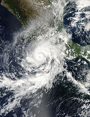
English: Hurricane Raymond was at its strongest when the Moderate Resolution Imaging Spectroradiometer (MODIS) on NASA’s Aqua satellite acquired this image at 3:10 p.m. on October 21, 2013. The Category 3 storm had sustained winds near 195 kilometers (120 miles) per hour as it spun off Mexico’s western shore.
Though Raymond was not forecast to come ashore, it poses a threat to flood-weary Acapulco and nearby communities. The storm’s outer bands are circulating over coastal regions, unleashing heavy rain. Since Raymond is stalled offshore, the rain has persisted since Saturday. From Saturday to Monday, Acapulco received 5.67 inches of rain, reported Jeff Masters. The same region flooded in September when Tropical Storm Manuel came ashore. Raymond is expected to move west away from Mexico on Wednesday, October 23. |
| 日期 | |
| 来源 | http://earthobservatory.nasa.gov/NaturalHazards/view.php?id=82224 |
| 作者 | NASA image courtesy Jeff Schmaltz, LANCE/EOSDIS MODIS Rapid Response Team at NASA GSFC. Caption by Holli Riebeek. |
| 其他版本 |
.jpg)
许可协议[编辑]
| 本文件完全由NASA创作,在美国属于公有领域。根据NASA的版权方针,NASA的材料除非另有声明否则不受版权保护。(参见Template:PD-USGov/zh、NASA版权方针页面或JPL图片使用方针。) | ||
 |
警告:
|
文件历史
点击某个日期/时间查看对应时刻的文件。
| 日期/时间 | 缩略图 | 大小 | 用户 | 备注 | |
|---|---|---|---|---|---|
| 当前 | 2013年10月22日 (二) 03:46 | | 7,200 × 9,400(10.65 MB) | TheAustinMan(留言 | 贡献) | Gallery version, not sure what the differences are but this is the official version from the guys at NASA |
| 2013年10月22日 (二) 00:07 |  | 7,100 × 8,500(11.92 MB) | Supportstorm(留言 | 贡献) | {{Information |Description ={{en|1=Hurricane Raymond on October 21, 2013}} |Source =http://lance-modis.eosdis.nasa.gov/wms/?zoom=4&lat=19.20118&lon=-88.86914&layers=000B0FFFFT&datum1=10/21/2013 |Author =NASA, MODIS/ LANCE |Date ... |
您不可以覆盖此文件。
文件用途
以下页面使用本文件:
全域文件用途
以下其他wiki使用此文件:
- de.wikipedia.org上的用途
- es.wikipedia.org上的用途
- fr.wikipedia.org上的用途
- ko.wikipedia.org上的用途
- zh.wikipedia.org上的用途