File:Red actual de ferrocarriles de España (ancho europeo).png
跳至導覽
跳至搜尋

預覽大小:776 × 600 像素。 其他解析度:311 × 240 像素 | 621 × 480 像素 | 994 × 768 像素 | 1,280 × 989 像素 | 2,560 × 1,979 像素 | 4,437 × 3,430 像素。
原始檔案 (4,437 × 3,430 像素,檔案大小:760 KB,MIME 類型:image/png)
說明
說明
添加單行說明來描述出檔案所代表的內容
摘要
[編輯].png&action=edit§ion=1)
| 描述 |
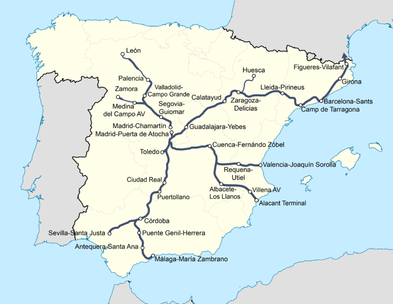
Español: Red actual de ferrocarriles de España de ancho europeo. No se corresponde exactamente con las líneas de alta velocidad (ver File:Spain High Speed Rail.svg) debido a la elección temporal de ancho ibérico para la línea de alta velocidad de Galicia.
English: Current Stephenson gauge (1.435 mm) rail network in Spain. I differs from the high speed network (see File:Spain High Speed Rail.svg) due to the temporal choice of iberian gauge for the Galician HSL. |
| 日期 | (updated june 2017) |
| 來源 | 自己的作品 |
| 作者 | Alejandro Navarro López (Usuario: Manchego) |
| 授權許可 (重用此檔案) |
GFDL |
| 其他版本 |
    .png) |
授權條款
[編輯].png&action=edit§ion=2)

|
已授權您依據自由軟體基金會發行的無固定段落、封面文字和封底文字GNU自由文件授權條款1.2版或任意後續版本,對本檔進行複製、傳播和/或修改。該協議的副本列在GNU自由文件授權條款中。 |
| 此檔案採用共享創意 姓名標示-相同方式分享 3.0 未在地化版本授權條款。 | ||
| ||
| 已新增授權條款標題至此檔案,作為GFDL授權更新的一部份。 |
檔案歷史
點選日期/時間以檢視該時間的檔案版本。
| 日期/時間 | 縮圖 | 尺寸 | 用戶 | 備註 | |
|---|---|---|---|---|---|
| 目前 | 2017年6月24日 (六) 15:01 | | 4,437 × 3,430(760 KB) | LAVF(對話 | 貢獻) | Se amplia a Zamora y León. |
| 2013年7月8日 (一) 14:11 |  | 4,437 × 3,430(1,014 KB) | Val de Ornia(對話 | 貢獻) | Incluye Albacete-Alicante. | |
| 2013年2月10日 (日) 16:53 |  | 4,437 × 3,430(782 KB) | HrAd(對話 | 貢獻) | Orthography | |
| 2013年1月3日 (四) 11:22 |  | 2,131 × 1,647(329 KB) | HrAd(對話 | 貢獻) | Updated to January 2013 | |
| 2011年9月8日 (四) 12:24 |  | 1,400 × 1,126(464 KB) | HrAd(對話 | 貢獻) | New base map, more geographical drawing, simpler. | |
| 2011年1月10日 (一) 22:21 |  | 3,800 × 3,053(2.13 MB) | Manchego(對話 | 貢獻) | Version 3.0 Añado las vías de ancho internacional a Cuenca, Albacete y Valencia. | |
| 2009年11月29日 (日) 23:02 |  | 3,110 × 2,496(1.17 MB) | Manchego(對話 | 貢獻) | - Añadidas próximas inauguraciones - Añadida leyenda - Retoques cosméticos | |
| 2008年2月16日 (六) 16:51 |  | 3,105 × 2,492(1.03 MB) | Manchego(對話 | 貢獻) | {{Information |Description=Red actual de ferrocarriles de España de ancho europeo. Versión 1.1. |Source=Trabajo propio |Date=16-02-2008 |Author=Alejandro Navarro López (Usuario: Manchego) |Permission=GFDL |other_versions= [[Image:Prov | |
| 2008年1月12日 (六) 17:47 |  | 3,105 × 2,492(1.02 MB) | Manchego(對話 | 貢獻) | == Sumario == {{Information |Description=Red actual de ferrocarriles de España de ancho europeo. Versión 1.0. |Source=Trabajo propio |Date=07-01-2008 |Author=Alejandro Navarro López (Usuario: Manchego) |Permission=GFDL |other_versions |
無法覆蓋此檔案。
檔案用途
下列7個頁面有用到此檔案:
- User:Chumwa/OgreBot/Potential transport maps/2017 June 21-30
- User:Chumwa/OgreBot/Public transport information/2017 June 21-30
- User:Chumwa/OgreBot/Transport Maps/2017 June 21-30
- User:Chumwa/OgreBot/Travel and communication maps/2017 June 21-30
- File:Red actual de ferrocarriles de España.png
- File:Red actual de ferrocarriles de España.svg
- File:Red actual de ferrocarriles de España (ancho ibérico).png
.png&oldid=477127784)