File:Regenbogen location map.svg
Ir a la navegación
Ir a la búsqueda

Tamaño de esta previsualización PNG del archivo SVG: 424 × 600 píxeles. Otras resoluciones: 170 × 240 píxeles | 339 × 480 píxeles | 543 × 768 píxeles | 724 × 1024 píxeles | 1448 × 2048 píxeles | 744 × 1052 píxeles.
Archivo original (archivo SVG, nominalmente 744 × 1052 píxeles, tamaño de archivo: 1,92 MB)
Leyendas
Leyendas
Añade una explicación corta acerca de lo que representa este archivo
| Descripción |
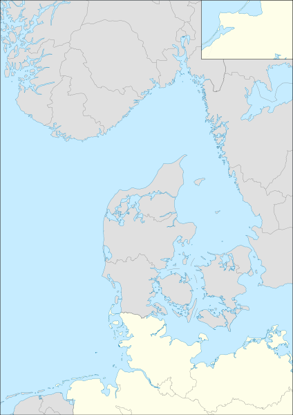
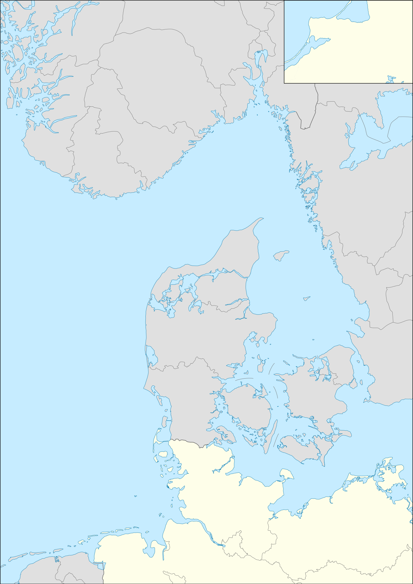
English: Location map for Operation Regenbogen Equirectangular projection. Geographic limits of the map:
|
| Fecha | (UTC) |
| Fuente | |
| Autor | |
| SVG desarrollo | El código fuente de esta imagen SVG es válido. Este mapa fue creado con Inkscape, o con otro programa. |
Este archivo se encuentra bajo la licencia Creative Commons Genérica de Atribución/Compartir-Igual 3.0.
- Eres libre:
- de compartir – de copiar, distribuir y transmitir el trabajo
- de remezclar – de adaptar el trabajo
- Bajo las siguientes condiciones:
- atribución – Debes otorgar el crédito correspondiente, proporcionar un enlace a la licencia e indicar si realizaste algún cambio. Puedes hacerlo de cualquier manera razonable pero no de manera que sugiera que el licenciante te respalda a ti o al uso que hagas del trabajo.
- compartir igual – En caso de mezclar, transformar o modificar este trabajo, deberás distribuir el trabajo resultante bajo la misma licencia o una compatible como el original.
Registro original de carga
[editar]
This image is a derivative work of the following images:
- File:Germany location map.svg licensed with Cc-by-sa-3.0, GFDL
- 2010-01-19T10:03:29Z NordNordWest 1073x1272 (502104 Bytes) update
- 2009-07-22T08:33:33Z NordNordWest 1075x1273 (623082 Bytes) c
- 2008-10-13T14:36:44Z NordNordWest 1075x1273 (620685 Bytes)
- 2008-10-09T21:13:47Z NordNordWest 1075x1273 (627868 Bytes) smaller file, data optimized
- 2008-06-30T20:25:05Z NordNordWest] 1076x1274 (899543 Bytes) {{Information |Description= {{de|Positionskarte von [[:de:Deutschland|Deutschland]]}} Quadratische Plattkarte, N-S-Streckung 150 %. Geographische Begrenzung der Karte: * N: 55.1° N * S: 47.2° N * W: 5.5° O * O: 15.5° O {{
- File:Denmark location map.svg licensed with Cc-by-sa-3.0, GFDL
- 2008-08-25T18:57:20Z NordNordWest 1836x1479 (451991 Bytes) size correction
- 2008-07-02T08:53:40Z NordNordWest 612x493 (444624 Bytes) {{Information |Description= {{de|Positionskarte von [[:de:Dänemark|Dänemark]]}} Quadratische Plattkarte, N-S-Streckung 170 %. Geographische Begrenzung der Karte: * N: 57.9° N * S: 54.3° N * W: 8.8° O * O: 15.4° O {{en|L
- File:Norway location map.svg licensed with Cc-by-sa-3.0, GFDL
- 2008-10-25T20:26:43Z NordNordWest 2215x2353 (2224863 Bytes) corrected
- 2008-08-29T07:56:18Z NordNordWest 2215x2351 (2226297 Bytes)
- 2008-07-28T20:12:55Z NordNordWest 2214x2351 (1894995 Bytes) some corrections
- 2008-07-28T19:47:02Z NordNordWest 2214x2351 (1894765 Bytes) {{Information |Description= {{de|Positionskarte der [[:de:Norwegen|Norwegen]]}} Quadratische Plattkarte, N-S-Streckung 210 %. Geographische Begrenzung der Karte: * N: 71.5° N * S: 57.6° N * W: 4.1° O * O: 31.6° O {{en|Loc
- File:Sweden location map.svg licensed with Cc-by-sa-3.0, GFDL
- 2009-01-27T09:24:12Z Erik Frohne 954x1837 (2870529 Bytes) Added missing border Scania-Blekinge [[Category:Location maps of Sweden]]
- 2008-08-29T08:22:02Z NordNordWest 954x1837 (2868511 Bytes)
- 2008-08-29T08:18:13Z NordNordWest 954x1837 (1529461 Bytes)
- 2008-07-30T11:32:56Z NordNordWest 954x1836 (1527204 Bytes) optimized
- 2008-07-15T18:28:06Z NordNordWest 954x1836 (2123748 Bytes) {{Information |Description= {{de|Positionskarte von [[:de:Schweden|Schweden]]}} Quadratische Plattkarte, N-S-Streckung 190 %. Geographische Begrenzung der Karte: * N: 69.5° N * S: 55.1° N * W: 10.4° O * O: 24.6° O {{en|Lo
- File:Netherlands location map.svg licensed with Cc-by-sa-3.0, GFDL
- 2008-09-11T16:26:25Z Lencer 888x1001 (235175 Bytes) {{Information |Description= |Source= |Date= |Author= |Permission= |other_versions= }}
- 2008-09-10T15:15:26Z Lencer 888x1001 (235195 Bytes) {{Information |Description= |Source= |Date= |Author= |Permission= |other_versions= }}
- 2008-09-09T18:35:56Z Lencer 888x1001 (234406 Bytes) {{Information |Description= |Source= |Date= |Author= |Permission= |other_versions= }}
- 2008-08-16T12:15:18Z Lencer 888x1001 (234098 Bytes) {{Information |Description= |Source= |Date= |Author= |Permission= |other_versions= }}
- 2008-07-24T11:14:56Z NordNordWest 354x399 (218910 Bytes)
- 2008-07-24T11:10:58Z NordNordWest 354x399 (210601 Bytes)
- 2008-07-24T11:03:52Z NordNordWest 354x399 (219496 Bytes)
- 2008-07-24T10:57:42Z NordNordWest 354x399 (129554 Bytes) {{Information |Description= {{de|Positionskarte der [[:de:Niederlande|Niederlande]]}} Quadratische Plattkarte, N-S-Streckung 160 %. Geographische Begrenzung der Karte: * N: 53.7° N * S: 50.6° N * W: 3.1° O * O: 7.5�
Uploaded with derivativeFX
Historial del archivo
Haz clic sobre una fecha y hora para ver el archivo tal como apareció en ese momento.
| Fecha y hora | Miniatura | Dimensiones | Usuario | Comentario | |
|---|---|---|---|---|---|
| actual | 13:29 9 may 2010 | | 744 × 1052 (1,92 MB) | Mike1979 Russia (discusión | contribs.) | redraw |
| 09:53 26 abr 2010 |  | 744 × 1052 (2,11 MB) | Mike1979 Russia (discusión | contribs.) | {{Information |Description={{en|Location map for Operation Regenbogen}} Equirectangular projection. Geographic limits of the map: * N: 61.64° N * S: 52.17° N * W: 4.1° E * E: 15.5° E |Source=*[[:File:Germany_loca |
No puedes sobrescribir este archivo.
Usos del archivo
No hay páginas que enlacen a este archivo.
Uso global del archivo
Las wikis siguientes utilizan este archivo:
- Uso en ba.wikipedia.org
- Uso en de.wikipedia.org
- Uso en ru.wikipedia.org