File:ReichskommissariatUkraineMap.png
跳至導覽
跳至搜尋
預覽大小:765 × 600 像素。 其他解析度:306 × 240 像素 | 612 × 480 像素 | 980 × 768 像素 | 1,280 × 1,004 像素 | 2,560 × 2,007 像素 | 3,000 × 2,352 像素。
原始檔案 (3,000 × 2,352 像素,檔案大小:1.36 MB,MIME 類型:image/png)
說明
說明
添加單行說明來描述出檔案所代表的內容
摘要
[編輯]
| 描述 |
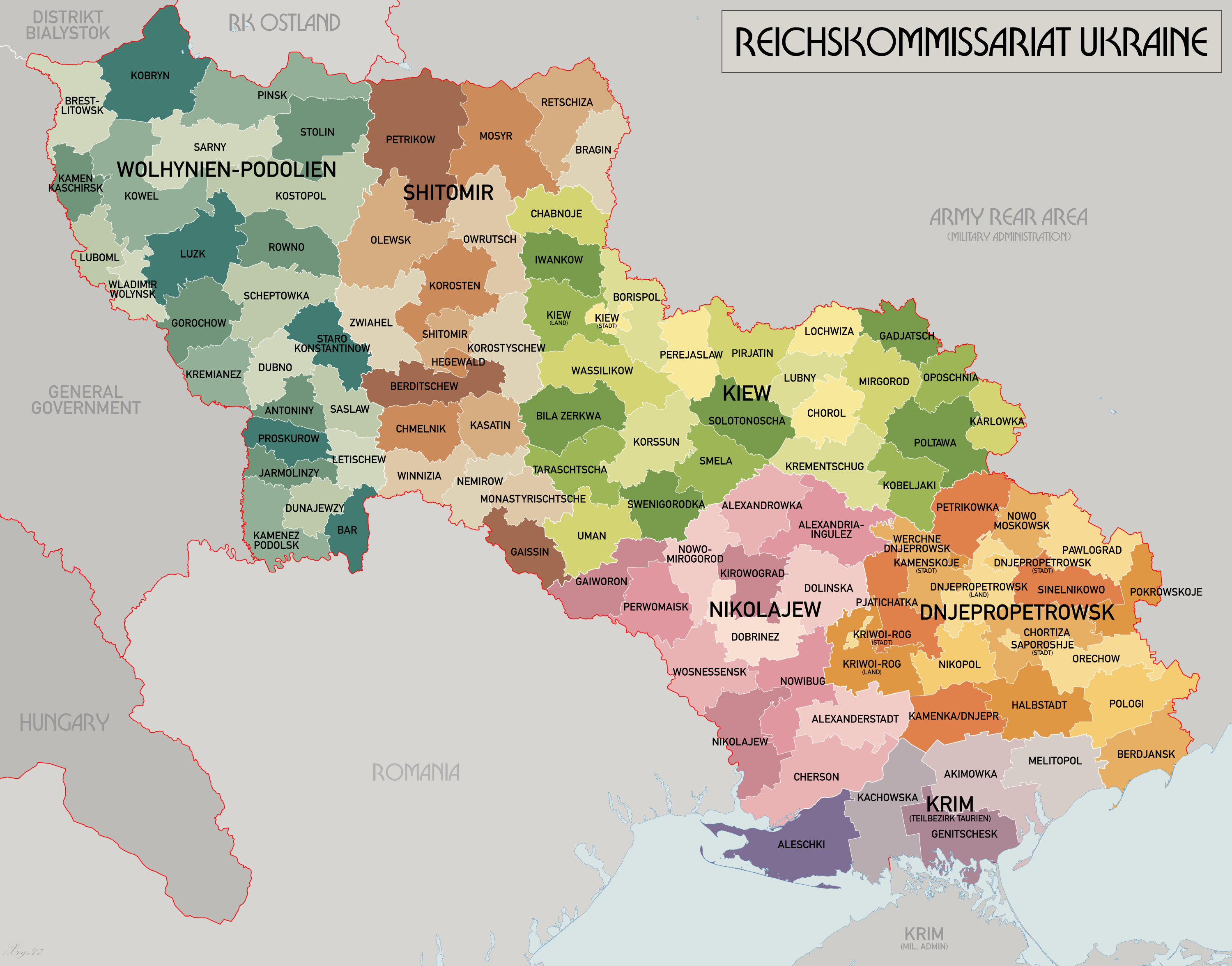
English: An administrative map of the Reichskommissariat Ukraine. Shows the boundaries of the Generalbezirke and Kreisgebiete as of September 1943. Source map data:
|
| 日期 | |
| 來源 | 自己的作品 |
| 作者 | XrysD |
| 其他版本 | 此檔案衍生的作品: HegewaldColonyMap.png |
授權條款
[編輯]
我,本作品的著作權持有者,決定用以下授權條款發佈本作品:

|
已授權您依據自由軟體基金會發行的無固定段落、封面文字和封底文字GNU自由文件授權條款1.2版或任意後續版本,對本檔進行複製、傳播和/或修改。該協議的副本列在GNU自由文件授權條款中。 |
| 此檔案採用創用CC 姓名標示-相同方式分享 3.0 未在地化版本授權條款。 | ||
| ||
| 已新增授權條款標題至此檔案,作為GFDL授權更新的一部份。 |
檔案歷史
點選日期/時間以檢視該時間的檔案版本。
| 日期/時間 | 縮圖 | 尺寸 | 使用者 | 備註 | |
|---|---|---|---|---|---|
| 目前 | 2017年5月21日 (日) 09:25 | | 3,000 × 2,352(1.36 MB) | XrysD(留言 | 貢獻) | Reduced size and fixed edge issue. |
| 2017年5月21日 (日) 09:21 |  | 4,000 × 3,197(1.95 MB) | XrysD(留言 | 貢獻) | Completely new version. Source map data: [Verwaltungskarten Gebietes Ukraine 1:500k, US Library of Congress], [Karte des Deutschen Reiches (Grossblatter) 1:100k, Mapa Administracyjna Rzeczypospolitej Polska 1:300k, Karte von Mitteleuropa 1:300k, MapyWig] | |
| 2015年12月8日 (二) 16:39 |  | 1,803 × 1,060(714 KB) | Artemco(留言 | 貢獻) | • occupied territory under military administration, not directly Soviet Union • capital letters as Romania had • C → G | |
| 2012年5月16日 (三) 20:59 |  | 1,803 × 1,060(708 KB) | XrysD(留言 | 貢獻) | Added legend. Changed surrounding state names to common English versions. Changed colour set to Bartholomew version. | |
| 2008年7月22日 (二) 13:01 |  | 1,803 × 1,060(205 KB) | XrysD(留言 | 貢獻) | {{Information |Description={{en|1=An administrative map of the Reichskommissariat Ukraine. Shows the boundaries of the Generalbezirke and Kreisgebiete as of September 1943.}} |Source=Own work by uploader |Author=XrysD |Date=2008 |Permission |
無法覆蓋此檔案。
檔案用途
下列6個頁面有用到此檔案:
.png)
全域檔案使用狀況
以下其他 wiki 使用了這個檔案:
- ar.wikipedia.org 的使用狀況
- az.wikipedia.org 的使用狀況
- be-tarask.wikipedia.org 的使用狀況
- be.wikipedia.org 的使用狀況
- bs.wikipedia.org 的使用狀況
- ca.wikipedia.org 的使用狀況
- cs.wikipedia.org 的使用狀況
- da.wikipedia.org 的使用狀況
- en.wikipedia.org 的使用狀況
- es.wikipedia.org 的使用狀況
- fa.wikipedia.org 的使用狀況
- fr.wikipedia.org 的使用狀況
- he.wikipedia.org 的使用狀況
- hr.wikipedia.org 的使用狀況
- id.wikipedia.org 的使用狀況
- it.wikipedia.org 的使用狀況
- ja.wikipedia.org 的使用狀況
- lt.wikipedia.org 的使用狀況
- ms.wikipedia.org 的使用狀況
- nl.wikipedia.org 的使用狀況
- pl.wikipedia.org 的使用狀況
- pt.wikipedia.org 的使用狀況
- ro.wikipedia.org 的使用狀況
- ru.wikipedia.org 的使用狀況
- sh.wikipedia.org 的使用狀況
- sr.wikipedia.org 的使用狀況
- sv.wikipedia.org 的使用狀況
- th.wikipedia.org 的使用狀況
- uk.wikipedia.org 的使用狀況
檢視此檔案的更多全域使用狀況。