File:Reull Vallis lineated deposits.jpg
跳转到导航
跳转到搜索
没有更高的分辨率。
Reull_Vallis_lineated_deposits.jpg (620 × 460像素,文件大小:51 KB,MIME类型:image/jpeg)
说明
说明
添加一行文字以描述该文件所表现的内容
摘要
[编辑]
| 描述 |
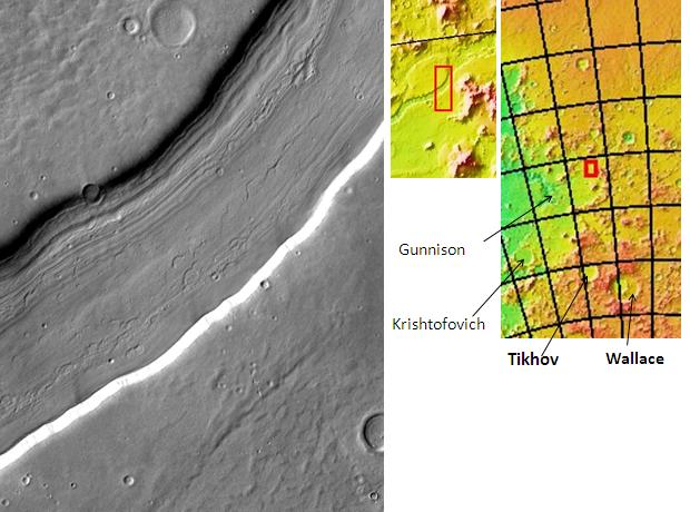
English: Reull Vallis lineated deposits, as seen by themis. Picture is located 41.1 degrees south latitude and 107.6 degrees east longitude. Picture is about 17 km wide. اردو : رول ویلس دھاری دار فرشی ذخیروں کے ساتھ۔ محل وقوع ہیلس چو گوشہ ہے۔ |
| 日期 | |
| 来源 | http:themis.asu.edu/zoom-20021055a |
| 作者 | Jim Secosky modified NASA image |
许可协议
[编辑]
| 本文件完全由NASA创作,在美国属于公有领域。根据NASA的版权方针,NASA的材料除非另有声明否则不受版权保护。(参见Template:PD-USGov/zh、NASA版权方针页面或JPL图片使用方针。) | ||
 |
警告:
|
原始上传日志
[编辑]
The original description page was here. All following user names refer to en.wikipedia.
- 2009-02-23 16:09 Jimmarsmars 620×460× (52541 bytes) {{Information |Description=Reull Vallis lineated deposits, as seen by themis. Picture is located 41.1 degrees south latitude and 107.6 degrees east longitude. Picture is about 17 km wide. |Source=http:themis.asu.edu/zoom-20021055a |Date=February 23, 200

|
本图像的分类需要调整。 马上检查!
|
文件历史
点击某个日期/时间查看对应时刻的文件。
| 日期/时间 | 缩略图 | 大小 | 用户 | 备注 | |
|---|---|---|---|---|---|
| 当前 | 2015年10月19日 (一) 08:16 | | 620 × 460(51 KB) | زہیر عبّاس(留言 | 贡献) | User created page with UploadWizard |
您不可以覆盖此文件。
文件用途
没有页面使用本文件。
全域文件用途
以下其他wiki使用此文件:
- ca.wikipedia.org上的用途
- en.wikipedia.org上的用途
- Vallis (planetary geology)
- Thermal Emission Imaging System
- Reull Vallis
- Hellas quadrangle
- Water on Mars
- Lobate debris apron
- Fretted terrain
- Lineated valley fill
- Chronology of discoveries of water on Mars
- Evidence of water on Mars from Mars Odyssey
- Common surface features of Mars
- User:Yildiztozu/sandbox
- es.wikipedia.org上的用途
- pnb.wikipedia.org上的用途
- ur.wikipedia.org上的用途
- zh.wikipedia.org上的用途