File:Rif Aleppo2.svg

Archivo original (archivo SVG, nominalmente 1293 × 655 píxeles, tamaño de archivo: 7,13 MB)
Leyendas
Leyendas

Resumen[editar]
| Descripción |
Bahasa Indonesia: Dikuasai oleh Angkatan Bersenjata Suriah
Dikuasai oleh Angkatan Kurdi
Wilayah dipertentangkan
Dikuasai oleh Angkatan Oposisi Bosanski: Pod kontrolom Vladinih snaga
Pod kontrolom Kurda
Linija između suprotstavljenih snaga Català: Controlat pel govern
Controlat pels kurds
Controlat per forces rebels
Controlat per Front Al-Nusra
Zones disputades Čeština: Pod kontrolou syrské vlády
Pod kontrolou syrské opozice
Pod kontrolou syrských Kurdů
Pod kontrolou Fronty an-Nusrá
Sporná hranice mezi válčícími stranami Dansk: Kontrolleret af pro-Assad-styrker
Kontrolleret af syriske kurdere
Omstridt område
Kontrolleret af den Syriske Nationale Koalition (den syriske opposition)
Kontrolleret af Al-Nusra-Fronten Deutsch: Von pro-Assad Kräften kontrolliert
Von kurdischen Kräften kontrolliert
Umkämpftes Gebiet
Von Oppositionskräften kontrolliert
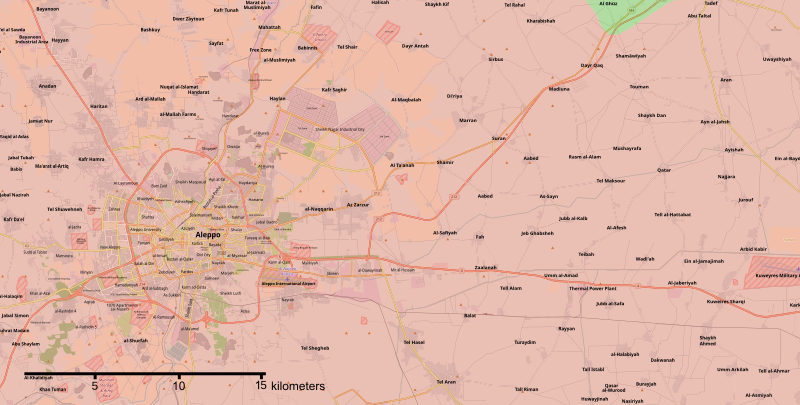
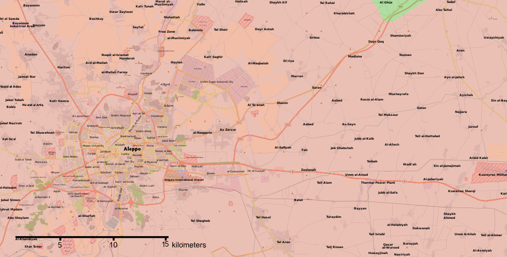
Von Al-Nusra-Front kontrolliert English: Map of the current situation in Aleppo, during the Battle of Aleppo (2012–present). After updating this map, please also update the date(s) at w:Module:Iraq Syria map date, used to denote the date in articles.
Controlled by the Syrian Armed Forces
Controlled by the People's Protection Units (Kurdish Forces)
Controlled by the Opposition Forces
Controlled by the al-Nusra Front
The disputed frontline between the forces Español: Zonas controladas por fuerzas pro-Assad
Zonas controladas por fuerzas kurdas
Zonas en disputa
Zonas controladas por fuerzas anti-Assad Français : Zones sous contrôle pro-Assad
Zones sous contrôle kurde
Zones disputées
Zones sous contrôle anti-Assad Hrvatski: Pod kontrolom Assadovih snaga
Pod kontolom Kurda
Linija između suprostravljenih snaga
Pod kontrolom protu-vladinih snaga Italiano: Zone sotto il controllo di forze Pro-Assad
Zone sotto controllo curdo
Fronte militare tra le forze
Zone sotto controllo dei ribelli Magyar: A szíriai hadsereg ellenőrzése alatt
A szíriai kurdok ellenőrzése alatt
A szíriai ellenzéki erők koalíciójának ellenőrzése alatt
Az Al-Nuszra Front ellenőrzése alatt
Vitatott ellenőrzésű terület Nederlands: In handen van de Syrische overheid
In handen van Koerdische troepen (Rojava)
Betwist gebied
Gecontroleerd door anti-Assad strijders Polski: Tereny kontrolowane przez Siły Zbrojne Syrii
Tereny kontrolowane przez Powszechne Jednostki Ochrony (siły Kurdów)
Tereny kontrolowane przez Syryjską Koalicję Narodową na rzecz Opozycji i Sił Rewolucyjnych
Tereny sporne Português: Zonas controladas por forças pro-Assad
Zonas controladas por forças kurdas
Zonas em disputa
Zonas controladas por outras forças anti-Assad Română: Zone controlate de forțele pro-Assad
Zone controlate de forțele kurde
Zone disputate
Zone controlate de forțele anti-Assad Shqip: E kontrolluar nga forcat e Assadit
E kontrolluar nga forcat Kurde
E kontrolluar nga rebelet anti-Assad Slovenščina: Pod nadzorom sirijske vlade
Pod nadzorom sirijske opozicije
Pod nadzorom sirijskih Kurdov
Pod nadzorom al-Nusre
Sporno območje med več stranmi Tiếng Việt: Kiểm soát bởi lực lượng thân Assad
Kiểm soát bởi lực lượng người Kurd
Kiểm soát bởi lực lượng chống Assad Türkçe: Esad güçlerinin kontrolünde
Kürt güçlerin kontrolünde
İhtilaflı bölge
Esad karşıtı güçlerin kontrolünde Български: Под контрол на правителствените сили
Под контрол на кюрдските милиции
Оспорвани земи
Под контрол на бунтовниците Қазақша: Асадтың билік бақылауында
Күрд күштердің бақылауында
даулы аумағы
Қарсы Асад күштерінің бақылауында
Русский: Контролируются правительственными силами
Контролируются курдскими силами
Спорная территория между воюющими сторонами
Контролируются антиправительственной коалицией Српски (ћирилица): Под контролом Асадових снага
Под контролом Курда
Линија између супрострављених снага
Под контролом побуњеничких снага Українська: Контролюється владою Сирії
Контролюється курдами
Спірні території
Території, що підконтрольні опозиції Հայերեն : Կառավարվում է Սիրիական կառավարական ուժերի կողմից
Կառավարվում է քրդերի կողմից
Կառավարվում է ընդդիմադիր ուժերի կողմից
Կառավարվում է "ան-Նուսրա" խմբավորման կողմից
Հակամարտող կոմղերի միջև վիճելի տարածքներ संस्कृतम् : असदसमर्थक सेनानाम् नियन्त्रणे क्षेत्राः
कुर्द सेनानाम् नियन्त्रणे क्षेत्राः
सेनानाम् मध्ये विवदित क्षेत्राः
असदविरोधी सेनानाम् नियन्त्रणे क्षेत्राः 한국어: 정부군 점령 지역
쿠르드족 점령 지역
양 세력 간 전선 지역
반정부군 점령 지역 中文: 巴沙尔·阿萨德政权控制的区域
库尔德人控制的区域
争夺中的区域
其他反巴沙尔政权的武装控制的区域 עברית : בשליטת כוחות נאמני אסד
בשליטת כוחות כורדים
איזור במחלוקת בין הכוחות
בשליטת כוחות מתנגדי אסד العربية : القوات الحكومية
القوات الكردية
مناطق مواجهات غير محسومة
قوات المعارضة كوردي (عەرەبی): سوپای ڕژێم
هێزه كوردیهكان
ئهو ناوچانهی چارهنوسیان یهكلا نهبۆتهوه
هێزهكانی ئۆپۆزسیۆن |
||
| Fecha | |||
| Fuente | Trabajo propio | ||
| Autor | Kami888 | ||
| Otras versiones |
|


.svg)


.svg)
.png)


Licencia[editar]
| This work contains information from OpenStreetMap, which is made available under the Open Database License (ODbL).
The ODbL does not require any particular license for maps produced from ODbL data. Prior to 1 August 2020, map tiles produced by the OpenStreetMap Foundation were licensed under the CC-BY-SA-2.0 license. Maps produced by other people may be subject to other licences. |
- Eres libre:
- de compartir – de copiar, distribuir y transmitir el trabajo
- de remezclar – de adaptar el trabajo
- Bajo las siguientes condiciones:
- atribución – Debes otorgar el crédito correspondiente, proporcionar un enlace a la licencia e indicar si realizaste algún cambio. Puedes hacerlo de cualquier manera razonable pero no de manera que sugiera que el licenciante te respalda a ti o al uso que hagas del trabajo.
- compartir igual – En caso de mezclar, transformar o modificar este trabajo, deberás distribuir el trabajo resultante bajo la misma licencia o una compatible como el original.
Historial del archivo
Haz clic sobre una fecha y hora para ver el archivo tal como apareció en ese momento.
| Fecha y hora | Miniatura | Dimensiones | Usuario | Comentario | |
|---|---|---|---|---|---|
| actual | 01:31 17 feb 2020 | | 1293 × 655 (7,13 MB) | Kami888 (discusión | contribs.) | final update. this map is no longer useful. |
| 22:39 16 feb 2020 |  | 1293 × 655 (7,2 MB) | Kami888 (discusión | contribs.) | updates | |
| 23:26 15 feb 2020 |  | 1293 × 655 (7,2 MB) | Kami888 (discusión | contribs.) | updates | |
| 22:59 11 feb 2020 |  | 1293 × 655 (7,23 MB) | Kami888 (discusión | contribs.) | updates and more labels | |
| 00:49 31 ene 2020 |  | 1293 × 655 (7,24 MB) | Kami888 (discusión | contribs.) | updates | |
| 20:11 5 ene 2019 |  | 1293 × 655 (7,23 MB) | Kami888 (discusión | contribs.) | white will also work on this map because it's the color of Nusra/HTS which seems to be the dominant group in western aleppo at this point. | |
| 20:06 5 ene 2019 |  | 1293 × 655 (7,24 MB) | Kami888 (discusión | contribs.) | Due to the situation in western Aleppo, i'm changing the rebel color to white. White will work on the template map because it's the "neutral color" where you can still put green or gray towns and bases as necessary. | |
| 04:09 26 feb 2018 |  | 1293 × 655 (7,32 MB) | Kami888 (discusión | contribs.) | Matching with module/template: Fafin handed over to SAA. | |
| 16:59 24 feb 2018 |  | 1293 × 655 (7,32 MB) | Mehmedsons (discusión | contribs.) | Aleppo under the control of the Syrian army hawarnews.com/بيان-من-قيادة-وحدات-حماية-الشعب-في-حلب/ https://anfenglishmobile.com/news/ypg-statement-on-aleppo-25083 | |
| 16:53 24 feb 2018 |  | 1293 × 655 (7,34 MB) | Mehmedsons (discusión | contribs.) |
No puedes sobrescribir este archivo.
Usos del archivo
Hay más de 100 páginas que usan este archivo. La lista siguiente sólo muestra las primeras 100 páginas que usan este archivo. También puedes consultar la lista completa.
- User:Hermes79
- User:Hermes7979
- User:Magog the Ogre/Maps of conflicts/2016 August
- User:Magog the Ogre/Maps of conflicts/2016 December
- User:Magog the Ogre/Maps of conflicts/2016 July
- User:Magog the Ogre/Maps of conflicts/2016 May
- User:Magog the Ogre/Maps of conflicts/2016 November
- User:Magog the Ogre/Maps of conflicts/2016 October
- User:Magog the Ogre/Maps of conflicts/2016 September
- User:Magog the Ogre/Maps of conflicts/2017 February
- User:Magog the Ogre/Maps of conflicts/2017 January
- User:Magog the Ogre/Maps of conflicts/2017 March
- User:Magog the Ogre/Maps of conflicts/2018 February
- File:2013 Hama Offensive.svg
- File:2015 Latakia Frontlines.svg
- File:2016 Aleppo campaign (within Northern Syria).svg
- File:Aleppo Offensives 2015.svg
- File:Aleppo offensive (October 2013).svg
- File:Attaques-terroristes-meurtrières-au-21eme-siecle.png
- File:Battle of Daraa City.svg
- File:Battle of Hasakah.svg
- File:Battle of Qamishli.svg
- File:Battle of Raqqa.svg
- File:Battle of Tadmur.svg
- File:Battle of Western Qalamoun.svg
- File:Battlefields in The Global War on Terror.svg
- File:Battlefields in The Global War on Terror - edit03.png
- File:Battlefields in The Global War on Terror - edit04.png
- File:Benghazi Conflict Detailed Map.png
- File:Benghazi Conflict Detailed Map.svg
- File:Boko Haram insurgency map.svg
- File:Countries by soldier count.svg
- File:Daraa 2018 gif.gif
- File:Deir ez-Zor clashes (2017).svg
- File:Derna Conflict Detailed Map.png
- File:East Congo conflict map.svg
- File:GSPC map.png
- File:ISIS (Grey) Territory Change 2014-2016.gif
- File:Iraqi Civil War map (2014–present).png
- File:Iraqi–Kurdish conflict map.png
- File:Islamist insurgency in Nigeria.svg
- File:Lebanese insurgency.svg
- File:Libyan Civil War.svg
- File:Libyan war final-fr.svg
- File:Map of Ongoing conflicts around the world.png
- File:Map of terror of the Islamic State (ad-Daula al-islāmiyya).png
- File:Mexico states map small war.PNG
- File:Mosul offensive (2015) map.png
- File:Number of Terrorist Incidents.png
- File:Ongoing Conflicts (1).png
- File:Pakistan-Waziristan-Map.png
- File:Political map Afar triangle.png
- File:Rif Aleppo2.svg
- File:Rif Damashq.svg
- File:Siege of Homs Map.svg
- File:Sinai insurgency.svg
- File:Somali Civil War (2009-present).svg
- File:Syria and Iraq 2014-onward War map.png
- File:Syrian, Iraqi, and Lebanese insurgencies.png
- File:Syrian Civil War map.svg
- File:Syrian civil war.png
- File:Tadmur offensive (2015).jpg
- File:Turkish attack on Efrin.svg
- File:Yemeni Civil War.svg
- Template:City maps of ongoing civil wars
- Template:Maps of the civil war in Aleppo
- Category:Aleppo
- Category:Attack
- Category:Battle of Aleppo
- Category:Battles in 2016
- Category:Battles of Syria
- Category:Battles of the Syrian Civil War
- Category:Cities in Syria
- Category:Civil wars
- Category:Conflicts
- Category:Conflicts by continent
- Category:Conflicts by country
- Category:Conflicts by type
- Category:Feuds
- Category:Fights
- Category:Liberation of Palmyra (2016)
- Category:Maps of Aleppo
- Category:Maps of Somali Civil War
- Category:Maps of conflicts
- Category:Maps of disputed territories
- Category:Maps of the Syrian Civil War in 2016
- Category:Maps of the Syrian Civil War in 2017
- Category:Maps of the Syrian Civil War in 2018
- Category:Military conflicts
- Category:Ongoing armed conflicts
- Category:Palmyra offensive (December 2016)
- Category:Quarrels
- Category:Rebellions
- Category:Riots
- Category:Schisms
- Category:Syrian Civil War
- Category:Terrorism
- Category:Uprisings
- Category:War casualties
- Category:Warfare by type
.svg)
.svg)
_Territory_Change_2014-2016.gif)
.png)
.png)
_map.png)
.png)
.svg)
.jpg)
Mira más enlaces a este archivo.
Uso global del archivo
Las wikis siguientes utilizan este archivo:
- Uso en ar.wikipedia.org
- Uso en azb.wikipedia.org
- Uso en be.wikipedia.org
- Uso en cs.wikipedia.org
- Uso en de.wikipedia.org
- Uso en en.wikipedia.org
- User:SirVivor
- User:Lothar von Richthofen/Cities and towns
- Template:Syrian and Iraqi insurgency detailed map
- Module:Syrian and Iraqi insurgency detailed map/doc
- Template:Syrian, Iraqi, and Lebanese insurgencies detailed map
- Talk:Battle of Aden (2015)
- Module:Syrian, Iraqi, and Lebanese insurgencies detailed map/doc
- Wikipedia:Top 25 Report/December 11 to 17, 2016
- Wikipedia:Wikipedia Signpost/2017-01-17/Traffic report
- Wikipedia:Wikipedia Signpost/Single/2017-01-17
- User:GBRV/sandbox
- User:Edisonabcd/sandbox/Syrian, Iraqi, and Lebanese insurgencies detailed map
- Uso en es.wikipedia.org
- Uso en fa.wikipedia.org
- Uso en fi.wikipedia.org
- Uso en fo.wikipedia.org
- Uso en hu.wikipedia.org
- Uso en id.wikipedia.org
- Uso en ku.wikipedia.org
- Uso en nl.wikipedia.org
- Uso en no.wikipedia.org
- Uso en pa.wikipedia.org
- Uso en pl.wikipedia.org
- Uso en sh.wikipedia.org
- Uso en sr.wikipedia.org
- Uso en sv.wikipedia.org
- Uso en tr.wikipedia.org
- Uso en tt.wikipedia.org
- Uso en uk.wikipedia.org
Ver más uso global de este archivo.