File:Rom1793-1812.png
跳至導覽
跳至搜尋
無更高解析度可提供。
Rom1793-1812.png (587 × 413 像素,檔案大小:78 KB,MIME 類型:image/png)
說明
說明
添加單行說明來描述出檔案所代表的內容


|
本圖片是以PNG、GIF或JPEG格式上傳。然而,其中包含的資料或訊息,應該重新建立成可縮放向量圖形(SVG)檔案,以更有效率或更準確的方式儲存。如有可能,請上傳本圖片的SVG格式版本。在上傳之後,請修改維基各姊妹計畫中所有使用舊版圖片的條目(列在圖像連結章節中),替換為新版圖片,並在舊圖片的描述頁中加入{{Vector version available|新圖片名稱.svg}}模板,同時移除本模板。
|
摘要
[編輯]
| 描述 |
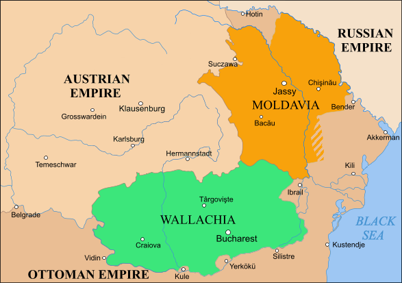
English: Moldavia, Wallachia and Transylvania between the Second Partition of Poland, 1793 and the Treaty of Bucharest, 1812 |
| 來源 | |
| 作者 |
授權條款
[編輯]
| 此檔案採用創用CC 姓名標示-相同方式分享 3.0 未在地化版本授權條款。 受免責聲明的約束。 | ||
| ||
| 已新增授權條款標題至此檔案,作為GFDL授權更新的一部份。 |

|
已授權您依據自由軟體基金會發行的無固定段落、封面文字和封底文字GNU自由文件授權條款1.2版或任意後續版本,對本檔進行複製、傳播和/或修改。該協議的副本列在GNU自由文件授權條款中。 受免責聲明的約束。 |

|
File:Danubian Principalities 1800.svg是本檔案的向量版本。 如果品質不低,就應該優先使用該檔案,而非PNG檔案。
File:Rom1793-1812.png → File:Danubian Principalities 1800.svg
更多資訊請參閱Help:SVG/zh。 |
 |
檔案歷史
點選日期/時間以檢視該時間的檔案版本。
| 日期/時間 | 縮圖 | 尺寸 | 使用者 | 備註 | |
|---|---|---|---|---|---|
| 目前 | 2023年10月8日 (日) 12:49 | | 587 × 413(78 KB) | Gyalu22(留言 | 貢獻) | Transylvania was part of the Austrian Empire |
| 2019年2月15日 (五) 16:57 |  | 587 × 413(91 KB) | Anonimu(留言 | 貢獻) | Reverted to version as of 10:18, 2 November 2018 (UTC) | |
| 2019年2月13日 (三) 17:13 |  | 587 × 413(106 KB) | Julieta39(留言 | 貢獻) | Since the maps of this time | |
| 2018年11月2日 (五) 10:18 |  | 587 × 413(91 KB) | Anonimu(留言 | 貢獻) | too much detail distract from subject. also,18th century maps are not generally accurate fo the region | |
| 2018年10月19日 (五) 14:58 |  | 587 × 413(113 KB) | Claude Zygiel(留言 | 貢獻) | More details since 18th century maps | |
| 2018年7月11日 (三) 23:26 |  | 587 × 413(91 KB) | Anonimu(留言 | 貢獻) | more accurate borders | |
| 2015年11月8日 (日) 17:22 |  | 588 × 413(89 KB) | Spiridon Ion Cepleanu(留言 | 貢獻) | Colours | |
| 2010年2月21日 (日) 21:05 |  | 588 × 413(51 KB) | Olahus(留言 | 貢獻) | Corrections on the borders to the Ottoman Empire. | |
| 2006年5月19日 (五) 21:01 |  | 588 × 413(29 KB) | Zserghei(留言 | 貢獻) | This image was copied from wikipedia:en. The original description was: == Summary == Moldavia, Wallachia and Transylvania between the Second Partition of Poland, 1793 and the Treaty of Bucharest, 1812 == Licensing == {{GFDL-self}} [[Category:Romania his | |
| 2006年4月9日 (日) 09:15 |  | 588 × 413(29 KB) | Daos~commonswiki(留言 | 貢獻) | Moldavia, Wallachia and Transylvania between the Second Partition of Poland, 1793 and the Treaty of Bucharest, 1812 |
無法覆蓋此檔案。
檔案用途
下列11個頁面有用到此檔案:
- Atlas of Moldova
- Atlas of Romania
- Atlas of Transylvania
- User:Alex:D/Project2
- User:J budissin/Uploads/BiH/2015 November 1-10
- User:J budissin/Uploads/BiH/2018 July 11-20
- User:J budissin/Uploads/BiH/2018 November 1-10
- User:J budissin/Uploads/BiH/2018 October 11-20
- User:J budissin/Uploads/BiH/2019 February 10-18
- User:Minorax/SVG available/2023 October 7-12
- File:Rom1793-1812 fr2.png
全域檔案使用狀況
以下其他 wiki 使用了這個檔案:
- ar.wikipedia.org 的使用狀況
- azb.wikipedia.org 的使用狀況
- be-tarask.wikipedia.org 的使用狀況
- ca.wikipedia.org 的使用狀況
- cs.wikipedia.org 的使用狀況
- da.wikipedia.org 的使用狀況
- de.wikipedia.org 的使用狀況
- el.wikipedia.org 的使用狀況
- en.wikipedia.org 的使用狀況
- es.wikipedia.org 的使用狀況
- et.wikipedia.org 的使用狀況
- fr.wikipedia.org 的使用狀況
- gl.wikipedia.org 的使用狀況
- he.wikipedia.org 的使用狀況
- hu.wikipedia.org 的使用狀況
- io.wikipedia.org 的使用狀況
- it.wikipedia.org 的使用狀況
- ja.wikipedia.org 的使用狀況
- la.wikipedia.org 的使用狀況
- lt.wikipedia.org 的使用狀況
- pnb.wikipedia.org 的使用狀況
- pt.wikipedia.org 的使用狀況
- ro.wikipedia.org 的使用狀況
檢視此檔案的更多全域使用狀況。