File:Roman-Persian Frontier in Late Antiquity.svg
Skočit na navigaci
Skočit na vyhledávání

Velikost tohoto PNG náhledu tohoto SVG souboru: 800 × 514 pixelů. Jiná rozlišení: 320 × 205 pixelů | 640 × 411 pixelů | 1 024 × 657 pixelů | 1 280 × 822 pixelů | 2 560 × 1 644 pixelů | 2 710 × 1 740 pixelů.
Původní soubor (soubor SVG, nominální rozměr: 2 710 × 1 740 pixelů, velikost souboru: 2 MB)
Popisky
Popisky
Přidejte jednořádkové vysvětlení, co tento soubor představuje
Popis[editovat]
| Popis |
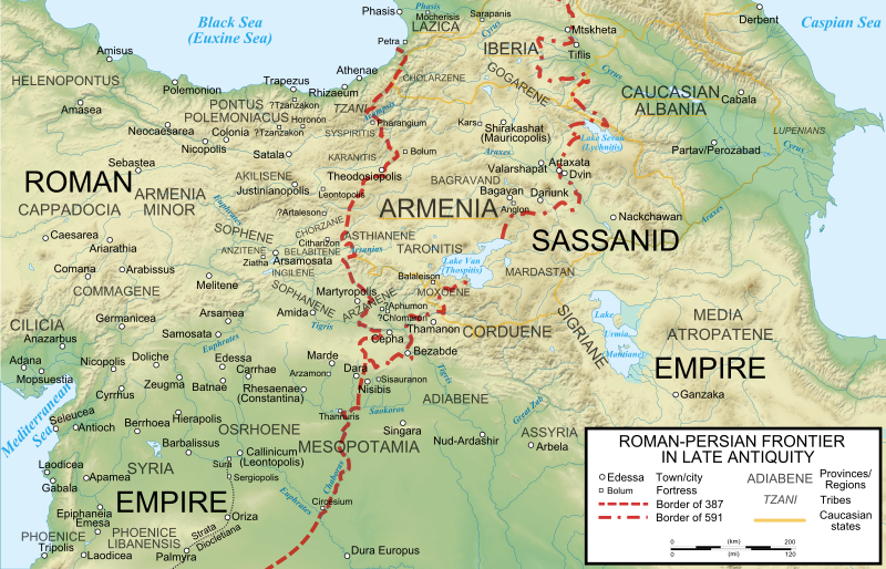
English: The frontier between the Roman/Byzantine and Sassanid Persian empires in Late Antiquity (4th-7th centuries). Basemap taken from Image:Arshakuni Armenia 150-en.svg. Sources: G. Greatrex & S.N.C. Lieu: The Roman Eastern Frontier and the Persian Wars (Part II, 363–630 AD). Routledge 2002, ISBN 0-415-14687-9, pp. xxix–xxxii; R.W. Thomson, J. Howard-Johnston & T. Greenwood: The Armenian history attributed to Sebeos Liverpool University Press 1999, ISBN 0-85323-564-3, pp. 360–363; Map of the cities listed in Hierocles' Synecdemus after Ernest Honigmann, Le Synecdèmos d'Hiéroclès et l'opuscule géographique de Georges de Chypre, Brussels 1939 |
| Datum | |
| Zdroj | Vlastní dílo |
| Autor | Cplakidas |
| Další verze |
[]
|


Licence[editovat]
Já, držitel autorských práv k tomuto dílu, ho tímto zveřejňuji za podmínek následujících licencí:
Tento soubor podléhá licenci Creative Commons Uveďte autora-Zachovejte licenci 3.0 Unported
- Dílo smíte:
- šířit – kopírovat, distribuovat a sdělovat veřejnosti
- upravovat – pozměňovat, doplňovat, využívat celé nebo částečně v jiných dílech
- Za těchto podmínek:
- uveďte autora – Máte povinnost uvést autorství, poskytnout odkaz na licenci a uvést, pokud jste provedli změny. Toho můžete docílit jakýmkoli rozumným způsobem, avšak ne způsobem naznačujícím, že by poskytovatel licence schvaloval nebo podporoval vás nebo vaše užití díla.
- zachovejte licenci – Pokud tento materiál jakkoliv upravíte, přepracujete nebo použijete ve svém díle, musíte své příspěvky šířit pod stejnou nebo slučitelnou licencí jako originál.

|
Tento dokument smí být kopírován, šířen nebo upravován podle podmínek Svobodné licence GNU pro dokumenty verze 1.2 nebo libovolné vyšší verze publikované nadací Free Software Foundation. Dokument nemá neměnné části ani texty na předním či zadním přebalu. Kopie textu licence je k dispozici v oddíle nazvaném GNU Free Documentation License. |
Můžete si zvolit libovolnou z těchto licencí.
Historie souboru
Kliknutím na datum a čas se zobrazí tehdejší verze souboru.
| Datum a čas | Náhled | Rozměry | Uživatel | Komentář | |
|---|---|---|---|---|---|
| současná | 5. 8. 2023, 14:27 | | 2 710 × 1 740 (2 MB) | Vikarna (diskuse | příspěvky) | fix img border |
| 25. 5. 2011, 07:01 |  | 2 710 × 1 740 (2 MB) | Cplakidas (diskuse | příspěvky) | fixing border between Dara & Nisibis | |
| 13. 11. 2010, 15:38 |  | 2 718 × 1 738 (2 MB) | Cplakidas (diskuse | příspěvky) | fixed image border | |
| 13. 11. 2010, 15:07 |  | 2 710 × 1 740 (2 MB) | Cplakidas (diskuse | příspěvky) | various slight tweaks, additions & corrections, river names to paths | |
| 11. 11. 2010, 16:01 |  | 2 710 × 1 740 (1,83 MB) | Cplakidas (diskuse | příspěvky) | minor tweaks | |
| 11. 11. 2010, 15:47 |  | 2 710 × 1 740 (1,8 MB) | Cplakidas (diskuse | příspěvky) | {{Information |Description={{en|1=The frontier between the Roman/Byzantine and Sassanid Persian empires in Late Antiquity (4th-7th centuries). Sources: G. Greatrex & S.N.C. Lieu: ''The Roman Eastern Frontier and the Persian Wars (Part II, 363–630 AD)''. |
Tento soubor nemůžete přepsat.
Využití souboru
Na Commons na soubor odkazují tyto stránky:
- Atlas of Kurdistan
- Atlas of Western Kurdistan
- Atlas of the Levant
- User:Cplakidas
- File:Roman-Persian Frontier in Late Antiquity-ar.svg
- File:Roman-Persian Frontier in Late Antiquity-es.svg
- File:Roman-Persian Frontier in Late Antiquity-fr.svg
- File:Roman-Persian Frontier in Late Antiquity-hu.svg
- File:Roman-Persian Frontier in Late Antiquity-pt.svg
- File:Roman-Persian Frontier in Late Antiquity-ru.svg
- File:Roman-Persian Frontier in Late Antiquity-zh.svg
- File:Roman-Persian Frontier in Late Antiquity.svg
- File:Segunda campanha de Sapor (253)-pt.svg
- Template:Other versions/Roman-Persian Frontier in Late Antiquity
- Category:Battle of Callinicum
-pt.svg)
Globální využití souboru
Tento soubor využívají následující wiki:
- Využití na af.wikipedia.org
- Využití na ar.wikipedia.org
- Využití na azb.wikipedia.org
- Využití na az.wikipedia.org
- Využití na bg.wikipedia.org
- Využití na ca.wikipedia.org
- Využití na cs.wikipedia.org
- Využití na de.wikipedia.org
- Využití na el.wikipedia.org
- Využití na en.wikipedia.org
Zobrazit další globální využití tohoto souboru.
Metadata
Kategorie:
- Maps of the Byzantine Levant
- Maps of the Sassanid Empire
- Maps of the history of Georgia
- SVG maps of the history of Armenia
- SVG maps of the history of Azerbaijan
- Maps of the history of the Caucasus in antiquity
- Maps of Caucasian Albania
- Maps of the Kingdom of Iberia
- Maps showing 6th-century history
- Persian-Roman wars
- Maps of Corduene
- Maps of Sophene
- Maps of Commagene
- SVG maps of the ancient Near East
- Maps of Osrhoene
- SVG maps of the Roman Empire