File:Roman Empire Map.png
ナビゲーションに移動
検索に移動
高解像度版はありません。
Roman_Empire_Map.png (800 × 548 ピクセル、ファイルサイズ: 44キロバイト、MIME タイプ: image/png)
キャプション
キャプション
このファイルの内容を1行で記述してください
概要
[編集]
| 解説 |
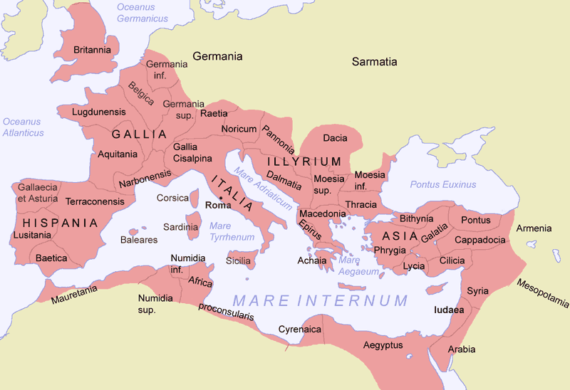
Deutsch: Römisches Reich um 117 zur Zeit Trajans
English: Roman empire around 117 AD.
Español: El Imperio Romano en su máxima extensión, durante el reinado de Trajano (hacia el 117)
Suomi: Rooman valtakunta |
| 日付 | |
| 原典 |
投稿者自身による著作物 |
| 作者 | Jani Niemenmaa |
| その他のバージョン |
|
ライセンス
[編集]

|
この文書は、フリーソフトウェア財団発行のGNUフリー文書利用許諾書 (GNU Free Documentation License) 1.2またはそれ以降のバージョンの規約に基づき、複製や再配布、改変が許可されます。不可変更部分、表紙、背表紙はありません。このライセンスの複製は、GNUフリー文書利用許諾書という章に含まれています。 |
| このファイルはクリエイティブ・コモンズ 表示-継承 3.0 非移植ライセンスのもとに利用を許諾されています。 | ||
| ||
| このライセンスのテンプレートは、GFDLのライセンス・アップデートによりこのファイルに追加されたものです。 |
ファイルの履歴
過去の版のファイルを表示するには、その版の日時をクリックしてください。
| 日付と時刻 | サムネイル | 寸法 | 利用者 | コメント | |
|---|---|---|---|---|---|
| 現在の版 | 2012年2月4日 (土) 15:11 | | 800 × 548 (44キロバイト) | AnonMoos (トーク | 投稿記録) | change "Palestina"[sic] to "Iudaea" -- term "Palaestina" did not come into official use until ca. 135 AD |
| 2007年7月17日 (火) 23:40 |  | 800 × 548 (45キロバイト) | ARTE (トーク | 投稿記録) | removed watermark | |
| 2005年1月10日 (月) 16:22 |  | 800 × 548 (69キロバイト) | Jniemenmaa (トーク | 投稿記録) | {{GFDL}} |
このファイルは上書きできません。
ファイルの使用状況
以下の 4 ページがこのファイルを使用しています:
グローバルなファイル使用状況
以下に挙げる他のウィキがこの画像を使っています:
- als.wikipedia.org での使用状況
- ar.wikipedia.org での使用状況
- ast.wikipedia.org での使用状況
- bat-smg.wikipedia.org での使用状況
- ba.wikipedia.org での使用状況
- be.wikipedia.org での使用状況
- bg.wikipedia.org での使用状況
- bn.wikibooks.org での使用状況
- br.wikipedia.org での使用状況
- ca.wikipedia.org での使用状況
- co.wikipedia.org での使用状況
- cs.wikipedia.org での使用状況
- cv.wikipedia.org での使用状況
- cy.wikipedia.org での使用状況
- da.wikipedia.org での使用状況
- de.wikipedia.org での使用状況
- de.wiktionary.org での使用状況
- dsb.wikipedia.org での使用状況
- el.wikipedia.org での使用状況
- en.wikipedia.org での使用状況
- en.wikibooks.org での使用状況
- en.wiktionary.org での使用状況
- eo.wikipedia.org での使用状況
- es.wikipedia.org での使用状況
- es.wikiversity.org での使用状況
このファイルのグローバル使用状況を表示する。
カテゴリ:
- Information graphics without data source
- Maps of the Roman Empire
- Maps of the history of Turkey
- Maps of the history of Georgia
- Maps of the history of Syria
- Maps of the history of Greece
- Maps of the history of France
- Maps of Roman Hispania
- Maps of the history of Germany (before 400)
- Latin-language maps showing history