File:Roman Republic Empire map.gif
维基共享资源,媒体文件资料库
跳转到导航
跳转到搜索
Roman_Republic_Empire_map.gif (626 × 595像素,文件大小:101 KB,MIME类型:image/gif、循环、21帧、37秒)
文件信息
结构化数据
说明
说明
添加一行文字以描述该文件所表现的内容
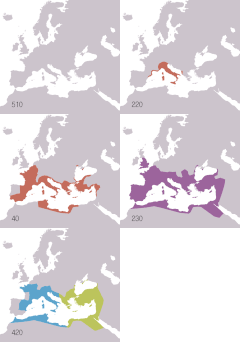
Animated map of the Roman Republic and Empire
Ρωμαϊκή αυτοκρατορία
La république romaine et son empire (510 av.jc/530ap.jc)
The Roman Republic and Empire (510BC-40BC).
Roma İmperiyası
La República y el Imperio Romanos (510 a. C.-530 d. C.)
Roman samarajya k naksha
Roma Cumhuriyeti ve İmparatorluğu'nun animasyonlu haritası. Haritada gösterilenler: Roma Cumhuriyeti MÖ 510-MÖ 40 Roma İmparatorluğu MS 20- MS 360 Doğu Roma İmparatorluğu MS 405-MS 1453 Batı Roma İmparatorluğu MS 405-MS 480
Römisches Reich
摘要
[编辑]| 描述Roman Republic Empire map.gif |
English: Animated map of the Roman Republic and Empire. Displayed in the map:
Español: Mapa animado de la República y el Imperio Romanos.
Français : Carte animée de la république puis de l'empire Romain. Русский: Анимированные карты Римской республики и империи. Отображаются на карте:
|
| 日期 | |
| 来源 |
English:
Español:
Français :
Русский: 日本語:
|
| 作者 | Roke (d) |
| 其他版本 |
English: Version including the Byzantine Empire is at Image:Roman Empire map.gif. Español: Image:Roman Empire map.gif: versión que incluye al Imperio Bizantino. Français : Image:Roman Empire map.gif : version incluant l'empire byzantin. Русский: В том числе версия Византийской империи: Image:Roman Empire map.gif 日本語: ビザンチン帝国を含む地図 : Image:Roman Empire map.gif。 |
| 相机位置 | 47° 00′ 00″ 北, 18° 00′ 00″ 东 | 在以下服务上查看本图像和附近其他图像: OpenStreetMap |
|---|
许可协议
[编辑]我,本作品著作权人,特此采用以下许可协议发表本作品:

|
已授权您依据自由软件基金会发行的无固定段落及封面封底文字(Invariant Sections, Front-Cover Texts, and Back-Cover Texts)的GNU自由文件许可协议1.2版或任意后续版本的条款,复制、传播和/或修改本文件。该协议的副本请见“GNU Free Documentation License”。http://www.gnu.org/copyleft/fdl.htmlGFDLGNU Free Documentation Licensetruetrue |
| 本文件采用知识共享署名-相同方式共享 3.0 未本地化版本许可协议授权。 | ||
| ||
| 本许可协议标签作为GFDL许可协议更新的组成部分被添加至本文件。http://creativecommons.org/licenses/by-sa/3.0/CC BY-SA 3.0Creative Commons Attribution-Share Alike 3.0truetrue |
文件历史
点击某个日期/时间查看对应时刻的文件。
| 日期/时间 | 缩略图 | 大小 | 用户 | 备注 | |
|---|---|---|---|---|---|
| 当前 | 2009年11月22日 (日) 19:14 |  | 626 × 595(101 KB) | Sémhur(留言 | 贡献) | Adding minus sign for BC years. |
| 2007年5月19日 (六) 09:56 |  | 626 × 595(101 KB) | Roke~commonswiki(留言 | 贡献) | minor - colours of numbers off in last version | |
| 2007年5月19日 (六) 07:31 |  | 626 × 595(71 KB) | Roke~commonswiki(留言 | 贡献) | fix area north of hadrians wall | |
| 2006年7月2日 (日) 14:29 |  | 800 × 760(218 KB) | Roke~commonswiki(留言 | 贡献) | Reverted to earlier revision | |
| 2006年6月6日 (二) 12:05 |  | 800 × 760(218 KB) | Roke~commonswiki(留言 | 贡献) | speed up rate to 1 second | |
| 2006年6月6日 (二) 10:58 |  | 800 × 760(218 KB) | Roke~commonswiki(留言 | 贡献) | map of the Roman Empire based on Image:BlankMap-Europe-v3.png, displayed in the map: *Red = Roman republic 510BC-40BC *Purple = Roman Empire 20AD-360AD *Blue = Western Roman Empire 4 |
您不可以覆盖此文件。
文件用途
以下8个页面使用本文件:
全域文件用途
以下其他wiki使用此文件:
- af.wikipedia.org上的用途
- am.wikipedia.org上的用途
- anp.wikipedia.org上的用途
- an.wikipedia.org上的用途
- ar.wikipedia.org上的用途
- arz.wikipedia.org上的用途
- ast.wikipedia.org上的用途
- azb.wikipedia.org上的用途
- az.wikipedia.org上的用途
- bar.wikipedia.org上的用途
- ba.wikipedia.org上的用途
- be-tarask.wikipedia.org上的用途
- be.wikipedia.org上的用途
- bg.wikipedia.org上的用途
- bn.wikipedia.org上的用途
- bs.wikipedia.org上的用途
- ca.wikipedia.org上的用途
- cdo.wikipedia.org上的用途
- ckb.wikipedia.org上的用途
- cs.wikipedia.org上的用途
- cv.wikipedia.org上的用途
- cy.wikipedia.org上的用途
- da.wikipedia.org上的用途
查看此文件的更多全域用途。
