File:Romania 1956-1990.svg
Pumunta sa nabigasyon
Pumunta sa paghahanap

Size of this PNG preview of this SVG file: 450 x 456 na pixel. Ibang resolusyon: 237 x 240 na pixel | 474 x 480 na pixel | 758 x 768 na pixel | 1,011 x 1,024 na pixel | 2,021 x 2,048 na pixel.
Orihinal na file (SVG na file, nominal na 450 × 456 (na) pixel, laki: 475 KB)
Captions
Captions
Add a one-line explanation of what this file represents
Buod[baguhin]


.svg)
.svg)
.svg)
.svg)
.svg)


.svg)
.svg)
.svg)


.png)
.png)


.svg)


.svg)

.svg)


.svg)
.svg)
.svg)
.svg)


.svg)
.png)


.svg)


.svg)
.svg)


.svg)


.svg)


.svg)
.svg)
.svg)
.svg)
.svg)
.svg)
.svg)
_cropped.svg)
.svg)
.svg)
.svg)
.svg)
.svg)
.svg)
.svg)
.svg)
.svg)
.svg)
.svg)
.svg)
.svg)
.svg)
.svg)
.svg)
.svg)
.svg)
.svg)
.svg)
.svg)
.svg)
.svg)
.svg)
.svg)
.svg)
.svg)
.svg)
.svg)
.svg)
.svg)
.svg)
.svg)
.svg)
.svg)
.svg)
.svg)
.svg)
.svg)
.svg)
.svg)
.svg)
.svg)
.svg)
.svg)
| This is a retouched picture, which means that it has been digitally altered from its original version. The original can be viewed here: Blank map of Europe 1956-1990.svg:
|
Paglilisensiya[baguhin]
Ako, na may karapatang-ari ng akdang ito, ang naglalathala nito alinsunod sa ilalim ng sumusunod na mga lisensya:
Lisensyado ang file na ito sa ilalim ng lisensiyang Creative Commons Attribution-Share Alike 3.0 Unported.
- Malaya kang:
- para ibahagi – para kopyahin, ipamahagi, at i-transmit ang akda
- para i-remix – para i-adapt ang akda
- Sa ilalim ng mga kondisyong ito:
- atribusyon – Dapat magbigay ka ng isang maayos na pag-credit, ibigay ang link sa lisensiya, at tukuyin kung may mga pagbabagong ginawa. Magagawa mo ito sa isang risonableng paraan, pero hindi sa paraan na para bang ineendorso ka o ng paggamit mo ng naglisensiya sa'yo.
- share alike – Kung ire-remix mo, babaguhin, o magdadagdag ka sa materyal, dapat mong ipamahagi ang mga ambag mo sa ilalim ng pareho o katulad na lisensiya.
Tala ng orihinal na pagkarga[baguhin]
This image is a derivative work of the following images:
- File:Blank_map_of_Europe_1956-1990.svg licensed with Cc-by-sa-3.0
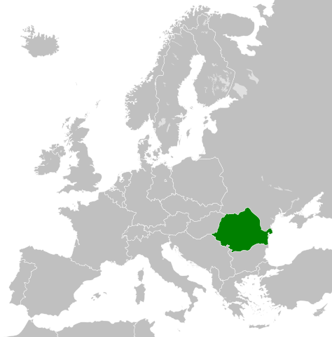
- 2011-10-30T04:43:42Z Alphathon 450x456 (485146 Bytes) == {{int:filedesc}} == {{Information |Description={{en|Blank map of Europe showing national borders as they stood from 1956-1990.}} |Source=*[[:File:Blank_map_of_Europe.svg|]] |Date=2011-10-30 04:42 (UTC) |Author=*[[:File:Bla
Nakaraan ng file
Pindutin ang isang petsa/oras para makita ang file noong puntong yon.
| Petsa/Oras | Thumbnail | Sukat | Tagagamit | Komento | |
|---|---|---|---|---|---|
| ngayon | 18:06, 30 Oktubre 2023 | | 450 × 456 (475 KB) | Rgvis (usapan | ambag) | Ceausescu demanded the cancellation of all agreements concluded during the Second World War with Nazi Germany, but without any modification of the borders: [https://www.mediafax.ro/revolutie-30/revolutions-la-congresul-al-xiv-lea-al-pcr-ceausescu-a-cerut-anularea-pactului-ribbentrop-molotov-partea-a-iii-a-18602951] |
| 17:01, 2 Mayo 2023 |  | 450 × 456 (480 KB) | Glide08 (usapan | ambag) | Reverted to version as of 17:25, 30 September 2022 (UTC) for a brief period between the 14 Congress of the PCR and the downfall of Ceausescu's regime, they did. The 14th congress of the PCR passed a resolution that demanded the annulment of the Molotov-Ribbentrop pact (which meant ceding Bessarabia back to Romania) | |
| 18:22, 1 Mayo 2023 |  | 450 × 456 (475 KB) | Trecătorul răcit (usapan | ambag) | The areas annexed by USSR (1940) were NOT claimed by the communist Romania during its existence (nor after).. | |
| 17:25, 30 Setyembre 2022 |  | 450 × 456 (480 KB) | Glide08 (usapan | ambag) | Added a mark for Bessarabia dn Northern Bukovina, claimed by Romania between the 14th Congress of the PCR and the Revolution | |
| 00:46, 26 Nobyembre 2011 |  | 450 × 456 (475 KB) | StalwartUK (usapan | ambag) | == {{int:filedesc}} == {{Information |Description={{en|Map of Communist Romania (Romanian People's Republic/Socialist Republic of Romania) as it was from 1947-1989. Surrounding countries accurate from 1956-1990.}} |Source=*[[:Fil |
Hindi mo mao-overwrite ang file na ito.
Paggamit sa file
Ginagamit ng sumusunod na pahina ang file na ito:
Pandaigdigang paggamit sa file
Ginagamit ng mga sumusunod na wiki ang file na ito:
- Paggamit sa als.wikipedia.org
- Paggamit sa ast.wikipedia.org
- Paggamit sa azb.wikipedia.org
- Paggamit sa az.wikipedia.org
- Paggamit sa be.wikipedia.org
- Paggamit sa bg.wikipedia.org
- Paggamit sa bn.wikipedia.org
- Paggamit sa ca.wikipedia.org
- Paggamit sa cs.wikipedia.org
- Paggamit sa cs.wikiquote.org
- Paggamit sa de.wikipedia.org
- Paggamit sa en.wikipedia.org
- Paggamit sa en.wikiquote.org
- Paggamit sa eo.wikipedia.org
- Paggamit sa es.wikipedia.org
- Paggamit sa et.wikipedia.org
- Paggamit sa fa.wikipedia.org
- Paggamit sa fi.wikipedia.org
- Paggamit sa fr.wikipedia.org
- Paggamit sa gl.wikipedia.org
- Paggamit sa he.wikipedia.org
- Paggamit sa id.wikipedia.org
- Paggamit sa it.wikipedia.org
- Paggamit sa ja.wikipedia.org
- Paggamit sa ko.wikipedia.org
- Paggamit sa lt.wikipedia.org
- Paggamit sa lv.wikipedia.org
- Paggamit sa nl.wikipedia.org
- Paggamit sa os.wikipedia.org
- Paggamit sa pnb.wikipedia.org
- Paggamit sa pt.wikipedia.org
- Paggamit sa ro.wikipedia.org
- Paggamit sa rue.wikipedia.org
- Paggamit sa ru.wikipedia.org
- Paggamit sa sc.wikipedia.org
- Paggamit sa simple.wikipedia.org
- Paggamit sa sk.wikipedia.org
- Paggamit sa sq.wikipedia.org
Tingnan ang karagdagang pandaigdigang paggamit sa file na ito.