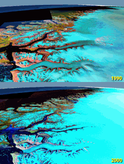
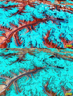
File:Rongbuk Glacier animation.gif

原始文件 (990 × 610像素,文件大小:1.68 MB,MIME类型:image/gif、循环、4帧、3.2秒)
说明
说明
摘要
[编辑]| 描述Rongbuk Glacier animation.gif |
English: Rongbuk (Rongphu) Glacier, Tibet; Mount Everest at the top right.
The lower ~10 km of the glacier is moraine-covered. Its terminus (snout) is near the bottom left at the source of the Rongbuk River. There is no snout retreat over this interval, but the large increase in the area of meltwater lakes on the glacier surface suggests significant thinning. The big lake in the 2010 image is nearly 2 km long. Also note the reduction in glacier cover on the foothills to the left. Stacked NASA World Wind images from the 1990 and 2000 NASA GeoCover collections and USGS Landsat 7 imagery from October 2009[1] (all Landsat 4/5 and Landsat 7 MSS/TM/ETM+ false-colour images). Diagonal lines in the 2010 image are due to the ETM+ scan line correction failure on Landsat 7. worldwind://goto/world=Earth&lat=28.07778&lon=86.88972&alt=19166&dir=92.2&tilt=31.6 (This is an animated GIF image. If animation is not visible, it may be because Microsoft Office Picture Manager has your GIF file association. That application does not support GIF animation. Change the association to any standard picture viewer, and restart your browser.) |
| 日期 | 2006年9月28日 (原始上传日期) |
| 来源 | 自己的作品. Made with NASA World Wind from NASA public domain imagery |
| 作者 | Glen Fergus |
Related glacier retreat images:
[编辑]
|
许可协议
[编辑]Made with NASA World Wind from NASA public domain imagery

|
已授权您依据自由软件基金会发行的无固定段落及封面封底文字(Invariant Sections, Front-Cover Texts, and Back-Cover Texts)的GNU自由文件许可协议1.2版或任意后续版本的条款,复制、传播和/或修改本文件。该协议的副本请见“GNU Free Documentation License”。http://www.gnu.org/copyleft/fdl.htmlGFDLGNU Free Documentation Licensetruetrue |
| 本文件采用知识共享署名-相同方式共享 3.0 未本地化版本许可协议授权。 | ||
| ||
| 本许可协议标签作为GFDL许可协议更新的组成部分被添加至本文件。http://creativecommons.org/licenses/by-sa/3.0/CC BY-SA 3.0Creative Commons Attribution-Share Alike 3.0truetrue |
文件历史
点击某个日期/时间查看对应时刻的文件。
| 日期/时间 | 缩略图 | 大小 | 用户 | 备注 | |
|---|---|---|---|---|---|
| 当前 | 2010年1月29日 (五) 06:11 |  | 990 × 610(1.68 MB) | Glen Fergus(留言 | 贡献) | Version 2 - 2010 |
| 2006年9月28日 (四) 11:07 |  | 992 × 654(950 KB) | Glen Fergus(留言 | 贡献) | == Summary == Rongbuk Glacier, Tibet. Mount Everest at the top right. The is no snout retreat over this interval, but the large increase in the area of meltwater lakes suggests significant thinning. Stacked NASA [[w:en:World W |
您不可以覆盖此文件。
文件用途
以下23个页面使用本文件:
- File:86.88972E 28.07778N.gif(文件重定向)
- File:Tasman Glacier.gif
- File:Puncak Jaya glaciers animation.gif
- File:Aletsch Glacier animation.gif
- File:Athabasca Glacier animation.gif
- File:Umiamako Glacier animation.gif
- File:San Rafael Glacier animation.gif
- File:Baltoro Glacier animation.gif
- File:Qori Kalis Glacier animation.gif
- File:Laguna San Rafael National Park glaciers animation.gif
- File:Southern Alps glaciers animation.gif
- File:Glacier Grey animation.gif
- File:Aletsch Glacier animation.gif
- File:Athabasca Glacier animation.gif
- File:Baltoro Glacier animation.gif
- File:Glacier Grey animation.gif
- File:Laguna San Rafael National Park glaciers animation.gif
- File:Puncak Jaya glaciers animation.gif
- File:Qori Kalis Glacier animation.gif
- File:San Rafael Glacier animation.gif
- File:Southern Alps glaciers animation.gif
- File:Tasman Glacier.gif
- File:Umiamako Glacier animation.gif
全域文件用途
以下其他wiki使用此文件:
- az.wikipedia.org上的用途
- cs.wikipedia.org上的用途
- en.wikipedia.org上的用途
- es.wikipedia.org上的用途
- it.wikipedia.org上的用途
- ml.wikipedia.org上的用途
- ru.wikipedia.org上的用途
- uk.wikipedia.org上的用途
- zh.wikipedia.org上的用途


