File:Rongbuk Glacier animation.gif
原始檔案 (990 × 610 像素,檔案大小:1.68 MB,MIME 類型:image/gif、循環、4 畫格、3.2秒)
說明
說明
摘要
[編輯]| 描述 |
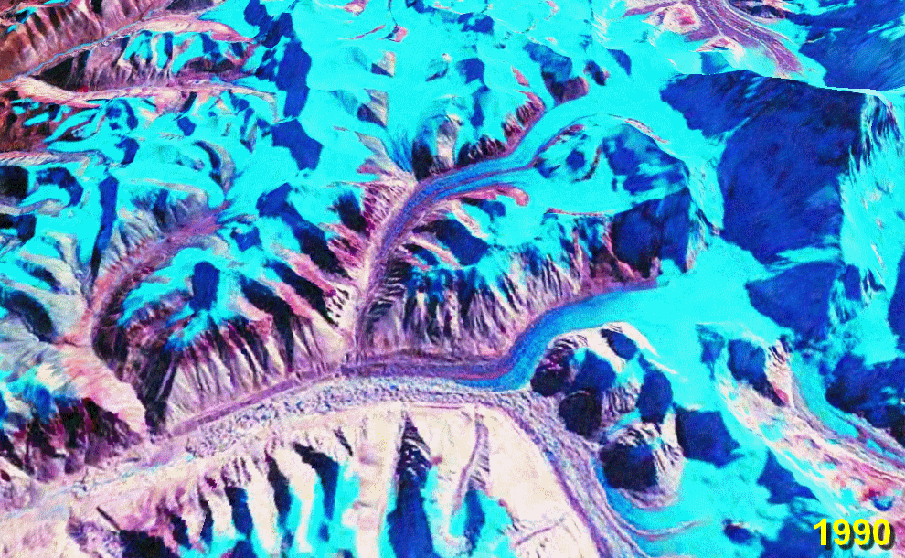
English: Rongbuk (Rongphu) Glacier, Tibet; Mount Everest at the top right.
The lower ~10 km of the glacier is moraine-covered. Its terminus (snout) is near the bottom left at the source of the Rongbuk River. There is no snout retreat over this interval, but the large increase in the area of meltwater lakes on the glacier surface suggests significant thinning. The big lake in the 2010 image is nearly 2 km long. Also note the reduction in glacier cover on the foothills to the left. Stacked NASA World Wind images from the 1990 and 2000 NASA GeoCover collections and USGS Landsat 7 imagery from October 2009[1] (all Landsat 4/5 and Landsat 7 MSS/TM/ETM+ false-colour images). Diagonal lines in the 2010 image are due to the ETM+ scan line correction failure on Landsat 7. worldwind://goto/world=Earth&lat=28.07778&lon=86.88972&alt=19166&dir=92.2&tilt=31.6 (This is an animated GIF image. If animation is not visible, it may be because Microsoft Office Picture Manager has your GIF file association. That application does not support GIF animation. Change the association to any standard picture viewer, and restart your browser.) |
| 日期 | 2006年9月28日 (原始上傳日期) |
| 來源 | 自己的作品. Made with NASA World Wind from NASA public domain imagery |
| 作者 | Glen Fergus |
Related glacier retreat images:
[編輯]
|


授權條款
[編輯]
Made with NASA World Wind from NASA public domain imagery

|
已授權您依據自由軟體基金會發行的無固定段落、封面文字和封底文字GNU自由文件授權條款1.2版或任意後續版本,對本檔進行複製、傳播和/或修改。該協議的副本列在GNU自由文件授權條款中。 |
| 此檔案採用創用CC 姓名標示-相同方式分享 3.0 未在地化版本授權條款。 | ||
| ||
| 已新增授權條款標題至此檔案,作為GFDL授權更新的一部份。 |
檔案歷史
點選日期/時間以檢視該時間的檔案版本。
| 日期/時間 | 縮圖 | 尺寸 | 使用者 | 備註 | |
|---|---|---|---|---|---|
| 目前 | 2010年1月29日 (五) 06:11 | | 990 × 610(1.68 MB) | Glen Fergus(留言 | 貢獻) | Version 2 - 2010 |
| 2006年9月28日 (四) 11:07 |  | 992 × 654(950 KB) | Glen Fergus(留言 | 貢獻) | == Summary == Rongbuk Glacier, Tibet. Mount Everest at the top right. The is no snout retreat over this interval, but the large increase in the area of meltwater lakes suggests significant thinning. Stacked NASA [[w:en:World W |
無法覆蓋此檔案。
檔案用途
下列23個頁面有用到此檔案:
- File:86.88972E 28.07778N.gif (檔案重新導向)
- File:Tasman Glacier.gif
- File:Puncak Jaya glaciers animation.gif
- File:Aletsch Glacier animation.gif
- File:Athabasca Glacier animation.gif
- File:Umiamako Glacier animation.gif
- File:San Rafael Glacier animation.gif
- File:Baltoro Glacier animation.gif
- File:Qori Kalis Glacier animation.gif
- File:Laguna San Rafael National Park glaciers animation.gif
- File:Southern Alps glaciers animation.gif
- File:Glacier Grey animation.gif
- File:Aletsch Glacier animation.gif
- File:Athabasca Glacier animation.gif
- File:Baltoro Glacier animation.gif
- File:Glacier Grey animation.gif
- File:Laguna San Rafael National Park glaciers animation.gif
- File:Puncak Jaya glaciers animation.gif
- File:Qori Kalis Glacier animation.gif
- File:San Rafael Glacier animation.gif
- File:Southern Alps glaciers animation.gif
- File:Tasman Glacier.gif
- File:Umiamako Glacier animation.gif
全域檔案使用狀況
以下其他 wiki 使用了這個檔案:
- az.wikipedia.org 的使用狀況
- cs.wikipedia.org 的使用狀況
- en.wikipedia.org 的使用狀況
- es.wikipedia.org 的使用狀況
- it.wikipedia.org 的使用狀況
- ml.wikipedia.org 的使用狀況
- ru.wikipedia.org 的使用狀況
- uk.wikipedia.org 的使用狀況
- zh.wikipedia.org 的使用狀況