File:Roze Glacier, Novaya Zemlya.jpg
Aller à la navigation
Aller à la recherche

Taille de cet aperçu : 768 × 600 pixels. Autres résolutions : 307 × 240 pixels | 615 × 480 pixels | 984 × 768 pixels | 1 280 × 1 000 pixels | 2 560 × 1 999 pixels | 4 222 × 3 297 pixels.
Fichier d’origine (4 222 × 3 297 pixels, taille du fichier : 1,32 Mio, type MIME : image/jpeg)
Légendes
Légendes
Ajoutez en une ligne la description de ce que représente ce fichier
Description[modifier]
| Description |
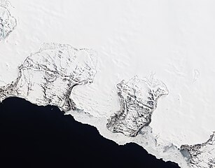
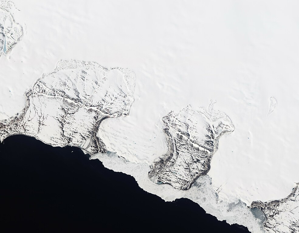
English: Natural-colour image of Roze Glacier fringed by sea ice. The image is rotated and north is toward the upper right. The glacier pushes slowly seaward between two rocky ridges. Uneven snow cover on the rock surfaces creates a patchwork of brown and white. Some snow also rests on the adjacent sea ice, which appears in shades of white and gray. In the east, a large patch of gray ice immediately offshore may owe its color to a layer of melt water or simply a lack of snow cover. On the glacier itself, isolated pools of melt water form ovals and slivers of blue-gray. Dwarfing the melt ponds, two long parallel stripes extend southward toward the coast. The stripes look like debris along the sides of a relatively fast-flowing ice stream, which may have picked up rocks and dirt from an upslope rock outcrop. |
| Date | |
| Source | NASA Earth Observatory |
| Auteur | Jesse Allen and Robert Simmon |
| Lieu de la prise de vue | | Voir cet endroit et d’autres images sur : OpenStreetMap |
|---|
Image captured by the Advanced Land Imager (ALI) on NASA’s Earth Observing-1 (EO-1) satellite. EO-1 ALI data provided courtesy of the NASA EO-1 team.
Conditions d’utilisation[modifier]
| Ce fichier provient de la NASA. Sauf exception, les documents créés par la NASA ne sont pas soumis à copyright. Pour plus d'informations, voir la politique de copyright de la NASA. | ||
 |
Attention :
|
Historique du fichier
Cliquer sur une date et heure pour voir le fichier tel qu'il était à ce moment-là.
| Date et heure | Vignette | Dimensions | Utilisateur | Commentaire | |
|---|---|---|---|---|---|
| actuel | 19 septembre 2011 à 14:31 | | 4 222 × 3 297 (1,32 Mio) | Originalwana (d | contributions) | {{Information |Description ={{en|1=Natural-colour image of Roze Glacier fringed by sea ice. The image is rotated and north is toward the upper right. The glacier pushes slowly seaward between two rocky ridges. Uneven snow cover on the rock |
Vous ne pouvez pas remplacer ce fichier.
Utilisations locales du fichier
Aucune page n’utilise ce fichier.
Utilisations du fichier sur d’autres wikis
Les autres wikis suivants utilisent ce fichier :
- Utilisation sur ceb.wikipedia.org
- Utilisation sur en.wikipedia.org
- Utilisation sur fr.wikipedia.org
- Utilisation sur ms.wikipedia.org
- Utilisation sur www.wikidata.org