File:Rs-map.png
Zur Navigation springen
Zur Suche springen
Kei höcheri Uflösig verfüegbar.
Rs-map.png (634 × 323 Pixel, Dateigrößi: 37 KB, MIME-Typ: image/png)
Bildtexte
Kurzbeschreibungen
Ergänze eine einzeilige Erklärung, was diese Datei darstellt.
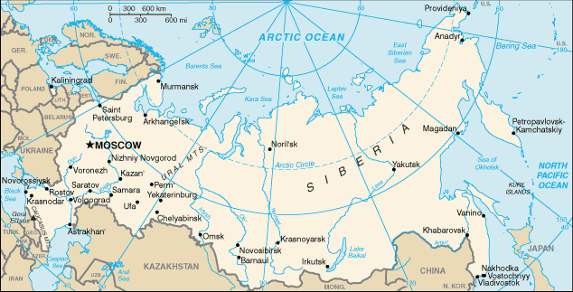
CIA map of Russia. https://www.cia.gov/library/publications/the-world-factbook/geos/rs.html archive copy at the Wayback Machine
This version of CIA World Factbook map has few changes compared to the previous version at Commons.
See also SVG version: Image:Blank map of Russia-geoloc.svg
Dieses Werk ist gemeinfrei, weil es Bildmaterial aus dem CIA World Factbook darstellt, das ursprünglich vom Zentralen Nachrichtendienst der Vereinigten Staaten veröffentlicht wurde.
|
 |
.jpg)
| Annotations | This image is annotated: View the annotations at Commons |
Dateiversione
Klick uf e Zytpunkt zu aazeige, wie s dert usgsäh het.
| Version vom | Vorschaubild | Mäß | Benutzer | Kommentar | |
|---|---|---|---|---|---|
| aktuell | 16:40, 16. Mei 2009 | | 634 × 323 (37 KB) | Pasixxxx (Diskussion | Byträg) | New version of this map from CIA World Factbook site. Few more cities, Yekaterinburg location has changed considerably compared to the Commons' previous version. From CIA World Factbook site [https://www.cia.gov/library/publications/the-world-factbook/geo |
| 15:50, 3. Dez. 2004 |  | 635 × 324 (29 KB) | Kneiphof (Diskussion | Byträg) | CIA map of Russia, PD |
Du chasch die Datei nit iberschryybe.
Verwändig vu dr Datei
Die 4 Syte bruuche die Datei:
Wältwyti Dateinutzig
Die andere Wikis bruche die Datei:
- Gebruch uf als.wikipedia.org
- Gebruch uf ar.wikipedia.org
- Gebruch uf ast.wikipedia.org
- Gebruch uf az.wiktionary.org
- Gebruch uf ceb.wikipedia.org
- Gebruch uf cs.wikipedia.org
- Gebruch uf de.wikipedia.org
- Gebruch uf diq.wikipedia.org
- Gebruch uf dsb.wikipedia.org
- Gebruch uf en.wikipedia.org
- Wikipedia:In the news/Candidates/December 2005
- List of twin towns and sister cities in Russia
- Wikipedia:Reference desk/Archives/Science/2007 July 18
- Northern river reversal
- Energy in Russia
- User:Epipelagic/sandbox/ref3
- Module talk:Location map/Archive 1
- User:Andrewjlockley/Hydraulic geoengineering2g
- User:Morriswa/My OCONUS travel
- User:Falcaorib
- Wikipedia:In the news/Posted/December 2005
- Gebruch uf en.wikibooks.org
- Gebruch uf en.wiktionary.org
- Gebruch uf es.wikipedia.org
- Gebruch uf fr.wikipedia.org
- Gebruch uf gl.wikipedia.org
- Gebruch uf he.wikipedia.org
- Gebruch uf hif.wikipedia.org
- Gebruch uf hu.wikipedia.org
Wältwyti Verwändig vu däre Datei aaluege.