File:SE2015Mar20T.png
跳去導覽
跳去搵嘢

預覽大細:599 × 600 像素。 第啲解像度:240 × 240 像素 | 479 × 480 像素 | 728 × 729 像素。
原本檔案 (728 × 729 像素,檔案大細:27 KB ,MIME類型:image/png)
Captions
Captions
Add a one-line explanation of what this file represents
摘要[編輯]
| 描述 |
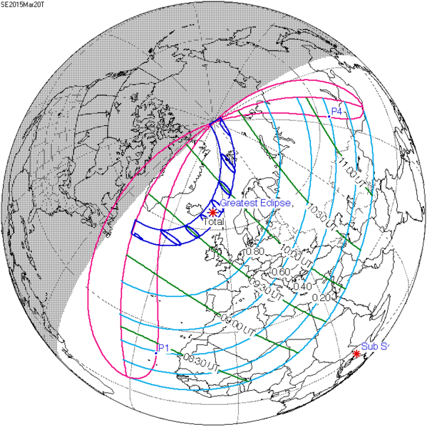
English: Solar eclipse A map of path on earth: Totality exists within the dark blue areas, partiality at the light blue areas. The eclipse occurs at sunrise or sunset in the pink areas. Light blue lines represent a constant fixed fraction of coverage. Green lines show lines of time for greatest coverage. For more information see [1] |
| 日期 | |
| 來源 | http://eclipse.gsfc.nasa.gov/ |
| 作者 | Eclipse Predictions by Fred Espenak, NASA's GSFC |
![[1]](http://eclipse.gsfc.nasa.gov/SEplot/SEplot2001/SE2015Mar20T.GIF)
協議[編輯]
| This file is in the public domain in the United States because it was solely created by NASA. NASA copyright policy states that "NASA material is not protected by copyright unless noted". (See Template:PD-USGov, NASA copyright policy page or JPL Image Use Policy.) | ||
 |
Warnings:
|
Original upload log[編輯]
The original description page was here. All following user names refer to en.wikipedia.
- 2009-12-08 20:37 SockPuppetForTomruen 728×729× (91056 bytes)
- 2009-11-22 07:43 Tomruen 733×729× (91478 bytes) {{Information |Description = [[Solar eclipse]] map of path on earth |Source = http://eclipse.gsfc.nasa.gov/ |Date = 2000 |Author = Fred |Permission = Official work for NASA |other_versions = }} {{Attribution}} Attribution: '''Eclipse Pr
檔案歷史
撳個日期/時間去睇響嗰個時間出現過嘅檔案。
| 日期/時間 | 縮圖 | 尺寸 | 用戶 | 註解 | |
|---|---|---|---|---|---|
| 現時 | 2015年7月16號 (四) 18:22 | | 728 × 729(27 KB) | Cmdrjameson(傾偈 | 貢獻) | Compressed with pngout. Reduced by 62kB (70% decrease). |
| 2011年8月9號 (二) 08:40 |  | 728 × 729(89 KB) | OgreBot(傾偈 | 貢獻) | (BOT): Reverting to most recent version; originally uploaded at en.wikipedia on 2009-12-08 20:37:41 by SockPuppetForTomruen | |
| 2011年8月9號 (二) 08:40 |  | 733 × 729(89 KB) | OgreBot(傾偈 | 貢獻) | (BOT): Uploading old version of file from en.wikipedia; originally uploaded on 2009-11-22 07:43:35 by Tomruen | |
| 2011年3月13號 (日) 10:13 |  | 728 × 729(89 KB) | SamZane(傾偈 | 貢獻) | {{Information |Description ={{en|1=Solar eclipse of march 20 2015 map.}} |Source =NASA |Author =NASA |Date = |Permission = |other_versions = }} Category:Solar eclipse map |
你無得衾咗個檔案。
檔案用途
無頁面用到呢個檔案。
全域檔案使用情況
下面嘅維基都用緊呢個檔案:
- ar.wikipedia.org嘅使用情況
- كسوف الشمس 20 مارس 2015
- كسوف الشمس 1 يونيو 2011
- كسوف الشمس 1 سبتمبر 2016
- كسوف الشمس 26 فبراير 2017
- كسوف الشمس 25 أكتوبر 2022
- كسوف الشمس 12 أغسطس 2026
- كسوف الشمس 30 مارس 2033
- كسوف الشمس 5 يناير 2038
- كسوف الشمس 25 أكتوبر 2041
- كسوف الشمس 12 أغسطس 2045
- كسوف الشمس 31 مايو 2049
- كسوف الشمس 11 أبريل 2051
- كسوف الشمس 20 مارس 2034
- كسوف الشمس 20 مارس 2053
- كسوف الشمس 12 أغسطس 2064
- كسوف الشمس 5 يناير 2057
- كسوف الشمس 24 أكتوبر 2060
- كسوف الشمس 31 مايو 2068
- كسوف الشمس 21 أبريل 2069
- كسوف الشمس 6 يناير 2019
- كسوف الشمس 2 مايو 2087
- كسوف الشمس 1 يونيو 2087
- كسوف الشمس 19 مارس 2072
- كسوف الشمس 7 فبراير 2073
- كسوف الشمس 3 أغسطس 2073
- كسوف الشمس 27 يناير 2074
- كسوف الشمس 6 يناير 2076
- كسوف الشمس 24 أكتوبر 2079
- كسوف الشمس 21 مارس 2080
- كسوف الشمس 13 سبتمبر 2080
- كسوف الشمس 10 مارس 2081
- كسوف الشمس 13 أغسطس 2083
- كسوف الشمس 7 يناير 2084
- كسوف الشمس 3 يوليو 2084
- كسوف الشمس 27 ديسمبر 2084
- كسوف الشمس 22 يونيو 2085
- كسوف الشمس 16 ديسمبر 2085
- az.wikipedia.org嘅使用情況
- be.wikipedia.org嘅使用情況
- bg.wikipedia.org嘅使用情況
- bn.wikipedia.org嘅使用情況
- el.wikipedia.org嘅使用情況
- en.wikipedia.org嘅使用情況
睇呢個檔案嘅更多全域使用情況。