File:SMOS2010.png
跳转到导航
跳转到搜索

本预览的尺寸:800 × 337像素。 其他分辨率:320 × 135像素 | 640 × 270像素 | 1,418 × 598像素。
原始文件 (1,418 × 598像素,文件大小:1,009 KB,MIME类型:image/png)
说明
说明
添加一行文字以描述该文件所表现的内容
摘要
[编辑]
| 描述 |
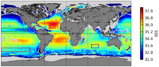
English: A map of surface salinity levels (between 32 and 38‰) recorded between August & September of 2010 and 2011 by the European Space Agency's Soil Moisture and Ocean Salinity (SMOS) satellite, the first such satellite in the world. [Cropped from source to remove non-released image.] |
| 日期 | |
| 来源 | "Sea Surface Salinity.jpg" at the European Space Agency's Space in Images |
| 作者 | SMOS GLOSCAL Cal/Val project |
许可协议
[编辑]

|
本文件的著作权人,允许任何人在适当地表明著作权人的姓名的前提下,以任何目的使用本文件。传播,演绎作品,商业用途及所有其他用途被允许。 |
|
|
Released 1 October 2012 at 12:14 pm.
Although commercial use is permitted, the ESA requests layout and copy be submitted to spaceinimages@esa.int to verify that the use of the image does not falsely state or imply ESA endorsement of a product, process, or service (i.e., violate fraud statutes).
文件历史
点击某个日期/时间查看对应时刻的文件。
| 日期/时间 | 缩略图 | 大小 | 用户 | 备注 | |
|---|---|---|---|---|---|
| 当前 | 2014年8月6日 (三) 05:39 | | 1,418 × 598(1,009 KB) | LlywelynII(留言 | 贡献) | User created page with UploadWizard |
您不可以覆盖此文件。
文件用途
没有页面使用本文件。
全域文件用途
以下其他wiki使用此文件:
- ar.wikipedia.org上的用途
- en.wikipedia.org上的用途
- fa.wikipedia.org上的用途
- gl.wikipedia.org上的用途
- pt.wikipedia.org上的用途
- sr.wikipedia.org上的用途
- www.wikidata.org上的用途
- zh.wikipedia.org上的用途