File:Sacajawea Patera PIA00485.jpg
跳转到导航
跳转到搜索
本预览的尺寸:750 × 600像素。 其他分辨率:300 × 240像素 | 600 × 480像素 | 960 × 768像素 | 1,280 × 1,024像素 | 1,880 × 1,504像素。
原始文件 (1,880 × 1,504像素,文件大小:696 KB,MIME类型:image/jpeg)
说明
说明
添加一行文字以描述该文件所表现的内容
摘要
[编辑]
| 描述 |
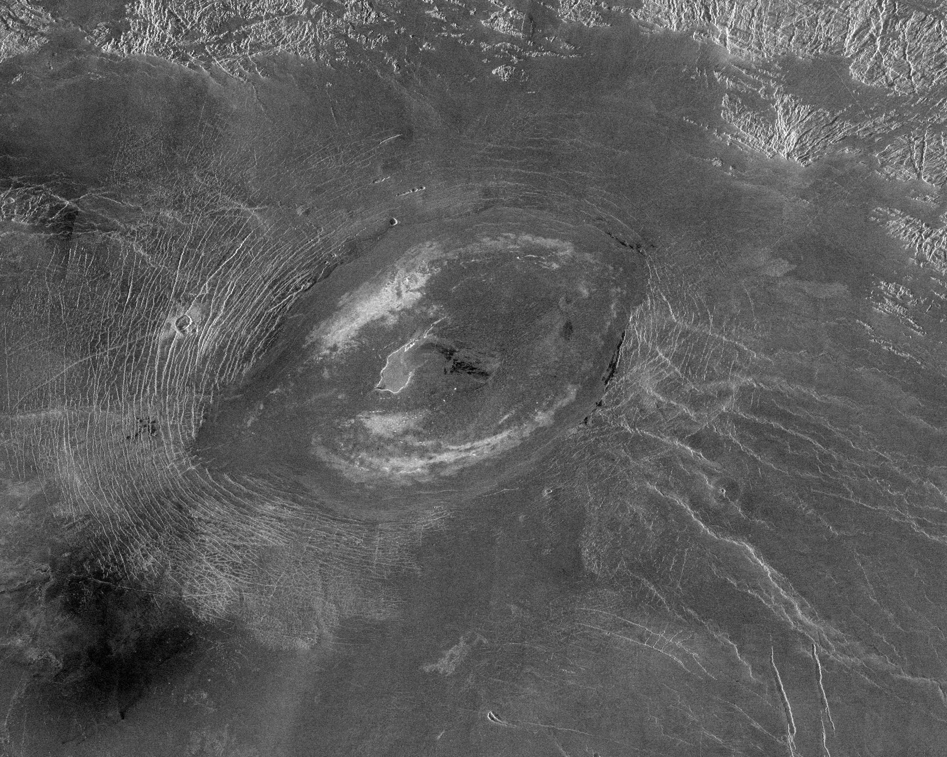
English: This Magellan image reveals Sacajawea Patera, a large, elongate caldera located in Western Ishtar Terra on the smooth plateau of Lakshmi Planum. The image is centered at 64.5 degrees North latitude and 337 degrees East longitude. It is approximately 420 kilometers (252 miles) wide at the base. Sacajawea is a depression approximately 1-2 kilometers (0.6-1.2 miles) deep and 120 x 215 kilometers (74 x 133 miles) in diameter; it is elongate in a southwest-northeast direction. The depression is bounded by a zone of circumferential curvilinear structures interpreted to be graben and fault scarps. These structures are spaced 0.5-4 kilometers (0.3-2.5 miles) apart, are 0.6-4.0 kilometers (0.4-2.5 miles) in width and up to 100 kilometers (62 miles) in length. Extending up to approximately 140 kilometers (87 miles) in length from the southeast of the patera is a system of linear structures thought to represent a flanking rift zone along which the lateral injection and eruption of magma may have occurred. A shield edifice 12 kilometers (7 miles) in diameter with a prominent central pit lies along the trend of one of these features. The impact crater Zlata, approximately 6 kilometers (4 miles) in diameter is located within the zone of graben to the northwest of the patera. Few flow features are observed in association with Sacajawea, possibly due to age and state of degradation of the flows. Mottled bright deposits 4-20 kilometers (2.5-12 miles) in width are located near the periphery and in the center of the patera floor within local topographic lows. Diffuse patches of dark material approximately 40 kilometers (25 miles) in width are observed southwest of the patera, superposed on portions of the surrounding graben. The formation of Sacajawea is thought to be related to the drainage and collapse of a large magma chamber. Gravitational relaxation may have caused the resultant caldera to sag, producing the numerous faults and graben that circumscribe the patera. Regions of complex, highly deformed tessera-like terrain are located north and east of the patera and are seen in the upper portion of the image. |
| 来源 | http://photojournal.jpl.nasa.gov/catalog/PIA00485 |
| 作者 | Magellan probe |
许可协议
[编辑]
| 本文件完全由NASA创作,在美国属于公有领域。根据NASA的版权方针,NASA的材料除非另有声明否则不受版权保护。(参见Template:PD-USGov/zh、NASA版权方针页面或JPL图片使用方针。) | ||
 |
警告:
|
文件历史
点击某个日期/时间查看对应时刻的文件。
| 日期/时间 | 缩略图 | 大小 | 用户 | 备注 | |
|---|---|---|---|---|---|
| 当前 | 2008年4月6日 (日) 22:02 | | 1,880 × 1,504(696 KB) | Bryan Derksen(留言 | 贡献) | {{Information |Description={{en|This Magellan image reveals Sacajawea Patera, a large, elongate caldera located in Western Ishtar Terra on the smooth plateau of Lakshmi Planum. The image is centered at 64.5 degrees North latitude and 337 degrees East long |
您不可以覆盖此文件。
文件用途
没有页面使用本文件。
全域文件用途
以下其他wiki使用此文件:
- cs.wikipedia.org上的用途
- en.wikipedia.org上的用途
- fr.wikipedia.org上的用途
- gl.wikipedia.org上的用途
- nl.wikipedia.org上的用途
- oc.wikipedia.org上的用途
- sr.wikipedia.org上的用途
- zh.wikipedia.org上的用途