File:Saemangeum 2004-01.jpg
出自Wikimedia Commons
跳至導覽
跳至搜尋
Saemangeum_2004-01.jpg (270 × 337 像素,檔案大小:20 KB,MIME 類型:image/jpeg)
檔案資訊
結構化資料
說明
說明
添加單行說明來描述出檔案所代表的內容
摘要
[編輯]| 描述Saemangeum 2004-01.jpg |
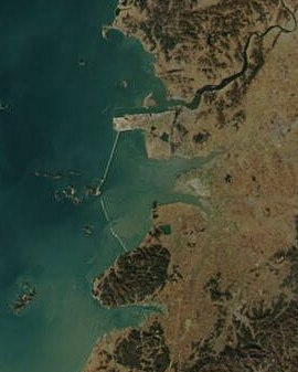
Deutsch: Küste der südkoreanischen Provinz Jeollabuk-do mit dem Saemangeum-Wattenmeer, aufgenommen im Januar 2004. In der Bildmitte ist der damals noch unterbrochene Damm sichtbar, der das Ästuar gegen das Gelbe Meer abschließt.
English: Saemangeum, Jeollabuk-do, South Korea in January 2004 showing incomplete dam. Filling in the estuary began in 1991. Dammed in April 2006.
한국어: 전라 북도 새만금 (2004년 1월)
|
| 日期 | |
| 來源 | Cropped from Hautala's Image:Satellite image of South Korea in January 2004.jpg, which was was in turn cropped from NASA's Visible Earth: http://visibleearth.nasa.gov/view_rec.php?id=6148 |
| 作者 | NASA |
授權條款
[編輯]| Public domainPublic domainfalsefalse |
| 本作品由NASA創作,屬於公有領域。根據NASA的版權政策:“NASA的創作除非另有聲明否則不受版權保護。”(參見:Template:PD-USGov/zh,NASA版權政策或JPL圖像使用政策) |  | |
 |
警告:
|
檔案歷史
點選日期/時間以檢視該時間的檔案版本。
| 日期/時間 | 縮圖 | 尺寸 | 用戶 | 備註 | |
|---|---|---|---|---|---|
| 目前 | 2006年10月5日 (四) 05:48 |  | 270 × 337(20 KB) | Dustsucker(對話 | 貢獻) | Cropped from Hautala's Image:Satellite image of South Korea in January 2004.jpg, which was was in turn cropped from NASA's Visible Earth: http://visibleearth.nasa.gov/cgi-bin/viewrecord?26220 |
無法覆蓋此檔案。
檔案用途
沒有使用此檔案的頁面。
全域檔案使用狀況
以下其他 wiki 使用了這個檔案:
- es.wikipedia.org 的使用狀況
- fr.wikipedia.org 的使用狀況
- id.wikipedia.org 的使用狀況
- it.wikipedia.org 的使用狀況
- mn.wikipedia.org 的使用狀況
- nl.wikipedia.org 的使用狀況
- no.wikipedia.org 的使用狀況
- zh.wikipedia.org 的使用狀況
詮釋資料
此檔案中包含其他資訊,這些資訊可能是由數位相機或掃描器在建立或數位化過程中所新增的。若檔案自原始狀態已被修改,一些詳細資料可能無法完整反映出已修改的檔案。
| _error | 0 |
|---|
