File:Saharat Thai Doem map.png
跳转到导航
跳转到搜索

本预览的尺寸:663 × 600像素。 其他分辨率:265 × 240像素 | 531 × 480像素 | 962 × 870像素。
原始文件 (962 × 870像素,文件大小:189 KB,MIME类型:image/png)
说明
说明
添加一行文字以描述该文件所表现的内容
摘要
[编辑]
| 描述 |
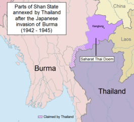
English: Parts of Shan State annexed by Thailand after the Japanese invasion of Burma. The map shows in purple the actual territories east of the Salween (Kengtung and part of Mongpan State) that were sanctioned by the Japanese authorities to become a new Thai province. Not all the territories claimed by Thailand in the Shan and Kayah states were granted by the Japanese.
Note: This is not a map of the farthest penetration of the Thai army accompanying the Japanese military in their Burma campaign. |
| 日期 | |
| 来源 | 自己的作品 |
| 作者 | Xufanc |
许可协议
[编辑]
我,本作品著作权人,特此采用以下许可协议发表本作品:
本文件采用知识共享署名-相同方式共享 4.0 国际许可协议授权。
- 您可以自由地:
- 共享 – 复制、发行并传播本作品
- 修改 – 改编作品
- 惟须遵守下列条件:
- 署名 – 您必须对作品进行署名,提供授权条款的链接,并说明是否对原始内容进行了更改。您可以用任何合理的方式来署名,但不得以任何方式表明许可人认可您或您的使用。
- 相同方式共享 – 如果您再混合、转换或者基于本作品进行创作,您必须以与原先许可协议相同或相兼容的许可协议分发您贡献的作品。
文件历史
点击某个日期/时间查看对应时刻的文件。
| 日期/时间 | 缩略图 | 大小 | 用户 | 备注 | |
|---|---|---|---|---|---|
| 当前 | 2017年5月24日 (三) 13:01 | | 962 × 870(189 KB) | Xufanc(留言 | 贡献) | Undid malicious revision by User:Shoshui |
| 2016年3月12日 (六) 03:37 |  | 962 × 870(167 KB) | Shoshui(留言 | 贡献) | Reverted to version as of 07:52, 6 November 2015 (UTC) | |
| 2015年12月15日 (二) 09:37 |  | 962 × 870(193 KB) | Xufanc(留言 | 贡献) | Corrected title | |
| 2015年12月15日 (二) 09:08 |  | 962 × 870(194 KB) | Xufanc(留言 | 贡献) | Other wording | |
| 2015年12月15日 (二) 08:59 |  | 962 × 870(208 KB) | Xufanc(留言 | 贡献) | Other wording | |
| 2015年11月9日 (一) 01:57 |  | 962 × 870(208 KB) | Xufanc(留言 | 贡献) | status unclear region | |
| 2015年11月7日 (六) 03:03 |  | 962 × 870(208 KB) | Xufanc(留言 | 贡献) | Status unclear region | |
| 2015年11月6日 (五) 07:52 |  | 962 × 870(167 KB) | Xufanc(留言 | 贡献) | Mandalay and Taunggiy was as far as the Thai troops advanced, but the map is about the parts annexed by Thailand as 'Saharat Thai Doem'. It is not a map of the farthest penetration of the Phayap Army | |
| 2015年9月14日 (一) 06:25 |  | 962 × 870(166 KB) | Shoshui(留言 | 贡献) | The area include Mandalay and Taunggyi. | |
| 2015年9月14日 (一) 06:16 |  | 962 × 870(166 KB) | Shoshui(留言 | 贡献) | The area include Mandalay and Taunggyi. |
您不可以覆盖此文件。
文件用途
以下6个页面使用本文件:
- User:Magog the Ogre/Maps of conflicts/2014 August
- User:Magog the Ogre/Maps of conflicts/2015 December
- User:Magog the Ogre/Maps of conflicts/2015 November
- User:Magog the Ogre/Maps of conflicts/2015 September
- User:Magog the Ogre/Maps of conflicts/2016 March
- User:Magog the Ogre/Maps of conflicts/2017 May
全域文件用途
以下其他wiki使用此文件:
- en.wikipedia.org上的用途
- es.wikipedia.org上的用途
- fr.wikipedia.org上的用途
- it.wikipedia.org上的用途
- my.wikipedia.org上的用途
- ru.wikipedia.org上的用途
- th.wikipedia.org上的用途
- uk.wikipedia.org上的用途
- vi.wikipedia.org上的用途
- zh.wikipedia.org上的用途