File:Saint Paul Island Alaska aerial view.jpg
Naviqasiyaya keç
Axtarışa keç

Sınaq göstərişi ölçüsü: 800 × 523 piksel. Digər ölçülər: 320 × 209 piksel | 640 × 419 piksel | 1.024 × 670 piksel | 1.500 × 981 piksel.
Faylın orijinalı (1.500 × 981 piksel, fayl həcmi: 589 KB, MIME növü: image/jpeg)
Captions
Captions
Add a one-line explanation of what this file represents
|
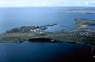
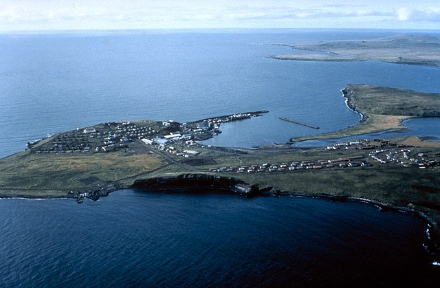
This is an image of a place or building that is listed on the National Register of Historic Places in the United States of America. Its reference number is 66000156. |
| İzah | Aerial view of St. Paul Island | |||
| Location | St. Paul Island, Alaska, USA |
|||
| Tarix | not specified or unknown | |||
| Mənbə |
U.S. Army Corps of Engineers Digital Visual Library Image page Image description page Digital Visual Library home page |
|||
| Müəllif | U.S. Army Corps of Engineers, photographer not specified or unknown | |||
| İcazə (Faylın təkrar istifadəsi) |
|
| Camera location | | View this and other nearby images on: OpenStreetMap |
|---|
| Object location | | View this and other nearby images on: OpenStreetMap |
|---|
Faylın tarixçəsi
Faylın əvvəlki versiyasını görmək üçün gün/tarix bölməsindəki tarixlərə klikləyin.
| Tarix/Vaxt | Miniatür | Ölçülər | İstifadəçi | Şərh | |
|---|---|---|---|---|---|
| hal-hazırkı | 01:44, 20 mart 2007 | | 1.500 × 981 (589 KB) | DanMS (müzakirə | töhfələr) | {{Information | Description = Aerial view of St. Paul Island | Source = U.S. Army Corps of Engineers Digital Visual Library<br />[http://images.usace.army.mil/images/Hires/4414-19.Jpg Image page]<br />[http://images.usace.army.mil/scripts/PortW |
Siz bu faylı yenidən yükləyə bilməzsiniz.
Faylın istifadəsi
Bu faylı istifadə edən səhifə yoxdur.
Faylın qlobal istifadəsi
Bu fayl aşağıdakı vikilərdə istifadə olunur:
- az.wikipedia.org layihəsində istifadəsi
- be.wikipedia.org layihəsində istifadəsi
- br.wikipedia.org layihəsində istifadəsi
- ceb.wikipedia.org layihəsində istifadəsi
- de.wikipedia.org layihəsində istifadəsi
- en.wikipedia.org layihəsində istifadəsi
- es.wikipedia.org layihəsində istifadəsi
- fi.wikipedia.org layihəsində istifadəsi
- fr.wikipedia.org layihəsində istifadəsi
- gl.wikipedia.org layihəsində istifadəsi
- ja.wikipedia.org layihəsində istifadəsi
- pt.wikipedia.org layihəsində istifadəsi
- ru.wikipedia.org layihəsində istifadəsi
- www.wikidata.org layihəsində istifadəsi
- zh.wikipedia.org layihəsində istifadəsi