File:Saint Pierre and Miquelon map.gif
Saint_Pierre_and_Miquelon_map.gif (330 × 354 პიქსელი, ფაილის ზომა: 7 კბ, MIME ტიპი: image/gif)
Captions
Captions
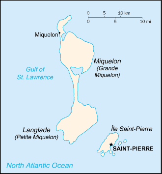
This is a map of Saint-Pierre and Miquelon from the CIA World Factbook (retrieved from https://www.cia.gov/library/publications/the-world-factbook/geos/sb.html Archived 2008-03-06 at Archive-It). According to the copyright notice on the website, all information of the World Factbook is in the public domain.
| Public domainPublic domainfalsefalse |
ეს სურათი განთავსებულია საზოგადოებრივ დომენში რადგან ის შეიცავს მასალას რომელიც თავდაპირველად მოვიდა აშშ-ის ცენტრალური სადაზვერვო სააგენტოს World Factbook-დან.
Bahasa Indonesia ∙ čeština ∙ Deutsch ∙ eesti ∙ English ∙ español ∙ Esperanto ∙ français ∙ galego ∙ hrvatski ∙ italiano ∙ Nederlands ∙ norsk nynorsk ∙ polski ∙ português ∙ sicilianu ∙ slovenščina ∙ suomi ∙ Türkçe ∙ Zazaki ∙ беларуская (тарашкевіца) ∙ македонски ∙ русский ∙ српски / srpski ∙ українська ∙ ქართული ∙ বাংলা ∙ தமிழ் ∙ മലയാളം ∙ 한국어 ∙ 日本語 ∙ 中文 ∙ 中文(简体) ∙ 中文(繁體) ∙ العربية ∙ +/− |
 |
ფაილის ისტორია
დააწკაპუნეთ თარიღზე/დროზე, რათა იხილოთ ფაილი, როგორც ის მაშინ გამოიყურებოდა.
| თარიღი/დრო | მინიატიურა | განზომილებები | მომხმარებელი | კომენტარი | |
|---|---|---|---|---|---|
| მიმდინარე | 08:08, 26 ივნისი 2005 |  | 330 × 354 (7 კბ) | Taichi (განხილვა | წვლილი) | This is a map of Saint-Pierre and Miquelon from the CIA World Factbook (retrieved from http://www.cia.gov/cia/publications/factbook/geos/sb.html). According to the copyright notice on the website, all information of the World Factbook is in the public do |
თქვენ არ შეგიძლიათ ამ ფაილზე გადაწერა.
ფაილის გამოყენება
მომდევნო გვერდი იყენებს ამ ფაილს:
- File:Map of Saint Pierre and Miquelon.gif (ფაილის გადამისამართება)
ფაილის გლობალური გამოყენება
ეს ფაილი გამოიყენება შემდეგ ვიკებში:
- გამოყენება be-tarask.wikipedia.org-ში
- გამოყენება be.wikipedia.org-ში
- გამოყენება bn.wikipedia.org-ში
- გამოყენება ca.wikipedia.org-ში
- გამოყენება cs.wikipedia.org-ში
- გამოყენება dsb.wikipedia.org-ში
- გამოყენება el.wikipedia.org-ში
- გამოყენება en.wikipedia.org-ში
- გამოყენება eo.wikipedia.org-ში
- გამოყენება es.wikipedia.org-ში
- გამოყენება eu.wikipedia.org-ში
- გამოყენება fa.wikipedia.org-ში
- გამოყენება fi.wikipedia.org-ში
- გამოყენება fo.wikipedia.org-ში
- გამოყენება fr.wikipedia.org-ში
- გამოყენება hu.wikipedia.org-ში
- გამოყენება id.wikipedia.org-ში
- გამოყენება incubator.wikimedia.org-ში
- გამოყენება io.wikipedia.org-ში
- გამოყენება it.wikipedia.org-ში
- გამოყენება ja.wikipedia.org-ში
- გამოყენება kk.wikipedia.org-ში
- გამოყენება ko.wikipedia.org-ში
- გამოყენება ko.wiktionary.org-ში
- გამოყენება lt.wikipedia.org-ში
- გამოყენება mk.wikipedia.org-ში
- გამოყენება nl.wikipedia.org-ში
- გამოყენება nn.wikipedia.org-ში
- გამოყენება no.wikipedia.org-ში
- გამოყენება os.wikipedia.org-ში
- გამოყენება pl.wikipedia.org-ში
- გამოყენება pl.wiktionary.org-ში
იხილეთ, ამ ფაილის გლობალური გამოყენება.
