File:Saltonseadrainagemap.jpg
跳至導覽
跳至搜尋
預覽大小:638 × 600 像素。 其他解析度:255 × 240 像素 | 511 × 480 像素 | 782 × 735 像素。
原始檔案 (782 × 735 像素,檔案大小:278 KB,MIME 類型:image/jpeg)
說明
說明
添加單行說明來描述出檔案所代表的內容
摘要
[編輯]| 描述 |
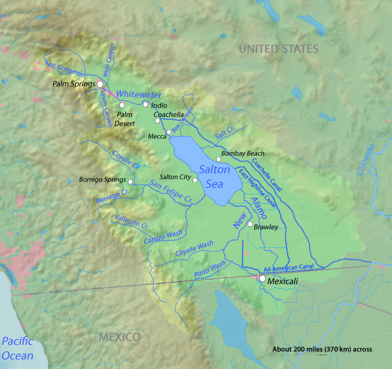
English: Map of the Salton Sea drainage area in the Salton Sink endorheic basin.
|
| 日期 | |
| 來源 | Background and river course data from http://www2.demis.nl/mapserver/mapper.asp and some topography from http://seamless.usgs.gov/website/seamless/viewer.htm |
| 作者 | Shannon |

|
本圖片是以PNG、GIF或JPEG格式上傳。然而,其中包含的資料或訊息,應該重新建立成可縮放向量圖形(SVG)檔案,以更有效率或更準確的方式儲存。如有可能,請上傳本圖片的SVG格式版本。在上傳之後,請修改維基各姊妹計畫中所有使用舊版圖片的條目(列在圖像連結章節中),替換為新版圖片,並在舊圖片的描述頁中加入{{Vector version available|新圖片名稱.svg}}模板,同時移除本模板。
|


授權條款
[編輯]
我,本作品的著作權持有者,決定用以下授權條款發佈本作品:

|
已授權您依據自由軟體基金會發行的無固定段落、封面文字和封底文字GNU自由文件授權條款1.2版或任意後續版本,對本檔進行複製、傳播和/或修改。該協議的副本列在GNU自由文件授權條款中。 |
This file is licensed under the Creative Commons Attribution-Share Alike Attribution-Share Alike 4.0 International, 3.0 Unported, 2.5 Generic, 2.0 Generic and 1.0 Generic license.
- 您可以自由:
- 分享 – 複製、發佈和傳播本作品
- 重新修改 – 創作演繹作品
- 惟需遵照下列條件:
- 姓名標示 – 您必須指名出正確的製作者,和提供授權條款的連結,以及表示是否有對內容上做出變更。您可以用任何合理的方式來行動,但不得以任何方式表明授權條款是對您許可或是由您所使用。
- 相同方式分享 – 如果您利用本素材進行再混合、轉換或創作,您必須基於如同原先的相同或兼容的條款,來分布您的貢獻成品。
您可以選擇您需要的授權條款。
檔案歷史
點選日期/時間以檢視該時間的檔案版本。
| 日期/時間 | 縮圖 | 尺寸 | 用戶 | 備註 | |
|---|---|---|---|---|---|
| 目前 | 2010年3月11日 (四) 02:37 | | 782 × 735(278 KB) | Shannon1(對話 | 貢獻) | {{Information |Description={{en|1=Map of the Salton Sea drainage area, with New, Whitewater, Alamo and other rivers, as well as All-American, Coachella and East Highline Canals included}} |Source=Background and river course data from http://www2.demis.nl/ |
無法覆蓋此檔案。
檔案用途
下列頁面有用到此檔案:
全域檔案使用狀況
以下其他 wiki 使用了這個檔案:
- af.wikipedia.org 的使用狀況
- bg.wikipedia.org 的使用狀況
- bs.wikipedia.org 的使用狀況
- ca.wikipedia.org 的使用狀況
- ceb.wikipedia.org 的使用狀況
- cs.wikipedia.org 的使用狀況
- de.wikipedia.org 的使用狀況
- en.wikipedia.org 的使用狀況
- eo.wikipedia.org 的使用狀況
- es.wikipedia.org 的使用狀況
- fa.wikipedia.org 的使用狀況
- fi.wikipedia.org 的使用狀況
- fr.wikipedia.org 的使用狀況
- gl.wikipedia.org 的使用狀況
- he.wikipedia.org 的使用狀況
- hu.wikipedia.org 的使用狀況
- ja.wikipedia.org 的使用狀況
- nl.wikipedia.org 的使用狀況
- pl.wikipedia.org 的使用狀況
- vi.wikipedia.org 的使用狀況
- war.wikipedia.org 的使用狀況
- www.wikidata.org 的使用狀況
- xmf.wikipedia.org 的使用狀況
- zh.wikipedia.org 的使用狀況
詮釋資料
分類:
- Maps of the Salton Sea
- Salton Sink
- Maps of rivers in California
- Maps of Imperial County, California
- Maps of Riverside County, California
- Geography of Imperial County, California
- Geography of Riverside County, California
- All-American Canal
- Coachella Valley
- Imperial Valley
- Laguna Salada (Mexico)
- Hydrology of California