File:Salty plain in Bolivia.jpg

原始文件 (1,676 × 1,676像素,文件大小:1.77 MB,MIME类型:image/jpeg)
说明
说明
摘要
[编辑]
| Salty plain in Bolivia | |
|---|---|
| 攝影師 |
Envisat satellite |
| 标题 |
Salty plain in Bolivia |
| 描述 |
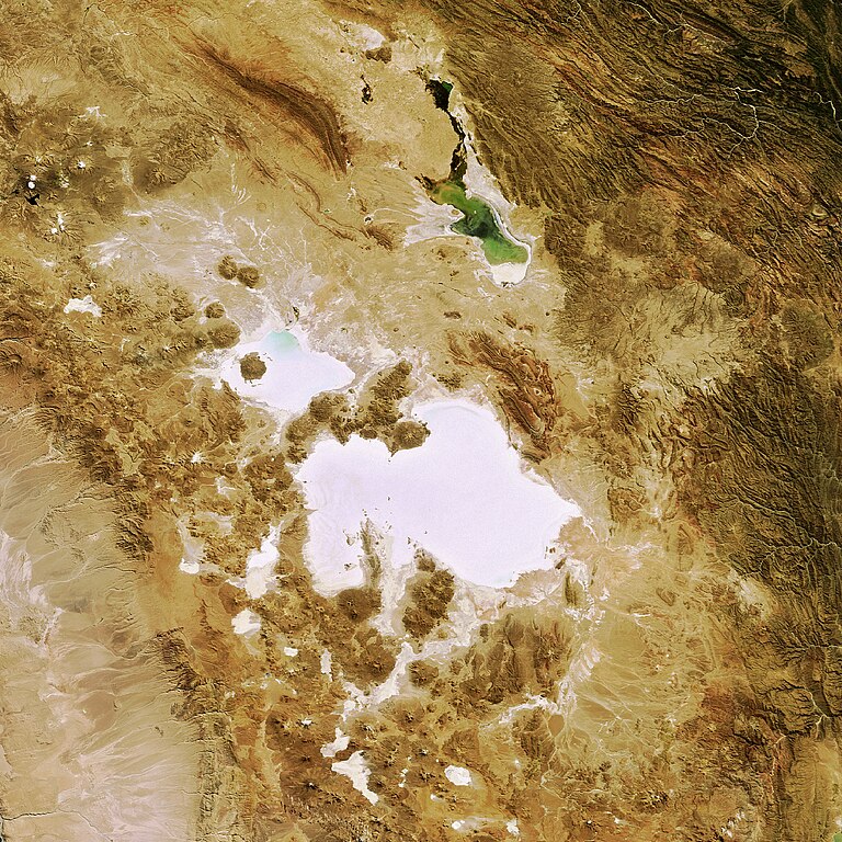
English: This Envisat image features salt flats in the Department of Potosi in southwest Bolivia, near the crest of the Andes Mountains.
The Salar de Uyuni (the lower white area) is the largest salt flat in the world, occupying 10 582 sq km. It is located at the southern end of the Altiplano, a high plain of inland drainage in the central Andes. Some 40 000 years ago, this area was part of a giant prehistoric lake that dried out, leaving behind two salt flats, the Uyuni and the Salar de Coipasa (visible above Uyuni), as well as two modern lakes, Poopó (visible in green) and Uru Uru. Occupying 2218 sq km, Salar de Coipasa is Bolivia's second largest salt flat. Stretching 90 km in length and 32 km in width, Lake Poopó is the country's second largest lake with the permanent part of its body covering approximately 1000 sq km. This image was acquired by Envisat’s Medium Resolution Imaging Spectrometer (MERIS) instrument on 7 May 2008 working in Full Resolution mode to provide a spatial resolution of 300 m. |
| 描绘地点 | 玻利維亞 |
| 日期 | 2008年5月7日 |
| 藏于 | European Space Agency |
| 登录号 |
239593 |
| 荣誉行 | ESA |
| 来源 | http://www.esa.int/spaceinimages/Images/2008/05/Salty_plain_in_Bolivia |
许可协议
[编辑]
- 您可以自由地:
- 共享 – 复制、发行并传播本作品
- 修改 – 改编作品
- 惟须遵守下列条件:
- 署名 – 您必须对作品进行署名,提供授权条款的链接,并说明是否对原始内容进行了更改。您可以用任何合理的方式来署名,但不得以任何方式表明许可人认可您或您的使用。
- 相同方式共享 – 如果您再混合、转换或者基于本作品进行创作,您必须以与原先许可协议相同或相兼容的许可协议分发您贡献的作品。
文件历史
点击某个日期/时间查看对应时刻的文件。
| 日期/时间 | 缩略图 | 大小 | 用户 | 备注 | |
|---|---|---|---|---|---|
| 当前 | 2017年3月7日 (二) 10:12 | | 1,676 × 1,676(1.77 MB) | Revent(留言 | 贡献) | =={{int:filedesc}}== {{Photograph |photographer = Envisat satellite |title = Salty plain in Bolivia |description = {{en|1=This Envisat image features salt flats in the Department of Potosi in southwest Bolivia, near the cre... |
您不可以覆盖此文件。
文件用途
以下4个页面使用本文件:
全域文件用途
以下其他wiki使用此文件:
- zh.wikipedia.org上的用途