File:Satellite image map of Mayak.jpg
Przejdź do nawigacji
Przejdź do wyszukiwania

Rozmiar podglądu – 800 × 509 pikseli. Inne rozdzielczości: 320 × 204 pikseli | 640 × 408 pikseli | 1024 × 652 pikseli | 1448 × 922 pikseli.
Rozmiar pierwotny (1448 × 922 pikseli, rozmiar pliku: 290 KB, typ MIME: image/jpeg)
Podpisy
Podpisy
Dodaj jednolinijkowe objaśnienie tego, co ten plik pokazuje
most radioactive place on Earth
| Opis |
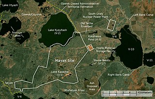
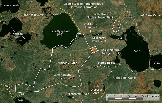
English: Satellite image/map of the Mayak nuclear facility, the closed town of Ozyorsk/Ozersk (Chelyabinsk-65), different lakes and reservoirs, and the South Urals nuclear power plant.
Based on a screenshot from NASA World Wind (Landsat Global Mosaic visual layer), color corrected.
Deutsch: Satellitenfoto/Karte der kerntechnischen Anlage Majak, der geschlossenen Stadt Osjorsk (Tscheljabinsk-65), verschiedenen Seen und Reservoirs sowie dem Kernkraftwerk Süd-Ural.
Basierend auf einem Screenshot aus NASA World Wind (Landsat Global Mosaic visual layer), farbkorrigiert. |
|||||
| Data | ||||||
| Źródło | NASA World Wind screenshot (Landsat Global Mosaic visual layer) | |||||
| Autor | NASA, Jan Rieke (color correction, borders and labels) | |||||
| Licencja (Ponowne użycie tego pliku) |
|
|||||
| Inne wersje | File:Majak Satellitenkarte.jpg |

| To zdjęcie było poddane obróbce cyfrowej i może różnić się od wersji oryginalnej. Zmiany: color correction, labeling. Modyfikacje zostały wykonane przez użytkownika JanRieke.
|
| Pozycja fotografa | | To i inne zdjęcia na: OpenStreetMap |
|---|
Credit appreciated when reusing this image.
Sources
[edytuj]
Primary Sources
[edytuj]
- Igor Kudrik, Aleksandr Nikitin, Charles Digges, Nils Bøhmer, Vladislav Larin, Vladimir Kuznetsov: The Russian Nuclear Industry – The Need for Reform. Bellona Report Volume 4:2004. Bellona Foundation, pp. 47–69, November 1, 2004
- Map of the system of dams and drainage channels at Mayak., in: AMAP Assessment Report: Arctic Pollution Issues, Arctic Monitoring & Assessment Programme, Working Group of the Arctic Council, 1998
- Dmitriy Burmistrov, Mira Kossenko, Richard Wilson: Radioactive Contamination of the Techa River and its Effects. archive copy at the Wayback Machine Technology, Vol. 7, pp. 553-575, 2000
Secondary Sources
[edytuj]
Location of V-6
[edytuj]
- B. Gusakov, A. Demin, M. Zawadzki, V. Kalinkin, A. Kirsanov, N. Shafrova: Решение экологических проблем Теченского каскада водоемов на ПО "Маяк"., December 19, 2006
Ash Disposal Area
[edytuj]
- A. R. Hutter: Radioactive contamination distribution in the bottom sediments and water of the Mishelyak River[martwy link], Journal of Radioanalytical and Nuclear Chemistry, 2001
- O. Aleksandrova: Natural remediation of surface water systems used as deposits of nuclear industry waste by humic substances, Dissertation, University of Osnabrück, 2009
Historia pliku
Kliknij na odpowiedniej dacie/czasie, aby zobaczyć wersję pliku z tamtego okresu.
| Data/czas | Miniatura | Wymiary | Użytkownik | Opis | |
|---|---|---|---|---|---|
| aktualny | 03:45, 28 lis 2010 | | 1448 × 922 (290 KB) | JanRieke (dyskusja | edycje) | included courses of rivers, yellow color for closed city borders, slightly reduced brightness, minor other changes |
| 22:12, 14 maj 2010 |  | 1448 × 922 (275 KB) | JanRieke (dyskusja | edycje) | label for Mishelyak River, removed name of V-4 due to contradictory sources | |
| 03:00, 9 maj 2010 |  | 1448 × 922 (275 KB) | JanRieke (dyskusja | edycje) | Minor improvements: alternative spelling of Ozersk "Ozyorsk", incr. font size for Mayak, ash disposal area, transparency for scale | |
| 23:44, 30 kwi 2010 |  | 1448 × 922 (272 KB) | JanRieke (dyskusja | edycje) | {{Information |Description={{en|1=Satellite image/map of the Mayak nuclear facility, the closed town of Ozersk (Chelyabinsk-65), different lakes and reservoirs, and the South Urals nuclear power plant. Based on a screenshot from NASA World Wind (Landsat G |
Nie możesz nadpisać tego pliku.
Lokalne wykorzystanie pliku
Następujące strony korzystają z tego pliku:
Globalne wykorzystanie pliku
Ten plik jest wykorzystywany także w innych projektach wiki:
- Wykorzystanie na ar.wikipedia.org
- Wykorzystanie na cs.wikipedia.org
- Wykorzystanie na da.wikipedia.org
- Wykorzystanie na de.wikipedia.org
- Wykorzystanie na en.wikipedia.org
- Wykorzystanie na eu.wikipedia.org
- Wykorzystanie na fa.wikipedia.org
- Wykorzystanie na fi.wikipedia.org
- Wykorzystanie na fr.wikipedia.org
- Wykorzystanie na he.wikipedia.org
- Wykorzystanie na hr.wikipedia.org
- Wykorzystanie na hu.wikipedia.org
- Wykorzystanie na ig.wikipedia.org
- Wykorzystanie na it.wikipedia.org
- Wykorzystanie na ja.wikipedia.org
- Wykorzystanie na ko.wikipedia.org
- Wykorzystanie na mk.wikipedia.org
- Wykorzystanie na nl.wikipedia.org
- Wykorzystanie na nn.wikipedia.org
- Wykorzystanie na pl.wikipedia.org
- Wykorzystanie na pt.wikipedia.org
- Wykorzystanie na ru.wikipedia.org
- Wykorzystanie na simple.wikipedia.org
- Wykorzystanie na sk.wikipedia.org
- Wykorzystanie na sr.wikipedia.org
- Wykorzystanie na sv.wikipedia.org
- Wykorzystanie na vi.wikipedia.org
- Wykorzystanie na zh.wikipedia.org