File:Satellite image of Hokkaido, Japan in May 2001.jpg
Aller à la navigation
Aller à la recherche

Taille de cet aperçu : 450 × 600 pixels. Autres résolutions : 180 × 240 pixels | 360 × 480 pixels | 576 × 768 pixels | 768 × 1 024 pixels | 2 400 × 3 200 pixels.
Fichier d’origine (2 400 × 3 200 pixels, taille du fichier : 466 kio, type MIME : image/jpeg)
Légendes
Légendes
Ajoutez en une ligne la description de ce que représente ce fichier
Description
[modifier]
| Description |
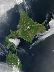
English: Satellite image of Hokkaido, Japan in May 2001. Taken from NASA's Visible Earth http://visibleearth.nasa.gov/view_rec.php?id=2060. This MODIS true-color image shows Hokkaido, Japan, at the top, and the northern tip of the island off Honshu at the bottom. Русский: Спутниковый снимок Хоккайдо (спутник Терра, NASA MODIS; май 2001 года) |
| Date | |
| Source | NASA |
| Auteur | NASA |
Conditions d’utilisation
[modifier]
| Ce fichier provient de la NASA. Sauf exception, les documents créés par la NASA ne sont pas soumis à copyright. Pour plus d'informations, voir la politique de copyright de la NASA. | ||
 |
Attention :
|
derivative works
[modifier]
Œuvres dérivées de ce fichier : Akan volcano meakan-dake hokkaido japan space shot.jpg
| Annotations | Cette image est annotée : Voir les annotations sur Wikimedia Commons |
Historique du fichier
Cliquer sur une date et heure pour voir le fichier tel qu'il était à ce moment-là.
| Date et heure | Vignette | Dimensions | Utilisateur | Commentaire | |
|---|---|---|---|---|---|
| actuel | 7 mai 2006 à 21:50 | | 2 400 × 3 200 (466 kio) | Akanemoto~commonswiki (d | contributions) | Satellite image of Hokkaido, Japan in May 2001. Taken from NASA's Visible Earth http://visibleearth.nasa.gov/view_rec.php?id=2060 |
Vous ne pouvez pas remplacer ce fichier.
Utilisations locales du fichier
Les 15 pages suivantes utilisent ce fichier :
- 北海道
- File:Akan volcano meakan-dake hokkaido japan space shot.jpg
- Category:Castles in Hokkaido
- Category:Dams in Hokkaido
- Category:Events in Hokkaido
- Category:Festivals of Hokkaido prefecture
- Category:Hokkaido
- Category:Michinoeki in Hokkaido
- Category:Mountains of Hokkaido
- Category:Sports in Hokkaido
- Category:Sports teams in Hokkaido
- Category:Towns in Hokkaido
- Category:Views of Hokkaido
- Category:Villages in Hokkaido
- Category:Visitor attractions in Hokkaido
Utilisations du fichier sur d’autres wikis
Les autres wikis suivants utilisent ce fichier :
- Utilisation sur af.wikipedia.org
- Utilisation sur ar.wikipedia.org
- Utilisation sur arz.wikipedia.org
- Utilisation sur ast.wikipedia.org
- Utilisation sur bo.wikipedia.org
- Utilisation sur ca.wikipedia.org
- Utilisation sur chr.wiktionary.org
- Utilisation sur en.wikipedia.org
- Utilisation sur en.wiktionary.org
- Utilisation sur eu.wikipedia.org
- Utilisation sur fr.wikipedia.org
- Utilisation sur ga.wikipedia.org
- Utilisation sur gl.wikipedia.org
- Utilisation sur ha.wikipedia.org
- Utilisation sur hif.wikipedia.org
- Utilisation sur hy.wikipedia.org
- Utilisation sur id.wikipedia.org
- Utilisation sur incubator.wikimedia.org
- Utilisation sur it.wikipedia.org
- Utilisation sur ja.wikipedia.org
- Utilisation sur ja.wikibooks.org
- Utilisation sur ko.wikipedia.org
- Utilisation sur la.wikipedia.org
- Utilisation sur ml.wikipedia.org
- Utilisation sur nn.wikipedia.org
- Utilisation sur oc.wikipedia.org
- Utilisation sur pam.wikipedia.org
- Utilisation sur pl.wikipedia.org
- Utilisation sur pl.wiktionary.org
- Utilisation sur pnb.wikipedia.org
- Utilisation sur pt.wikipedia.org
- Utilisation sur ru.wikipedia.org
- Utilisation sur ru.wikinews.org
- Utilisation sur sco.wikipedia.org
- Utilisation sur simple.wikipedia.org
- Utilisation sur sq.wikipedia.org
- Utilisation sur sr.wikipedia.org
- Utilisation sur sv.wikipedia.org
- Utilisation sur szl.wikipedia.org
- Utilisation sur ta.wikipedia.org
- Utilisation sur tg.wikipedia.org
Voir davantage sur l’utilisation globale de ce fichier.